
Portal:World
The World Portal


The world is the totality of entities, the whole of reality, or everything that exists. The nature of the world has been conceptualized differently in different fields. Some conceptions see the world as unique, while others talk of a "plurality of worlds". Some treat the world as one simple object, while others analyze the world as a complex made up of parts.
In scientific cosmology, the world or universe is commonly defined as "the totality of all space and time; all that is, has been, and will be". Theories of modality talk of possible worlds as complete and consistent ways how things could have been. Phenomenology, starting from the horizon of co-given objects present in the periphery of every experience, defines the world as the biggest horizon, or the "horizon of all horizons". In philosophy of mind, the world is contrasted with the mind as that which is represented by the mind.
Theology conceptualizes the world in relation to God, for example, as God's creation, as identical to God, or as the two being interdependent. In religions, there is a tendency to downgrade the material or sensory world in favor of a spiritual world to be sought through religious practice. A comprehensive representation of the world and our place in it, as is found in religions, is known as a worldview. Cosmogony is the field that studies the origin or creation of the world, while eschatology refers to the science or doctrine of the last things or of the end of the world.
In various contexts, the term "world" takes a more restricted meaning associated, for example, with the Earth and all life on it, with humanity as a whole, or with an international or intercontinental scope. In this sense, world history refers to the history of humanity as a whole, and world politics is the discipline of political science studying issues that transcend nations and continents. Other examples include terms such as "world religion", "world language", "world government", "world war", "world population", "world economy", or "world championship". (Full article...)
Selected articles -
-
 Contemptus mundi, the "contempt of the world" and worldly concerns, is a theme in the intellectual life of both Classical Antiquity and of Christianity, both in its mystical vein and its ambivalence towards secular life, that figures largely in the Western world's history of ideas. In inculcating a turn of mind that would lead to a state of serenity untrammeled by distracting material appetites and feverish emotional connections, which the Greek philosophers called ataraxia, it drew upon the assumptions of Stoicism and a neoplatonism that was distrustful of deceptive and spurious appearances. In the familiar rhetorical polarity in Hellenic philosophy between the active and the contemplative life, which Christians, who expressly rejected "the World, the Flesh, and the Devil", might exemplify as the way of Martha and the way of Mary, contemptus mundi assumed that only the contemplative life was of lasting value and the world an empty shell, a vanity. (Full article...)
 -
Gerardus Mercator (/dʒɪˈrɑːrdəs mɜːrˈkeɪtər/; 5 March 1512 – 2 December 1594) was a Flemish geographer, cosmographer and cartographer. He is most renowned for creating the 1569 world map based on a new projection which represented sailing courses of constant bearing (rhumb lines) as straight lines—an innovation that is still employed in nautical charts.
Mercator was a notable maker of globes and scientific instruments. In addition, he had interests in theology, philosophy, history, mathematics, and geomagnetism. He was also an accomplished engraver and calligrapher. Unlike other great scholars of the age, he travelled little and his knowledge of geography came from his library of over a thousand books and maps, from his visitors and from his vast correspondence (in six languages) with other scholars, statesmen, travellers, merchants and seamen. Mercator's early maps were in large formats suitable for wall mounting but in the second half of his life, he produced over 100 new regional maps in a smaller format suitable for binding into his Atlas of 1595. This was the first appearance of the word Atlas in reference to a book of maps. However, Mercator used it as a neologism for a treatise (Cosmologia) on the creation, history and description of the universe, not simply a collection of maps. He chose the word as a commemoration of the Titan Atlas, "King of Mauretania", whom he considered to be the first great geographer. (Full article...) -

The modern Olympic Games (Olympics; French: Jeux olympiques) are the world's leading international sporting events. They feature summer and winter sports competitions in which thousands of athletes from around the world participate in a variety of competitions. The Olympic Games are considered the world's foremost sports competition, with more than 200 teams, representing sovereign states and territories, participating. By default, the Games generally substitute for any world championships during the year in which they take place (however, each class usually maintains its own records). The Olympics are staged every four years. Since 1994, they have alternated between the Summer and Winter Olympics every two years during the four-year Olympiad.
Their creation was inspired by the ancient Olympic Games, held in Olympia, Greece, from the 8th century BC to the 4th century AD. Baron Pierre de Coubertin founded the International Olympic Committee (IOC) in 1894, leading to the first modern Games in Athens in 1896. The IOC is the governing body of the Olympic Movement, which encompasses all entities and individuals involved in the Olympic Games. The Olympic Charter defines their structure and authority. (Full article...) -

Water covers about 71% of Earth's surface.
The origin of water on Earth is the subject of a body of research in the fields of planetary science, astronomy, and astrobiology. Earth is unique among the rocky planets in the Solar System in having oceans of liquid water on its surface. Liquid water, which is necessary for all known forms of life, continues to exist on the surface of Earth because the planet is at a far enough distance (known as the habitable zone) from the Sun that it does not lose its water, but not so far that low temperatures cause all water on the planet to freeze.
It was long thought that Earth's water did not originate from the planet's region of the protoplanetary disk. Instead, it was hypothesized water and other volatiles must have been delivered to Earth from the outer Solar System later in its history. Recent research, however, indicates that hydrogen inside the Earth played a role in the formation of the ocean. The two ideas are not mutually exclusive, as there is also evidence that water was delivered to Earth by impacts from icy planetesimals similar in composition to asteroids in the outer edges of the asteroid belt. (Full article...) -

Conjectured illustration of the scorched Earth after the Sun has entered the red giant phase, about 5–7 billion years from now
The biological and geological future of Earth can be extrapolated based on the estimated effects of several long-term influences. These include the chemistry at Earth's surface, the cooling rate of the planet's interior, gravitational interactions with other objects in the Solar System, and a steady increase in the Sun's luminosity. An uncertain factor is the influence of human technology such as climate engineering, which could cause significant changes to the planet. For example, the current Holocene extinction is being caused by technology, and the effects may last for up to five million years. In turn, technology may result in the extinction of humanity, leaving the planet to gradually return to a slower evolutionary pace resulting solely from long-term natural processes.
Over time intervals of hundreds of millions of years, random celestial events pose a global risk to the biosphere, which can result in mass extinctions. These include impacts by comets or asteroids and the possibility of a near-Earth supernova—a massive stellar explosion within a 100-light-year (31-parsec) radius of the Sun. Other large-scale geological events are more predictable. Milankovitch's theory predicts that the planet will continue to undergo glacial periods at least until the Quaternary glaciation comes to an end. These periods are caused by the variations in eccentricity, axial tilt, and precession of Earth's orbit. As part of the ongoing supercontinent cycle, plate tectonics will probably create a supercontinent in 250–350 million years. Sometime in the next 1.5–4.5 billion years, Earth's axial tilt may begin to undergo chaotic variations, with changes in the axial tilt of up to 90°. (Full article...) -

A 12th-century manuscript of the Hippocratic Oath in Greek, one of the most famous aspects of classical medicine that carried into later eras
The history of medicine is both a study of medicine throughout history as well as a multidisciplinary field of study that seeks to explore and understand medical practices, both past and present, throughout human societies.
The history of medicine is the study and documentation of the evolution of medical treatments, practices, and knowledge over time. Medical historians often draw from other humanities fields of study including economics, health sciences, sociology, and politics to better understand the institutions, practices, people, professions, and social systems that have shaped medicine. When a period which predates or lacks written sources regarding medicine, information is instead drawn from archaeological sources. This field tracks the evolution of human societies' approach to health, illness, and injury ranging from prehistory to the modern day, the events that shape these approaches, and their impact on populations. (Full article...) -
Global citizenship is a form of transnationality, specifically the idea that one's identity transcends geography or political borders and that responsibilities or rights are derived from membership in a broader global class of "humanity". This does not mean that such a person denounces or waives their nationality or other, more local identities, but that such identities are given "second place" to their membership in a global community. Extended, the idea leads to questions about the state of global society in the age of globalization.
In general usage, the term may have much the same meaning as "world citizen" or cosmopolitan, but it also has additional, specialized meanings in differing contexts. Various organizations, such as the World Service Authority, have advocated global transnational citizenship. (Full article...)


General images -
-
 Tiktaalik, a fish with limb-like fins and a predecessor of tetrapods. Reconstruction from fossils about 375 million years old. (from History of Earth)
 -
 Artist's conception of Devonian flora (from History of Earth)
 -
 Artist's impression of Earth during the later Archean, the largely cooled planetary crust and water-rich barren surface, marked by volcanoes and continents, features already round microbialites. The Moon, still orbiting Earth much closer than today and still dominating Earth's sky, produced strong tides. (from History of Earth)
 -

-
 Portrait of Alfraganus in the Compilatio astronomica, 1493. Islamic astronomers began just before the 9th century to collect and translate Indian, Persian and Greek astronomical texts, adding their own astronomy and enabling later, particularly European astronomy to build on. Symbolic for the post-classical period, a period of an increasing trans-regional literary culture, particularly in the sciences, spreading and building on methods of science. (from Human history)
 -
 Artist's impression of a Hadean landscape with the relatively newly formed Moon still looming closely over Earth and both bodies sustaining strong volcanism. (from History of Earth)
 -
 Fall of the Berlin Wall, 1989
 -
 Notre-Dame de Paris, France
 -
 Lithified stromatolites on the shores of Lake Thetis, Western Australia. Archean stromatolites are the first direct fossil traces of life on Earth. (from History of Earth)
 -

-
 A reconstruction of human history based on fossil data. (from History of Earth)
 -
 Pillar erected by Ashoka, a Mauryan Emperor in India
 -
 A reconstruction of Pannotia (550 Ma). (from History of Earth)
 -
 A map of heat flow from Earth's interior to the surface of Earth's crust, mostly along the oceanic ridges (from Earth)
 -
 Ming dynasty section, Great Wall of China
 -
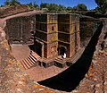 One of the eleven Rock-hewn Churches of Lalibela constructed during the Zagwe dynasty in Ethiopia (from Human history)
 -
 Geologic map of North America, color-coded by age. From most recent to oldest, age is indicated by yellow, green, blue, and red. The reds and pinks indicate rock from the Archean.
 -

-
 Taj Mahal, Mughal Empire, India
 -
 Dinosaurs were the dominant terrestrial vertebrates throughout most of the Mesozoic (from History of Earth)
 -

-
-

-
 Battle during the 1281 Mongol invasion of Japan
 -
 Artist's impression of the enormous collision that probably formed the Moon (from History of Earth)
 -
 Empires of the world in 1898
 -
 Carving of Persian and Median soldiers, Persepolis, Achaemenid Empire, 5th century BCE
 -
 A banded iron formation from the 3.15 Ga Moodies Group, Barberton Greenstone Belt, South Africa. Red layers represent the times when oxygen was available; gray layers were formed in anoxic circumstances. (from History of Earth)
 -
An artist's impression of the Archean, the eon after Earth's formation, featuring round stromatolites, which are early oxygen-producing forms of life from billions of years ago. After the Late Heavy Bombardment, Earth's crust had cooled, its water-rich barren surface is marked by continents and volcanoes, with the Moon still orbiting Earth half as far as it is today, appearing 2.8 times larger and producing strong tides. (from Earth)
-
 Change in average surface air temperature and drivers for that change. Human activity has caused increased temperatures, with natural forces adding some variability. (from Earth)
 -

-
 Successive dispersals of Homo erectus (yellow), Homo neanderthalensis (ochre) during Out of Africa I and Homo sapiens (red, Out of Africa II), with the numbers of years since they appeared before present. (from Human history)
 -
 Chennakesava Temple, Belur, India
 -
 Pale orange dot, an artist's impression of Early Earth, featuring its tinted orange methane-rich early atmosphere (from Earth)
 -
 COVID-19 pandemic, 2020 (from Human history)
 -
 Florence, birthplace of the Italian Renaissance
 -
 Chloroplasts in the cells of a moss (from History of Earth)
 -
 Graph showing range of estimated partial pressure of atmospheric oxygen through geologic time (from History of Earth)
 -
 Earth's history with time-spans of the eons to scale. Ma means "million years ago". (from History of Earth)
 -
 Pangaea was a supercontinent that existed from about 300 to 180 Ma. The outlines of the modern continents and other landmasses are indicated on this map. (from History of Earth)
 -
 An artist's rendering of a protoplanetary disk (from History of Earth)
 -
 A view of Earth with different layers of its atmosphere visible: the troposphere with its clouds casting shadows, a band of stratospheric blue sky at the horizon, and a line of green airglow of the lower thermosphere around an altitude of 100 km, at the edge of space (from Earth)
 -
 A schematic view of Earth's magnetosphere with solar wind flowing from left to right (from Earth)
 -
 A composite image of Earth, with its different types of surface discernible: Earth's surface dominating Ocean (blue), Africa with lush (green) to dry (brown) land and Earth's polar ice in the form of Antarctic sea ice (grey) covering the Antarctic or Southern Ocean and the Antarctic ice sheet (white) covering Antarctica. (from Earth)
 -
 An animation of the changing density of productive vegetation on land (low in brown; heavy in dark green) and phytoplankton at the ocean surface (low in purple; high in yellow) (from Earth)
 -
 A pillar at Neolithic Göbekli Tepe
 -
 An artist's impression of ice age Earth at glacial maximum. (from History of Earth)
 -
 Earth's night-side upper atmosphere appearing from the bottom as bands of afterglow illuminating the troposphere in orange with silhouettes of clouds, and the stratosphere in white and blue. Next the mesosphere (pink area) extends to the orange and faintly green line of the lowest airglow, at about one hundred kilometers at the edge of space and the lower edge of the thermosphere (invisible). Continuing with green and red bands of aurorae stretching over several hundred kilometers. (from Earth)
 -
 Machu Picchu, Inca Empire, Peru
 -
 Olmec colossal head, now at the Museo de Antropología de Xalapa
 -
 The first airplane, the Wright Flyer, flew on 17 December 1903.
 -
 Great Pyramids of Giza, Egypt
 -
 A composite image of artificial light emissions at night on a map of Earth (from Earth)
 -
 A computer-generated image mapping the prevalence of artificial satellites and space debris around Earth in geosynchronous and low Earth orbit (from Earth)
 -
 Benin Bronze head from Nigeria
 -
 European migrations by mostly Germanic peoples, 2nd–6th centuries (from Human history)
 -

-
 13th-century French historiated initial with the three classes of medieval society: those who prayed (the clergy), those who fought (the knights), and those who worked (the peasantry)
 -
 Earth's western hemisphere showing topography relative to Earth's center instead of to mean sea level, as in common topographic maps (from Earth)
 -
 A 2012 artistic impression of the early Solar System's protoplanetary disk from which Earth and other Solar System bodies were formed (from Earth)
 -
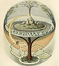 Yggdrasil, an attempt to reconstruct the Norse world tree which connects the heavens, the world, and the underworld. (from World)
 -
 Trilobites first appeared during the Cambrian period and were among the most widespread and diverse groups of Paleozoic organisms. (from History of Earth)
 -
 Satellite time lapse imagery of Earth's rotation showing axis tilt (from Earth)
 -
 Cross-section through a liposome (from History of Earth)
 -
 The replicator in virtually all known life is deoxyribonucleic acid. DNA is far more complex than the original replicator and its replication systems are highly elaborate. (from History of Earth)
 -
 Earth's land use for human agriculture in 2019 (from Earth)
 -
 Japanese depiction of a Portuguese carrack, a result of globalizing maritime trade
 -
The pale orange dot, an artist's impression of the early Earth which might have appeared orange through its hazy methane rich prebiotic second atmosphere. Earth's atmosphere at this stage was somewhat comparable to today's atmosphere of Titan. (from History of Earth)
-
 Artist's conception of Hadean Eon Earth, when it was much hotter and inhospitable to all forms of life. (from History of Earth)
 -

-

-
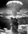
 Last Moon landing: Apollo 17 (1972)
 -

-
 Tracy Caldwell Dyson, a NASA astronaut, observing Earth from the Cupola module at the International Space Station on 11 September 2010 (from Earth)
 -
 A view of Earth with its global ocean and cloud cover, which dominate Earth's surface and hydrosphere; at Earth's polar regions, its hydrosphere forms larger areas of ice cover. (from Earth)
 -
 Cuneiform inscription, eastern Turkey
 -
 Standing Buddha from Gandhara, 2nd century CE
 -
 Image of the physical world, captured by the Hubble Space Telescope (from World)
 -
-
-
 Vitruvian Man by Leonardo da Vinci epitomizes the advances in art and science seen during the Renaissance. (from History of Earth)
 -
 Earth's axial tilt causing different angles of seasonal illumination at different orbital positions around the Sun (from Earth)
 -
 Shanghai. China urbanized rapidly in the 21st century.
 -
 A 580 million year old fossil of Spriggina floundensi, an animal from the Ediacaran period. Such life forms could have been ancestors to the many new forms that originated in the Cambrian Explosion. (from History of Earth)
 -
 Obelisk of Axum, Ethiopia
 -
 Angkor Wat temple complex, Cambodia, early 12th century
 -
 Artist's rendition of an oxinated fully-frozen Snowball Earth with no remaining liquid surface water. (from History of Earth)


.svg)


.jpg)


.png)
.jpeg)


.jpg)


Megacities of the world -

Guangzhou, previously romanized as Canton or Kwangchow, is the capital and largest city of Guangdong province in southern China. Located on the Pearl River about 120 km (75 mi) northwest of Hong Kong and 145 km (90 mi) north of Macau, Guangzhou has a history of over 2,200 years and was a major terminus of the Silk Road.
The port of Guangzhou serves as a transportation hub for Guangzhou, one of China's three largest cities. Guangzhou was captured by the British during the First Opium War and no longer enjoyed a monopoly after the war; consequently it lost trade to other ports such as Hong Kong and Shanghai, but continued to serve as a major entrepôt. Following the Second Battle of Chuenpi in 1841, the Treaty of Nanking was signed between Sir Robert Peel on behalf of Queen Victoria and Lin Zexu on behalf of Emperor Xuanzong and ceded Hong Kong to the United Kingdom on 26 January 1841 after the agreement of the Convention of Chuenpi. (Full article...)
Did you know -

- ... that a Stone Age Siberian village is the oldest known fortification in the world?
- ... that during the Second World War, the British government's campaign Make-Do and Mend encouraged the public to fashion men's clothes into womenswear?
- ... that Jane Dempsey Douglass became the first woman to head a worldwide communion of churches in 1990?
- ... that Misfat al Abriyeen in Oman was named one of the best tourism villages by the World Tourism Organization in 2021?
- ... that there was an organism from which all current life on Earth is descended?
- ... that a TV station in New York state signed on just to carry the 1953 World Series, then went off the air and did not start scheduled programming for several weeks?
- ... that after the 1931 Hawke's Bay earthquake destroyed Napier Technical College, it was disestablished and amalgamated into its rivals?
- ... that war correspondent Bernard Gray was killed while travelling as an unofficial passenger aboard a Royal Navy submarine during the Second World War?
Countries of the world -
.svg)
Portugal, officially the Portuguese Republic, is a country in the Iberian Peninsula in Southwestern Europe. Featuring the westernmost point in continental Europe, Portugal borders Spain to its north and east, with which it shares the longest uninterrupted border in the European Union; to the south and the west is the North Atlantic Ocean; and to the west and southwest lie the Macaronesian archipelagos of the Azores and Madeira, which are the two autonomous regions of Portugal. Lisbon is the capital and largest city, followed by Porto, which is the only other metropolitan area.
The western part of the Iberian Peninsula has been continuously inhabited since prehistoric times, with the earliest signs of settlement dating to 5500 BC. Celtic and Iberian peoples arrived in the first millennium BC. The region came under Roman control in the second century BC, followed by a succession of Germanic peoples and the Alans from the fifth to eighth centuries AD. Muslims invaded mainland Portugal in the eighth century, but were gradually expelled by the Christian Reconquista culminating with the capture of the Algarve, between 1238 and 1249 AD. Modern Portugal began taking shape during this period, initially as a county of the Christian Kingdom of León in 868 and recognized unequivocally as a kingdom with Manifestis Probatum in 1179. (Full article...)
Eighth Wonder of the World is an unofficial title sometimes given to new buildings, structures, projects, designs or even people that are deemed to be comparable to the seven Wonders of the World. (Full article...)
Related portals
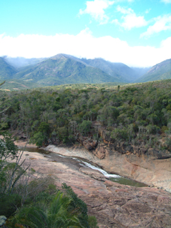
Protected areas of the world -
-
Andohahela National Park in southern Madagascar
The national parks of Madagascar include all officially recognized protected areas as of 2015. The protected areas network of Madagascar is managed by the Madagascar National Parks Association (PNM-ANGAP). The network includes three types of protected areas: Strict Nature Reserves (IUCN category Ia), National Parks (IUCN category II) and Wildlife Reserves (IUCN category IV). At the 2003 IUCN World Parks Congress in Durban, the Malagasy President, Marc Ravalomanana, announced an initiative to more than triple the area under protection from approximately 17,000 km2 (6,600 sq mi) to over 60,000 km2 (23,000 sq mi) (from 3% to 10% of Madagascar's area). This "Durban Vision", as it has been dubbed, involved broadening the definition of protected areas in the country and legislation has been passed to allow the creation of four new categories of protected area: Natural Parks (IUCN category II), Natural Monuments (IUCN category III), Protected Landscapes (IUCN category V), and Natural Resource Reserves (IUCN category VI). As well as allowing these new objectives for protected areas management, the new legislation also provided for entities other than PNM-ANGAP to manage protected areas, such as government ministries, community associations, NGOs and other civil society organizations, and the private sector. (Full article...) -
This is a list of protected areas of Saudi Arabia, some of which are managed by the Saudi Wildlife Authority.:
- At-Taysiyah Protected Area
- Jabal Shada Nature Reserve
- Majami'al-Hadb Protected Area
- Nafud al-'Urayq
- Raydah Natural Reserve
- 'Uruq Bani Ma'arid
- Saja Umm Ar-Rimth Natural Reserve
- Harrat al-Harrah Protected Area
- Al-Khunfah Natural Reserve
- Ibex Reserve Protected Area
- Mahazat as-Sayd Protected Area
- Umm al-Qamari Islands
- Al-Tubayq Natural Reserve
- Farasan Islands Protected Area
- Jubail Marine Wildlife Sanctuary
- Jabal Aja Protected Area
- Wadi Turabah Nature Reserve
-
The Australian Capital Territory as of 2014 contains 46 separate protected areas with a total land area of 1,302 km2 (503 sq mi) or 55.5% of the territory's area, and which managed by Territory and Municipal Services of the ACT government: (Full article...)
-
The following list of protected areas of British Columbia includes all federally and provincially protected areas within the Canadian province of British Columbia. As of 2015, approximately 15.46% of the province's land area and 3.17% of the province's waters are protected. (Full article...)
-

The northernmost tip of Prins Karls Forland in Forlandet National Park
Svalbard is an Arctic wilderness archipelago comprising the northernmost part of Norway. There are twenty-nine protected natural areas, consisting of seven national parks, six nature reserves, fifteen bird sanctuaries and one geotope protected area. In addition, human traces dating from before 1946 are automatically protected. The protected areas make up 39,800 square kilometers (15,400 sq mi) or 65% of the land area, and 78,000 square kilometers (30,000 sq mi) or 86.5% of the territorial waters. The largest protected areas are Nordaust-Svalbard Nature Reserve and Søraust-Svalbard Nature Reserve, which cover most of the areas east of the main island of Spitsbergen, including the islands of Nordaustlandet, Edgeøya, Barentsøya, Kong Karls Land and Kvitøya. Six of the national parks are located on Spitsbergen. Ten of the bird sanctuaries and the Moffen Nature Reserve are located within national parks. Five of the bird sanctuaries are Ramsar sites and fourteen of the bird sanctuaries are islands. Svalbard is on Norway's tentative list for nomination as a UNESCO World Heritage Site.
The supreme responsibility for conservation lies with the Norwegian Ministry of the Environment, which has delegated the management to the Governor of Svalbard and the Norwegian Directorate for Nature Management. The foundation for conservation was established in the Svalbard Treaty of 1920, and has been further specified in the Svalbard Environmental Act of 2001. The first round of protection took force on 1 July 1973, when most of the current protected areas came into effect. This included the two large nature reserves and three of the national parks. Moffen Nature Reserve was established in 1983, followed by four national parks, three nature reserves and one geotope protection area between 2002 and 2005. (Full article...) -
Protected areas of Norway include:
About 17 percent of the mainland of Norway is protected. Of this, ca. 8.3 percent is national parks, 1.3 percent is nature reserves and 4.7 percent otherwise protected. (Full article...) -
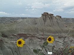
Dinosaur Provincial Park
This is a list of protected areas of Alberta. Protected areas are managed by the Government of Canada or the Government of Alberta. The provincial government owns 60% of Alberta's landmass but most of this has not been formally protected. The total protected area throughout Alberta including federal and provincial protected areas is approximately 90,700 km2 (35,000 sq mi). (Full article...) -
Protected areas of West Bengal cover 4% of the state area. Forests make up 14% of the geographical area of West Bengal, which is lower than the national average of 33%. West Bengal has a wide variety of fauna, including Bengal tigers, Indian leopards, sloth and Himalayan black bears, chital and sambar (deer), Indian boars, pygmy hogs, Indian elephants, Indian peafowl, great Indian hornbills, Eurasian spoonbills, brahminy ducks, king and Indian cobras, white-lipped pit viper, Indian and reticulated pythons, mugger crocodiles, saltwater crocodiles, gharials, and many more. A huge montane forest, Dooars, is situated in the Northern West Bengal districts of Alipur Duar, Darjeeling, and Kalimpong. Part of the world's largest mangrove forest, Sundarbans, is located in southern West Bengal.
There are 6 national parks and 15 wildlife sanctuaries in West Bengal. (Full article...) -

Overview of IUCN Protected area - WAP (W, Arli, Pendjari) area - Niger, Burkina Faso, and Benin
The following is a list of protected areas of Burkina Faso. (Full article...) -

The mountain of Stob Binnein lies in the Loch Lomond and The Trossachs National Park.
Many parts of Scotland are protected in accordance with a number of national and international designations because of their environmental, historical or cultural value. Protected areas can be divided according to the type of resource which each seeks to protect. NatureScot has various roles in the delivery of many environmental designations in Scotland, i.e. those aimed at protecting flora and fauna, scenic qualities and geological features. Historic Environment Scotland is responsible for designations that protect sites of historic and cultural importance. Some international designations, such as World Heritage Sites, can cover both categories of site.
The various designations overlap considerably with many protected areas being covered by multiple designations with different boundaries. (Full article...) -
The protected areas of Michigan come in an array of different types and levels of protection. Michigan has five units of the National Park Service system. There are 14 federal wilderness areas; the majority of these are also tribal-designated wildernesses. It has one of the largest state forest systems as well having four national forests. The state maintains a large state park system and there are also regional parks, and county, township and city parks. Still other parks on land and in the Great Lakes are maintained by other governmental bodies. Private protected areas also exist in the state, mainly lands owned by land conservancies. (Full article...)
-
Queensland is the second-largest state in Australia. As at 2020, it contained more than 1,000 protected areas. In August 2023, it was estimated a total of 14.5 million hectares or 8.38% of Queensland's landmass was protected. (Full article...)
-

Part of the Brecon Beacons National Park, looking from the highest point of Pen y Fan (886 m/2907 feet) to Cribyn (795 m/2608 feet).
Protected areas of the United Kingdom are areas in the United Kingdom which need and /or receive protection because of their environmental, historical or cultural value to the nation. Methods and aims of protection vary depending on the nature and importance of the resource. Protection operates at local, regional, national and international levels, and may be backed by legislation and international treaty, or less formally by planning policy.
Within the United Kingdom, different approaches are taken to some forms of protection within the constituent countries of England, Scotland, Wales and Northern Ireland, while other forms of protection are more consistent across the UK. Protected areas can be divided according to the type of resource which each seeks to protect. Primarily, these are: scenic or landscape value; biodiversity value (species and habitats); geodiversity value (relating to geology and geomorphology); and cultural or historic value. Several types of protected areas are focused on more than one of these areas. (Full article...) -

The Valley of the Giants skywalk at Walpole-Nornalup National Park
Western Australia is the second largest country subdivision in the world.
As of 2022, based on the latest Collaborative Australian Protected Areas Database report, it contains 1857 separate land-based protected areas with a total area of 76,142,710 hectares (188,152,700 acres), accounting for just over 30 percent of the state's land mass. By area, Indigenous Protected Areas account for the largest part of this, almost 67 percent while, by number, nature reserves hold the majority with two-third of all land-based protected areas being nature reserves. (Full article...) -

Ludaš Lake is a shallow lake in the province of Vojvodina in northern Serbia, near the city of Subotica. It is a special natural preserve and, since 1977, designated as a swamp area of international significance by the Ramsar Convention.
Protected areas cover around 5% of the territory of Serbia. The Law on the Protection of the Nature defines these categories of protected areas:- Strict nature reserve — Area of unmodified natural features with representative ecosystems set aside for the preservation of its biodiversity and for scientific research and monitoring.
- Special nature reserve — Area of unmodified or slightly modified natural features of great importance due to uniqueness and rarity which includes the habitats of endangered species set aside for the preservation of its unique features, education, limited tourism and for scientific research and monitoring.
- National park — Area with large number of diverse ecosystems of national value, with outstanding natural features and/or cultural heritage set aside for the preservation of its natural resources and for educational, scientific and tourist use.
- Natural monument — Small unmodified or slightly modified natural feature, object or phenomenon, easily detectable and unique, with unique natural attributes.
- Protected habitat — Area which includes habitats of one or more wildlife species.
- Landscape of outstanding features — Area of remarkable appearance with important natural and cultural value.
- Nature park — Area of well-preserved natural values with preserved natural ecosystems and picturesque landscape set aside for the preservation of biodiversity and for educational, tourist, recreational and scientific use.


Selected world maps
-
 United Nations Human Development Index map by country (2016)
 -
 The Goode homolosine projection is a pseudocylindrical, equal-area, composite map projection used for world maps.
 -
 Index map from the International Map of the World (1:1,000,000 scale)
 -
 Mollweide projection of the world
 -
 1516 map of the world by Martin Waldseemüller
 -
 Time zones of the world
 -
 Only a few of the largest large igneous provinces appear (coloured dark purple) on this geological map, which depicts crustal geologic provinces as seen in seismic refraction data
 -
 A plate tectonics map with volcano locations indicated with red circles
 -
 The world map by Gerardus Mercator (1569), the first map in the well-known Mercator projection


World records
- List of Olympic records in athletics
- List of world records in athletics
- List of junior world records in athletics
- List of world records in masters athletics
- List of world youth bests in athletics
- List of IPC world records in athletics
- List of world records in canoeing
- List of world records in chess
- List of cycling records
- List of world records in track cycling
- List of world records in finswimming
- List of world records in juggling
- List of world records in rowing
- List of world records in speed skating
- List of world records in swimming
- List of IPC world records in swimming
- List of world records in Olympic weightlifting
Topics

Continents of Earth | ||||||||
|---|---|---|---|---|---|---|---|---|
| ||||||||
| ||||||||
| ||||||||


| Cenozoic Era (present–66.0 Ma) |
| ||||||||||||
|---|---|---|---|---|---|---|---|---|---|---|---|---|---|
| Mesozoic Era (66.0–252 Ma) |
| ||||||||||||
| Paleozoic Era (252–539 Ma) |
| ||||||||||||
| Proterozoic Eon (539 Ma–2.5 Ga) |
| ||||||||||||
| Archean Eon (2.5–4 Ga) | |||||||||||||
| Hadean Eon (4–4.6 Ga) | |||||||||||||
ka = kiloannum (thousand years ago); Ma = megaannum (million years ago); Ga = gigaannum (billion years ago). See also: Geologic time scale • | |||||||||||||
| Locations | ||
|---|---|---|
| Related | ||

| |||||||||||||||||||
| |||||||||||||||||||
| |||||||||||||||||||
Economic classification of countries | |||||
|---|---|---|---|---|---|
| Three-World Model | |||||
| Gross domestic product (GDP) |
| ||||
| Gross national income (GNI) | |||||
| Wages | |||||
| Wealth | |||||
| Other national accounts | |||||
| Human development | |||||
| Digital divide | |||||
| Net international investment position (NIIP) | |||||
| Technological |
| ||||
|---|---|---|---|---|---|
| Sociological | |||||
| Ecological |
| ||||
| Biological |
| ||||
| Astronomical | |||||
| Eschatological |
| ||||
| Others |
| ||||
| Fictional | |||||
| Organizations | |||||
Categories

Wikimedia
The following Wikimedia Foundation sister projects provide more on this subject:
-
 Commons
Free media repository -
 Wikibooks
Free textbooks and manuals -
 Wikidata
Free knowledge base -
 Wikinews
Free-content news -
 Wikiquote
Collection of quotations -
 Wikisource
Free-content library -
 Wikispecies
Directory of species -
 Wikiversity
Free learning tools -
 Wikivoyage
Free travel guide -
 Wiktionary
Dictionary and thesaurus


