Sirihira
Appearance
Sirihira | |
|---|---|
Village | |
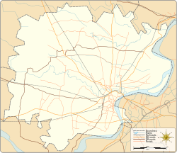
Village location on Varanasi district map | |
| Coordinates: 25°20′12″N 82°45′36″E / 25.33675°N 82.76005°E | |
| Country | |
| State | Uttar Pradesh |
| District | Varanasi district |
| Elevation | 88 m (289 ft) |
| Languages | |
| • Official | Hindi |
| Time zone | UTC+5:30 (IST) |
| Postal code | 221403 |
| Telephone code | +91-0542 |
| Vehicle registration | UP65 XXXX |
| Lok Sabha constituency | Varanasi |
| Vidhan Sabha constituency | Sewapuri |
Sirihira is a village in Sewapuri block of the Varanasi district in the Indian state of Uttar Pradesh The village is about 304 kilometers from Lucknow, the state capital, and around 804 kilometers from Delhi, the national capital.[1][2]
Transportation
[edit]Sirihira can be accessed by road and by Indian Railways. Closest railway station is Sewapuri. Closest operational airports are Varanasi airport (20 kilometers) and Prayagraj Airport (120 kilometers).[3][4]
See also
[edit]References
[edit]- ^ "Latitude and Longitude Finder on Map Get Coordinates". www.latlong.net. Archived from the original on 2025-03-10. Retrieved 2025-03-12.
- ^ "Sewapuri Pin Code (Varanasi, Uttar Pradesh) | Sewapuri Postal Index Number Code (Pincode)". Maps of India. Retrieved 2025-03-12.
- ^ "India Rail Info: The World's Largest Community of RailFans & Travellers". indiarailinfo.com. Retrieved 2025-03-12.
- ^ "AAI Airport's | AIRPORTS AUTHORITY OF INDIA". www.aai.aero. Archived from the original on 2025-01-02. Retrieved 2025-03-12.


