
Portal:New Guinea
The New Guinea Portal
Introduction
Native name: Papua, Niugini, Niu Gini | |
|---|---|
 | |
| Geography | |
| Location | Oceania (Melanesia) |
| Archipelago | Melanesia and Malay Archipelago |
| Area | 785,753 km2 (303,381 sq mi) |
| Area rank | 2nd |

New Guinea (Tok Pisin: Niugini; Hiri Motu: Niu Gini; Indonesian: Papua, fossilized Nugini, also known as Papua or historically Irian) is the world's second-largest island, with an area of 785,753 km2 (303,381 sq mi). Located in Melanesia in the southwestern Pacific Ocean, the island is separated from Australia by the 150-kilometre (81-nautical-mile; 93-mile) wide Torres Strait, though both landmasses lie on the same continental shelf, and were united during episodes of low sea level in the Pleistocene glaciations as the combined landmass of Sahul. Numerous smaller islands are located to the west and east. The island's name was given by Spanish explorer Yñigo Ortiz de Retez during his maritime expedition of 1545 due to the perceived resemblance of the indigenous peoples of the island to those in the African region of Guinea. (Full article...)
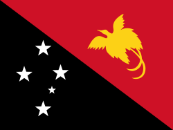
Papua New Guinea (PNG), officially the Independent State of Papua New Guinea, is an island country in Oceania that comprises the eastern half of the island of New Guinea and offshore islands in Melanesia, a region of the southwestern Pacific Ocean north of Australia. It has a land border with Indonesia to the west and maritime borders with Australia to the south and the Solomon Islands to the east. Its capital is Port Moresby. The country's 462,840 km2 (178,700 sq mi) includes a large mainland and hundreds of islands. (Full article...)
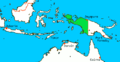
Western New Guinea, also known as Papua, Indonesian New Guinea, and Indonesian Papua, is the western half of the island of New Guinea, formerly Dutch and granted to Indonesia in 1962. Given the island is alternatively named Papua, the region is also called West Papua (Indonesian: Papua Barat). It is one of the seven geographical units of Indonesia in ISO 3166-2:ID. (Full article...)
Selected article -
-

Corruption in Papua New Guinea is rife.
According to The Economist, "PNG's governments are notorious for corruption, and ever run the risk of turning the state into a fully-fledged kleptocracy".
Transparency International's Corruption Perceptions Index scores 180 countries according to the perceived corruption of their public sector on a scale from 0 ("highly corrupt") to 100 ("very clean"). Those countries are then ranked by their score; the country ranked first is perceived to have the most honest public sector. In the 2024 Index, Papua New Guinea scored 31 and ranked 127th. For comparison with regional scores, the best score among the countries of the Asia Pacific region was 84, the average score was 44 and the worst score was 16. For comparison with worldwide scores, the best score was 90 (ranked 1), the average score was 43, and the worst score was 8 (ranked 180).
Papua New Guinea is below the satisfactory levels set by the United Nations Convention against Corruption (UNCAC), according to a report submitted by Transparency International Papua New Guinea (TIPNG) in 2011. TIPNG’s report found that in many cases, anti-corruption bodies in PNG were restricted by shortcomings in financial resources. (Full article...) -
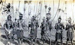
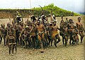
Tolai dancers
The Tolai are the indigenous people of the Gazelle Peninsula and the Duke of York Islands of East New Britain in the New Guinea Islands region of Papua New Guinea. They are ethnically close kin to the peoples of adjacent New Ireland and tribes like the Tanga people and are thought to have migrated to the Gazelle Peninsula in relatively recent times, displacing the Baining people who were driven westwards.
The majority of Tolais speak Kuanua as their first language (~100,000). Two other languages are spoken as first languages: Lungalunga and Bilur, each with approximately 2,000 speakers.
The Tolais almost universally define themselves as Christian and are predominantly Roman Catholic and United Church. Christianity was introduced to the island when Methodist ministers and teachers from Fiji arrived in the New Guinea islands region in 1875. However, in 1878 when some of the tribespeople ate four of the missionaries, the Englishman who led the missionaries, George Brown, directed and took part in a punitive expedition that resulted in a number of Tolais being killed and several villages burnt down. (Full article...) -
Kokopo is the capital of East New Britain Province in Papua New Guinea. It is administered under Kokopo/Vunamami Urban LLG. The capital was moved from Rabaul in 1994 when the volcanoes Tavurvur and Vulcan erupted. As a result, the population of the town increased more than sixfold from 3,150 in 1990 to 20,262 in 2000.
Kokopo was known as Herbertshöhe (Herbert's Heights), named in honour of Herbert, eldest son of German Chancellor Otto von Bismarck, during the German New Guinea administration, which controlled the area between 1884 and formally until 1919. Until 1910, it was the capital of German New Guinea.
On Sunday, March 29, 2015, a strong earthquake, of a preliminary magnitude of at least 7.5, which at that time was the largest earthquake of 2015, was recorded near Kokopo, and a tsunami warning was issued. This was surpassed a month later by the April 2015 Nepal earthquake, which measured a magnitude 7.8. (Full article...) -

The Papua conflict (Indonesian: Konflik Papua) is an ongoing conflict in Western New Guinea between Indonesia and the Free Papua Movement (Indonesian: Organisasi Papua Merdeka, OPM), a pro-independence group in the region. Following the withdrawal of Dutch colonial rule from Netherlands New Guinea in 1962, the United Nations (UN) oversaw a short transitional period before Indonesia took full control in 1963. Since then, Papuan fighters have launched a low-intensity armed resistance targeting the military and police, alongside acts of civil resistance and peaceful protests. Many Papuans seek full independence or unification with Papua New Guinea, raising the Morning Star flag in defiance of Indonesian repression.
Widespread atrocities committed by Indonesian forces have led human rights groups to describe the situation as a genocide against the indigenous Papuan population. Reports of mass killings, forced displacement, and sexual violence are extensive and credible. According to a 2007 estimate by scholar De R. G. Crocombe, between 100,000 and 300,000 Papuans have been killed since Indonesia's occupation began. A 2004 report by Yale Law School argued that the scale and intent of Indonesia’s actions fall within the legal definition of genocide. State violence has targeted women in particular. A 2013 and 2017 study by AJAR and the Papuan Women's Working Group found that 4 in 10 Papuan women reported suffering state abuse, while a 2019 follow-up found similar results.
In 2022, the UN condemned what it described as "shocking abuses" committed by the Indonesian state, including the killing of children, disappearances, torture, and large-scale forced displacement. It called for "urgent and unrestricted humanitarian aid to the region." Human Rights Watch (HRW) has noted that the Papuan region functions as a de facto police state, where peaceful political expression and independence advocacy are met with imprisonment and violence. While some analysts argue that the conflict is aggravated by a lack of state presence in remote areas, the overwhelming trend points to systemic state violence and neglect. (Full article...) -
Hermann Philipp Detzner (16 October 1882 – 1 December 1970) was a German engineer and surveyor, who served as an officer in the German colonial security force (Schutztruppe) in Kamerun (Cameroon) and German New Guinea. He gained fame for evading capture after Australian troops invaded German New Guinea at the start of World War I.
In early 1914, the German government sent Detzner to explore and chart central Kaiser-Wilhelmsland, the imperial protectorate on the island of New Guinea. When World War I broke out in Europe, he was far from civilisation and without radio contact. He refused to surrender to Australian troops when they occupied German New Guinea, concealing himself in the jungle with a band of approximately 20 soldiers. For four years, Detzner and his troops provocatively marched through the bush, singing "Watch on the Rhine" and flying the German Imperial flag. He led at least one expedition from the Huon Peninsula to the north coast, and a second by a mountain route, to attempt an escape to the neutral Dutch colony to the west. He explored areas of the New Guinea's hinterland formerly unseen by Europeans.
After finding out that the war had ended, Detzner surrendered in full dress uniform, flying the Imperial flag, to Australian forces in January 1919. He received a hero's welcome when he returned to Germany. He wrote a book about his adventures – Four Years Among the Cannibals in the Interior of German New Guinea under the Imperial Flag, from 1914 until the Armistice – that sold well in Great Britain and Germany, entered three printings, and was translated into French, English, Finnish and Swedish. He received a position in the Imperial Colonial Archives, and appeared frequently on the lecture circuit throughout the 1920s. In the late 1920s, scientific portions of his book were discredited. In 1932, he admitted that he had mixed fact and fiction and, after that time, eschewed public life. (Full article...) -
The Kaluli creation myth is a traditional creation myth of the Kaluli people of Papua New Guinea. In the version as was recorded by anthropologist and ethnographer Edward L. Shieffelin whose first contact with them took place in the late 1960s. The story begins in a time the Kaluli call hena madaliaki, which translates "when the land came into form." During the time of hena madaliaki people covered the earth but there was nothing else: no trees or plants, no animals, and no streams. With nothing to use for food or shelter, the people became cold and hungry. Then one man among them (alternative accounts give two) gathered everyone together and delegated different tasks. He directed one group to become trees and they did. He directed another to become sago, yet another to be fish, another banana and so forth until the world was brimming with animals, food, streams, mountains and all other natural features. There were only a few people left and they became the ancestors of present-day human beings.
The Kaluli describe this story as "the time when everything alə bano ane" which means roughly "the time when everything divided". This concept of all world phenomena as a result of a "splitting" has many echos in Kaluli thought and cultural practices. In the Kaluli world view, all of existence is made from people who differentiated into different forms. Animals, plants, streams and people are all the same except in the form they have assumed following this great split. Death is another splitting. The Kaluli have no concept of a transcendent, sacred domain that is spiritual or in any fundamental way distinct from the natural, material world; instead death is another event that divides beings through the acquisition of new forms which are unrecognizable to the living.
The Kaluli are an indigenous people whose first contact with contemporary western civilization began in the 1940s. Following extensive Christian missionary efforts in the region, variants of the traditional creation story have adopted a few Christian elements. Prior to contact, the Kaluli story described creation as a pragmatic solution to problems of cold and hunger, and the efforts were initiated by one or two ordinary and unnamed men rather than any deity or deities. The Kaluli have since tended to identify one or both of them as "Godeyo" (God) and "Yesu" (Jesus Christ). (Full article...) -
The New Guinea crocodile (Crocodylus novaeguineae) is a small species of crocodile found on the island of New Guinea north of the mountain ridge that runs along the centre of the island. The population found south of the mountain ridge, formerly considered a genetically distinct population, is now considered a distinct species, Hall's New Guinea crocodile (C. halli). In the past it included the Philippine crocodile, C. n. mindorensis, as a subspecies, but today they are regarded as separate species. The habitat of the New Guinea crocodile is mostly freshwater swamps and lakes. It is most active at night when it feeds on fish and a range of other small animals. A female crocodile lays a clutch of eggs in a nest composed of vegetation and she lies up nearby to guard the nest. There is some degree of parental care for newly hatched juveniles. This crocodile was over-hunted for its valuable skin in the mid 20th century, but conservation measures have since been put in place, it is reared in ranches and the International Union for Conservation of Nature (IUCN) lists it as being of "Least Concern". (Full article...) -

Matschie's tree-kangaroo, an endangered endemic species found in Huon Peninsula
Papua New Guinea together with the West Papua region of Indonesia (New Guinea) makes up a major tropical wilderness area that still contains 5% of the original and untouched tropical high-biodiversity terrestrial ecosystems. PNG in itself contains over 5% of the world's biodiversity in less than 1% of the world's total land area. The flora of New Guinea is unique because it has two sources of origin; the Gondwana flora from the south and flora with Asian origin from the west. As a result, New Guinea shares major families and genera with Australia and East Asia, but is rich in local endemic species. Endemism is a result of mountainous isolation, topographic and soil habitat heterogeneity, high forest disturbance rates and abundant aseasonal rainfall year round. PNG boasts some 15–21,000 higher plants, 3,000 species of orchids, 800 species of coral, 600 species of fish, 250 species of mammals and 760 species of birds and 8 species of tree-kangaroos of which 84 genera of animals are endemic. Ecosystems range from lowland forests to montane forests, alpine flora down to coastal areas which contain some of the most extensive pristine mangrove areas in the world. Much of this biodiversity has remained intact for thousands of years because the ruggedness of the terrain made the interior lands inaccessible; furthermore low population density and restrictions on the effectiveness of traditional tools, ensured that this biodiversity was never overexploited. (Full article...) -
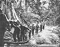
The New Guinea Volunteer Rifles (NGVR) was an infantry battalion of the Australian Army. It was initially raised as a unit of the Militia from white Australian and European expatriates in New Guinea upon the outbreak of the Second World War in 1939, before being activated for full-time service following the Japanese landings in early 1942. NGVR personnel then helped rescue survivors of Lark Force from Rabaul in February and March 1942. Between March and May, the NGVR monitored the Japanese bases which had been established in the Huon Gulf region, being the only Allied force in the area until the arrival of Kanga Force at Wau in May. The battalion subsequently established observation posts overlooking the main approaches and reported on Japanese movements.
Later, it inflicted significant casualties on the Japanese in a series of raids, and led them to believe that they faced a much larger opposing force. On 29 June, the NGVR and the newly arrived 2/5th Independent Company carried out a highly successful attack on the Japanese garrison in Salamaua, killing at least 113 men. When the focus shifted to the Milne Bay and Kokoda Track battles of August and September, the NGVR continued to man its posts overlooking the Japanese base areas. The Japanese were subsequently defeated in the Battle of Wau in January and February 1943, relieving the pressure on the NGVR. The battalion was disbanded in April 1943 due to attrition.
In the years immediately following the war the Australian Army considered re-establishing a military presence in Papua New Guinea (PNG), although there was some opposition among white settlers to the raising of native units. As an interim measure, the re-establishment of the NGVR was approved in July 1949. The unit reformed as the Papua New Guinea Volunteer Rifles (PNGVR) on 16 March 1951, initially as a whites-only reserve unit of the Citizen Military Forces (CMF). In March 1951 a PNGVR detachment assisted in relief operations following the eruption of Mount Lamington, which killed 3,466 people and left more than 5,000 homeless. Between 1951 and 1953 PNGVR elements were established in all the main centres of Papua New Guinea. (Full article...) -
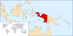
Western New Guinea, also known as Papua, Indonesian New Guinea, and Indonesian Papua, is the western half of the island of New Guinea, formerly Dutch and granted to Indonesia in 1962. Given the island is alternatively named Papua, the region is also called West Papua (Indonesian: Papua Barat). It is one of the seven geographical units of Indonesia in ISO 3166-2:ID.
Lying to the west of Papua New Guinea and geographically a part of the Australian continent, the territory is almost entirely in the Southern Hemisphere and includes the Biak and Raja Ampat archipelagoes. The region is predominantly covered with rainforest where traditional peoples live, including the Dani of the Baliem Valley. A large proportion of the population live in or near coastal areas. The largest city is Jayapura.
The island of New Guinea has been populated for tens of thousands of years. European traders began frequenting the region around the late 16th century due to spice trade. In the end, the Dutch Empire emerged as the dominant leader in the spice war, annexing the western part of New Guinea into the colony of Dutch East Indies. The Dutch remained in New Guinea until 1962, even though other parts of the former colony has declared independence as the Republic of Indonesia in 1945. Following negotiations and conflicts with the Indonesian government, the Dutch transferred Western New Guinea to a United Nations Temporary Executive Authority (UNTEA) in 1962, which was again transferred to Indonesia after the controversial Act of Free Choice in 1969. (Full article...) -
Lesbian, gay, bisexual, and transgender (LGBT) people in Papua New Guinea face legal challenges not experienced by non-LGBTQ residents. Male same-sex sexual activity is illegal, punishable by up to 14 years' imprisonment. The law is rarely enforced, but arrests still do happen, having occurred in 2015 and 2022. There are no legal restrictions against lesbian sex in the country.
Attitudes towards LGBT people are greatly influenced by Christian churches, as a majority of Papua New Guineans are Christian. Historically, gay men had certain societal roles. They would take on traditional female roles such as cooking and would participate with women in traditional festivals. However, some tribes were observed to have practiced ritual homosexuality, such as the Etoro, Kaluli, and Sambia peoples.
A lot of the attitudes towards LGBT people are also influenced by Australia's early occupation of Papua New Guinea. The Australian criminal law, originally derived from the Queensland Criminal Code created during British colonization, was extended to Papua New Guinea. Despite the Australian states starting to decriminalize same-sex sexual activity in 1975, Papua New Guinea retained this provision due to gaining independence in the same year, resulting in the continued criminalization of such activity there. (Full article...) -
The Royal Pacific Islands Regiment (RPIR) is an infantry regiment of the Papua New Guinea Defence Force (PNGDF). The regiment is descended from the Australian Army infantry battalions formed from native soldiers and Australian officers and non-commissioned officers in the territories of Papua and New Guinea during World War II to help fight against the Japanese. Disbanded after the war, the regiment was re-raised in 1951 as part of the Australian Army and continued to serve until Papua New Guinea gained its independence in 1975, when it became part of the PNGDF. Today, the RPIR consists of two battalions and has seen active service in Vanuatu, Bougainville and the Solomon Islands. (Full article...)
-

Dutch New Guinea or Netherlands New Guinea (Dutch: Nederlands-Nieuw-Guinea, Indonesian: Irian Belanda) was the western half of the island of New Guinea that was a part of the Dutch East Indies until 1949, later an overseas territory of the Kingdom of the Netherlands from 1949 to 1962. It contained what are now Indonesia's six easternmost provinces, Central Papua, Highland Papua, Papua, South Papua, Southwest Papua, and West Papua, which were administered as a single province prior to 2003 under the name Irian Jaya, and now comprise the Papua region of the country.
During the Indonesian Revolution, the Dutch launched politionele acties to capture territory from the Indonesian Republic. However, the harsh methods of the Dutch had drawn international disapproval. With international opinion shifting towards support of the Indonesian Republic, the Dutch managed in 1949 to negotiate for the separation of Dutch New Guinea from the broader Indonesian settlement, with the fate of the disputed territory to be decided by the close of 1950. However, the Dutch in coming years were able to argue successfully at the UN that the indigenous population of Dutch New Guinea represented a separate ethnic group from the people of Indonesia and thus should not be absorbed into the Indonesian state.
In contrast, the Indonesian Republic, as successor state to the Netherlands East Indies, claimed Dutch New Guinea as part of its natural territorial bounds. The dispute over New Guinea was an important factor in the quick decline in bilateral relations between the Netherlands and Indonesia after Indonesian independence. The dispute escalated into low-level conflict in 1962 following Dutch moves in 1961 to establish a New Guinea Council. (Full article...) -
Rabaul (/rɑːˈbaʊl/) is a township in the East New Britain province of Papua New Guinea, on the island of New Britain. It lies about 600 km (370 mi) to the east of the island of New Guinea. Rabaul was the provincial capital and most important settlement in the province until it was destroyed in 1994 by falling ash from a volcanic eruption in its harbor. During the eruption, ash was sent thousands of metres into the air, and the subsequent rain of ash caused 80% of the buildings in Rabaul to collapse. After the eruption the capital was moved to Kokopo, about 20 kilometres (12 mi) away. Rabaul is continually threatened by volcanic activity, because it is on the edge of the Rabaul caldera, a flooded caldera of a large pyroclastic shield volcano.
Rabaul was planned and built around the harbour area known as Simpsonhafen (Simpson Harbour) during the German New Guinea administration, which controlled the region from 1884 and formally through 1919. Rabaul was selected as the capital of the German New Guinea administration in 1905, and the administrative offices were transferred there in 1910. Rabaul was captured by the British Empire during the early days of World War I. It became the capital of the Australian-mandated Territory of New Guinea until 1937, when it was first destroyed by a volcano. During World War II, it was captured by Japan in 1942 and became its main base of military and naval activity in the South Pacific. Settlements and military installations around the edge of the caldera are often collectively called Rabaul, although the old town of Rabaul was reduced to practical insignificance by the volcanic eruption in 1937.
As a tourist destination, Rabaul is popular for its volcanoes, scuba diving and for snorkelling sites, spectacular harbour and other scenery, World War II history, flora and fauna, and the cultural life of the Tolai people. Before the 1994 eruption, Rabaul was a popular commercial and recreational boating destination; fewer private small craft visit now, but 10 to 12 cruise ships visit Rabaul each year, including the Queen Elizabeth, carrying up to 2,000 passengers. Tourism is a major industry in Rabaul and East New Britain generally. (Full article...) -
The Panguna mine is a large copper mine located in Bougainville, Papua New Guinea. Panguna represents one of the largest copper reserves in Papua New Guinea and in the world, having an estimated reserve of one billion tonnes of ore copper and twelve million ounces of gold. The mine has been closed since 1989 and has ceased all production. (Full article...)


.svg)


.jpg)


Did you know (auto-generated)

- ... that Dorkas Tokoro-Hanasbey, the only female member of the New Guinea Council, arrived thirty minutes late to her inauguration ceremony?
- ... that David Dexter, who wrote the New Guinea volume in the series Australia in the War of 1939–1945, was a commando who served in East Timor and New Guinea?
- ... that in 1984, more than 10,000 Papuans from West Papua crossed into Papua New Guinea as refugees due to a government crackdown?
- ... that artifacts of Papua New Guinean art were called "living spirits with fixed abodes"?
- ... that Australian official Jack Emanuel was awarded the George Cross in 1971 after being stabbed to death whilst trying to resolve a land dispute with the Tolai people of New Guinea?
- ... that Australiformis semoni is a parasite that infests marsupials in Australia and New Guinea and whose infestation could cause debilitating ulcerative granulomatous gastritis?
General images -
-
 Sago is a typical Papuan food, which is usually made into papeda. (from Western New Guinea)
 -
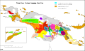
 Political divisions of New Guinea (2006) (from New Guinea)
 -
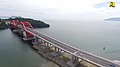 Youtefa Bridge, currently the longest bridge in Papua (from Western New Guinea)
 -
 Fort Du Bus in 1828 (from Western New Guinea)
 -

-
 Mount Bosavi (from New Guinea)
 -
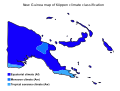 Papua New Guinea map of Köppen climate classification (from New Guinea)
 -
 The Sukarno-era West Irian Liberation Monument in Lapangan Banteng, Jakarta. (from Western New Guinea)
 -
 A Japanese military map of New Guinea from 1943 (from New Guinea)
 -
 Sentani International Airport in Jayapura is the principal point of entry to Papua (from Western New Guinea)
 -
 The king bird-of-paradise is one of over 300 bird species on the peninsula. (from Western New Guinea)
 -
 Jayapura, the most populous and largest city on the island of New Guinea (Papua) (from New Guinea)
 -
 Free West Papua protest in Melbourne, Australia, August 2012. (from Western New Guinea)
 -
 Dutch colonial civil servant in the Baliem Valley, 1958 (from Western New Guinea)
 -

-
 Regions of Oceania: Australasia, Polynesia, Micronesia, and Melanesia. Australasia includes the Australian landmass (including Tasmania), New Zealand, and New Guinea. (from History of Papua New Guinea)
 -
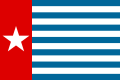 Since 2002, display of the flag of West Papua is allowed in West Papua only if accompanied by, and not raised higher than, the flag of Indonesia. (from Western New Guinea)
 -
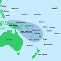 New Guinea located in relation to Melanesia (from New Guinea)
 -
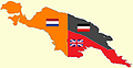 New Guinea from 1884 to 1919. The Netherlands controlled the western half of New Guinea, Germany the north-eastern part, and Britain the south-eastern part. (from New Guinea)
 -
-
 Australian patrol officer in 1964 (from History of Papua New Guinea)
 -
 A section of Trans-Papua Highway connecting Deiyai and Mimika in Central Papua (from Western New Guinea)
 -
 British flag raised in Queensland 1883 (from History of Papua New Guinea)
 -
 Yali in the Yahukimo Regency (from Western New Guinea)
 -
 A typical map from the Golden Age of Netherlandish cartography. Australasia during the Golden Age of Dutch exploration and discovery (ca. 1590s–1720s): including Nova Guinea (New Guinea), Nova Hollandia (mainland Australia), Van Diemen's Land (Tasmania), and Nova Zeelandia (New Zealand). (from History of Papua New Guinea)
 -
 Western New Guinea was formally annexed by Indonesia in 1969. (from New Guinea)
 -
-
 Australian troops at Milne Bay, Papua.The Australian garrison was the first to inflict defeat on the Imperial Japanese Army during World War II at the Battle of Milne Bay of Aug–Sep 1942. (from History of Papua New Guinea)
 -
 Map of New Guinea, with place names as used in English in the 1940s (from New Guinea)
 -
 The rugged and mountainous topography of Western New Guinea. (from Western New Guinea)
 -
 Map showing the combined landmass of Sahul formed during Pleistocene glacations (from New Guinea)
 -
 Flag under German control of New Guinea. (from History of Papua New Guinea)
 -
 Koiari village near Bootless Inlet, British New Guinea (from History of Papua New Guinea)
 -

-
 Culture parade in Biak (from Western New Guinea)
 -

-
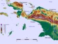
 Topographical map of New Guinea (from New Guinea)
 -
 New Guinea crocodile (from New Guinea)
 -
 Australian forces attack Japanese positions during the Battle of Buna–Gona, 7 January 1943. (from History of Papua New Guinea)
 -
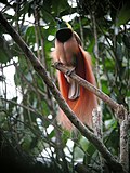 The raggiana bird-of-paradise is native to New Guinea. (from New Guinea)
 -
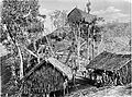
 Papuans on the Lorentz River, photographed during the third South New Guinea expedition in 1912–13 (from New Guinea)
 -
 The Nagarakertagama mentioned a region in the east called Wanin, present-day Onin Peninsula in the Fakfak Regency, West Papua (from Western New Guinea)
 -
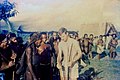
![Image 43M.S. Rumagesan, Silas Papare, N.L.Suwages, Soegoro Atmoprasodjo [id], and A.H. Nasution in Putra-putra Irian Barat ('Sons of Irian Barat') Conference in Cibogo Bogor, 14–15 April 1961 (from Western New Guinea)](//upload.wikimedia.org/wikipedia/commons/thumb/7/74/MS_Rumagesan%2C_Silas_Papare%2C_NL_Suwages%2C_Sugoro%2C_dan_AH_Nasution_berbincang-bincang%2C_Konferensi_Cibogo.jpg/120px-MS_Rumagesan%2C_Silas_Papare%2C_NL_Suwages%2C_Sugoro%2C_dan_AH_Nasution_berbincang-bincang%2C_Konferensi_Cibogo.jpg) M.S. Rumagesan, Silas Papare, N.L.Suwages, Soegoro Atmoprasodjo, and A.H. Nasution in Putra-putra Irian Barat ('Sons of Irian Barat') Conference in Cibogo Bogor, 14–15 April 1961 (from Western New Guinea)
M.S. Rumagesan, Silas Papare, N.L.Suwages, Soegoro Atmoprasodjo, and A.H. Nasution in Putra-putra Irian Barat ('Sons of Irian Barat') Conference in Cibogo Bogor, 14–15 April 1961 (from Western New Guinea) -
New Guinea from 1884 to 1919. Germany and Britain controlled the eastern half of New Guinea. (from History of Papua New Guinea)
-
 Female gable image, Sawos people, Oceanic art in the Bishop Museum (from History of Papua New Guinea)
 -
 Fishing boats in Biak (from Western New Guinea)
 -
 Trans-New Guinea languages (multi-coloured), Austronesian languages (gold), and other languages (grey) (from Western New Guinea)
 -
 The lowland rainforest of the Western New Guinea (from Western New Guinea)
 -
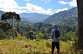 Highlands of Papua New Guinea (from New Guinea)
 -
 An Australian soldier, Private George "Dick" Whittington, is aided by Papuan orderly Raphael Oimbari, near Buna on 25 December 1942. (from History of Papua New Guinea)
 -
 West Papuan separatists raising the Morning-Star flag in the jungles of Papua, 1971 (from Western New Guinea)
 -
 Group of natives at Mairy Pass. Mainland of British New Guinea in 1885. (from New Guinea)
 -
 The floristic region of Malesia (from New Guinea)
 -
 Grasberg Mine in Mimika Regency. Mining is the most important sector in the province (from Western New Guinea)
 -

-
A 1644 map of New Guinea and the surrounding area (from New Guinea)
-
 Yali Mabel, Kurulu Village War Chief at Baliem Valley (from New Guinea)
 -
 Papeda, a notable dish originating from Eastern Indonesia (from Western New Guinea)
 -
 Skouw border checkpoint, on the Indonesia-Papua New Guinea border (from Western New Guinea)
 -
 Dutch expeditions in Netherlands New Guinea 1907–1915. (from Western New Guinea)
 -
 Rp 0.12 Indonesian stamp of 1963. (from Western New Guinea)
 -
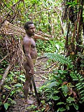 Korowai tribesman (from New Guinea)
 -
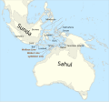
The continent of Sahul before the rising ocean sundered Australia and New Guinea after the last ice age (from New Guinea)
-
Dutch expeditions in Netherlands New Guinea 1907–1915. (from Western New Guinea)
-
-
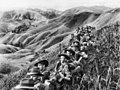 Australian soldiers resting in the Finisterre Ranges of New Guinea while en route to the front line (from New Guinea)
 -
 Handover ceremony of West Irian Governorship from Jan Bonay to Frans Kaisiepo, 1965 (from Western New Guinea)
 -
 Paradisaea apoda, native to Papua, displaying its feathers (from Western New Guinea)
 -
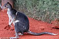 Dorcopsis hageni, native to northern region of New Guinea. (from Western New Guinea)
 -
 Dutch and Papuan officials during the opening of the Central Hospital in Hollandia, 1959 (from Western New Guinea)
 -
 Kerepunu women at the marketplace of Kalo, British New Guinea, 1885 (from History of Papua New Guinea)
 -
 New Guinea Volunteer Rifles with captured Japanese flag, 1942 (from History of Papua New Guinea)
 -
 Coral reefs in Papua New Guinea (from New Guinea)
 -
 Hoisting the German flag at Mioko in 1884 (from History of Papua New Guinea)
 -
Regions of Oceania: Australasia, Polynesia, Micronesia, and Melanesia. Physiographically, Australasia includes the Australian landmass (including Tasmania), New Zealand, and New Guinea (from New Guinea)


.png)


.jpg)


.jpg)


![Image 43M.S. Rumagesan, Silas Papare, N.L.Suwages, Soegoro Atmoprasodjo [id], and A.H. Nasution in Putra-putra Irian Barat ('Sons of Irian Barat') Conference in Cibogo Bogor, 14–15 April 1961 (from Western New Guinea)](/wiki/File:MS_Rumagesan,_Silas_Papare,_NL_Suwages,_Sugoro,_dan_AH_Nasution_berbincang-bincang,_Konferensi_Cibogo.jpg)


.jpg)


,_Pairi_daiza_2.jpg)


.jpg)


Related portals
WikiProjects
General topics
Categories

Associated Wikimedia
The following Wikimedia Foundation sister projects provide more on this subject:
-
 Commons
Free media repository -
 Wikibooks
Free textbooks and manuals -
 Wikidata
Free knowledge base -
 Wikinews
Free-content news -
 Wikiquote
Collection of quotations -
 Wikisource
Free-content library -
 Wikiversity
Free learning tools -
 Wiktionary
Dictionary and thesaurus
External media

More portals


