
Masuleh
This article needs additional citations for verification. (February 2023) |
Masuleh
Persian: ماسوله | |
|---|---|
City | |
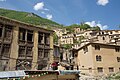
 Masuleh view | |
 Masuleh | |
| Coordinates: 37°09′18″N 48°59′22″E / 37.15500°N 48.98944°E[1] | |
| Country | Iran |
| Province | Gilan |
| District | Sardar-e Jangal |
| Population (2016)[2] | |
• Total | 393 |
| Time zone | UTC+3:30 (IRST) |
Masuleh (Persian: ماسوله; ⓘ)[a] is a city in Sardar-e Jangal District of Fuman County, Gilan province, Iran.
Masuleh is approximately 60 km southwest of Rasht and 32 km west of Fuman. Its people are Talysh. The village is 1,050 meters above sea level in the Alborz mountain range, near the southern coast of the Caspian Sea. The village itself has a difference in elevation of 100 meters.
Although some say the community was established around 10 AD, Old Masuleh dates to 1006 AD, 6 km northwest of the current city (Kohneh Masuleh in Persian). People moved from Old Masuleh to the new site because of pestilence and attacks from neighbouring communities.
Demographics
[edit]Language
[edit]The native people of Masuleh are Gilak and Talysh, they speak Talysh.[citation needed]
Population
[edit]At the time of the 2006 National Census, the city's population was 554 in 180 households.[4] The following census in 2011 counted 568 people in 210 households.[5] The 2016 census measured the population of the city as 393 people in 147 households.[2]
Climate
[edit]| Climate data for Masuleh (37°09′00″N 48°58′59″E / 37.15°N 48.983°E, 2006-2015 normals) | |||||||||||||
|---|---|---|---|---|---|---|---|---|---|---|---|---|---|
| Month | Jan | Feb | Mar | Apr | May | Jun | Jul | Aug | Sep | Oct | Nov | Dec | Year |
| Mean daily maximum °C (°F) | 7.66 (45.79) |
7.55 (45.59) |
11.55 (52.79) |
15.02 (59.04) |
19.72 (67.50) |
22.77 (72.99) |
23.94 (75.09) |
24.69 (76.44) |
18.79 (65.82) |
16.94 (62.49) |
12.17 (53.91) |
8.69 (47.64) |
15.79 (60.42) |
| Mean daily minimum °C (°F) | 0.1 (32.2) |
−0.31 (31.44) |
2.91 (37.24) |
6.46 (43.63) |
11.34 (52.41) |
14.76 (58.57) |
16.31 (61.36) |
16.7 (62.1) |
13.88 (56.98) |
10.03 (50.05) |
4.99 (40.98) |
1.48 (34.66) |
8.22 (46.80) |
| Average precipitation mm (inches) | 73.2 (2.88) |
79.9 (3.15) |
95.3 (3.75) |
102.1 (4.02) |
61.4 (2.42) |
39.1 (1.54) |
50.1 (1.97) |
48.7 (1.92) |
83.9 (3.30) |
110.3 (4.34) |
113.1 (4.45) |
83.4 (3.28) |
940.5 (37.02) |
| Source: IRIMO[6] | |||||||||||||
Architecture
[edit]Buildings are mostly two stories (1st floor and 'ground' floor), although there are three-story and four-story houses as well.
There are four main local communities at the city named: "Maza-var" (meaning beside the Mosque) at the south, "Khana-var" (beside homes) at the East, "Kasha-sar" (stretched on top) at the North, and, "Assa-mahala" (Assad community) at the West. Apparently, down town is the Market (Bazaar) area and also the main mosque of the city, named "O-ne-ben-ne Ali" (Awn Ibn Mohammad Ibn Ali Ibn. Abi Taleb) built in 969 AD.[7]
In some of these houses, it has been possible to live in separate apartments in different periods. For example, the Zandipour House, which is now used as an apartment hotel, was accommodated by different families who lived in their separate apartment units for a long time. Each of these units had a separate bathroom and different families lived separately in each of the three floors. However, some three-story houses were occupied by an extended family as the children who were married lived together with their parents in a class structural house.
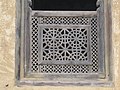
Girih tiling in buildings of Masuleh
[edit]_in_Traditional_Costume_-_Masouleh_-_Northwestern_Iran_-_02_(7420266658).jpg)
Girih tiling consists of straight and broken lines on a regular basis that could be reasonably expanded in the surface.[8]
The historical city of Masuleh is a good model for sustainable architecture and its final aim is respecting the culture and friendly relationship with nature and improving the life style of its residents.[9]
Archaeology
[edit]The earliest evidence of human presence in the Masouleh region, Iran, is a Levallois core from the Middle Paleolithic, likely made by Neanderthals over 40,000 years ago. This highlights Neanderthal activity in the area.[10] Archaeological survey of the mountain ranges overlooking Masouleh shows that this mountainous region was probably occupied by ancient herders and nomads at least since the late Bronze Age.[11]
Remains of late prehistoric, historic, and Islamic times were discovered on the mountain top above 2500 meters above sea level(See). These mountains were used seasonally, at least since the late Neolithic (5000 BC) Bronze Age (2000-1500 BC), which continued during the Iron Age I (1500-1100 BC), Iron Age III (800-500 BC), Parthian (247 BC to 224 CE), Buyid (943–1029 CE), Seljuk (1043–1051 CE) and Ilkhanid (1306–1335 CE) eras (tehrantimes).
Archaeologists discovered pottery sherds, animal bones, and stone tools that date back to about 7,000 years ago. [12]
Studies of the last one or two decades have provided very important information about the historical origin and physical changes and development of the cultural landscape of Masouleh. Studies by the Gilan Archaeological Center and the National Museum of Iran showed that Masouleh has undergone significant changes due to advances in sponge iron smelting technology. This became especially important with the two seasons of studies by the Iran and China groups, because the examples of sponge iron smelting furnaces in Masouleh had special forms and were of a multi-stage type that are almost unique in the region. The four-stage sponge smelting furnaces, the first examples of which probably formed in the late Parthian period, and expanded significantly in the Islamic periods, especially from the Ilkhanate period. These furnaces later spread to the Hyrcanian region and became known as Persian furnaces.[14]/[15] Since 2022, in-depth studies have been conducted on archaeological sites located in the Masouleh Cultural Landscape in collaboration with the Chinese Academy of Archaeology and the National Museum of Iran. These studies aimed to identify the early kilns and the origin of the multi-stage kilns found in the kohneh Masouleh. The identification and excavations on sites such as Khanbaji Sara / Gilvand Rood / Kore Bar by this international joint group showed that from the beginning of the Islamic period to the Seljuk period, there were a variety of single-stage kilns and early multi-stage examples in these areas. Sassanid and Parthian pottery samples were also found in this area, indicating that the establishment of early industrial workshops probably continued even into the historical period. The industrial workshop sites of sponge iron smelting in the Masouleh Cultural Landscape are gathered like moons around the historical city of Masouleh (like the sun). The city of Masouleh is an excellent example of a city construction and development influenced by the activities of the sponge iron smelting industry. Studies on the multi-stage furnaces found in the kohneh Masuleh region and also the examples found near the historical city of Masuleh show that these furnaces are a serious innovation and development in the history of the development of the sponge iron smelting industry. The Hyrcanian forest land of Masuleh, along with the specific geographical and climatic features and the special winds of this region and the historical conditions after the Mongol invasion of Iran, have been cited as the source of this serious transformation in the cultural landscape of Masuleh.<Ref: International Conference on History and Civilization of Guilan, 2025/ Tehran/ National Museum of Iran. Book of Collection of Articles/ pp. 200-220/ Ministry of Cultural Heritage, Tourism and Handicrafts)>
Tourism areas
[edit]Waterfalls: Kooshm, Larcheshme, and Kourbar.[13]
Gallery
[edit]-
 Window of building in Masuleh
 -
 The yard of the above building is the roof of the below building
 -
 The nature of Masuleh
 -
 Buildings are mostly 2 stories
 -


_006.jpg)
See also
[edit]![]() Media related to Masuleh at Wikimedia Commons
Media related to Masuleh at Wikimedia Commons
Notes
[edit]- ^ Also romanized as Masouleh and Māsūleh; also known as Masoleh;[3] historical names for the city include Khortāb and Māsalar[citation needed]
References
[edit]- ^ OpenStreetMap contributors (12 October 2024). "Masuleh, Fuman County" (Map). OpenStreetMap (in Persian). Retrieved 12 October 2024.
- ^ a b Census of the Islamic Republic of Iran, 1395 (2016): Gilan Province. amar.org.ir (Report) (in Persian). The Statistical Center of Iran. Archived from the original (Excel) on 4 December 2020. Retrieved 19 December 2022.
- ^ Masuleh can be found at GEOnet Names Server, at this link, by opening the Advanced Search box, entering "-3074349" in the "Unique Feature Id" form, and clicking on "Search Database".
- ^ Census of the Islamic Republic of Iran, 1385 (2006): Gilan Province. amar.org.ir (Report) (in Persian). The Statistical Center of Iran. Archived from the original (Excel) on 20 September 2011. Retrieved 25 September 2022.
- ^ Census of the Islamic Republic of Iran, 1390 (2011): Gilan Province. irandataportal.syr.edu (Report) (in Persian). The Statistical Center of Iran. Archived from the original (Excel) on 8 October 2023. Retrieved 19 December 2022 – via Iran Data Portal, Syracuse University.
- ^ "Monthly total of precipitation for Masuleh (99281)". data.irimo.ir (XLS download) (in Persian). Iran Meteorological Organization.
- ^ Sotoudeh, Manouchehr. "Monuments OF GĪLĀN". Encyclopædia Iranica. Retrieved 19 November 2011.
- ^ Sattari Sarbangholi, H., & Hasanpour loumer, S. (2015). The Ornamentations of Girih Tiling in Buildings of the Khanebar Neighborhood in Masouleh. HONAR-HA-YE-ZIBA HONAR-HA-YE-TAJASSOMI, 19(4), autumn, 55-66.
- ^ Hasanpour loumer, Saeid. "A Study on Decorations (Chinese Knotting) Used in Monuments of Masouleh Historical City, Case Study: Kasha-Sar Olia." the scientific-research degree of Armanshahr journal 9.17 (2017): 25-36. http://www.armanshahrjournal.com/article_44601.html. Web. 21 Apr. 2017. <http://www.armanshahrjournal.com/article_44601_d67ce62e2560b3fb2d9f0eac1aad57f8.pdf>.
- ^ https://www.actu-culture.com/archeologie/vestiges-paleolithiques-dans-les-montagnes-de-talych-en-iran/
- ^ Biglari, F., M. Akbari 2022.L’homme et le paysage de montagne dans l’Elbourz, ARCHAEOLGIA, 608:16-17.
- ^ "Discovery of 7K years old early herders' camp on Mountaintop near Masouleh, Gilan". 28 September 2022.
- ^ "masuleh in iran". January 2019.
13. Pourali Mostafa and Mansour Falamaki 2015. Understanding Territories, Case Study: MASOULEH, in kashan University press, http://jias.kashanu.ac.ir
14. Preliminary Report on Iran and China Studies / Masouleh : ...................... https://mp.weixin.qq.com/s?__biz=MjM5ODI3NzkzOQ==&mid=2651688139&idx=1&sn=ae644ab0dc74764909bb7221ba5c1d72&chksm=bc61f3265d456679cfad352a06b900c2b62f26d367a0e189b1650b27a64efd041af175521533&mpshare=1&srcid=0718UbcdUbTj7DbAclh39kyR&sharer_shareinfo=952225054562a9d831cdc9d53775dc34&sharer_shareinfo_first=d02764fd1c38b88487aa69d1c81194f1&from=singlemessage&scene=1&subscene=317&sessionid=1753167197&clicktime=1753171580&enterid=1753171580&ascene=1&fasttmpl_type=0&fasttmpl_fullversion=7830194-en_US-zip&fasttmpl_flag=0&realreporttime=1753171580610#rd ........................ https://www.tehrantimes.com/news/513885/Second-phase-of-Iran-China-studies-launches-in-Masouleh-to-examine
External links
[edit]- Masuleh Pictures
- HORIZIN, Masuleh, Photo Set, flikr
- Iran Cultural Heritage, Handicrafts and Tourism Organization: [1]
- WiseItinerary
| Capital |  | |
|---|---|---|
| Counties and cities | ||
| Sights |
| |
| Populated places | ||