Julesburg, Colorado
Julesburg, Colorado | |
|---|---|
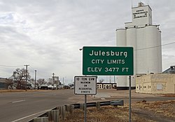
 Entering Julesburg from northeast (2017) | |
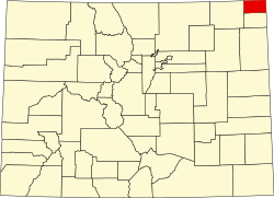
 Location within Sedgwick County and Colorado | |
| Coordinates: 40°59′18″N 102°16′0″W / 40.98833°N 102.26667°W[2] | |
| Country | United States |
| State | Colorado |
| County | Sedgwick County Seat[1] |
| Incorporated | November 18, 1886[3] |
| Named after | Jules Beni |
| Area | |
• Total | 1.51 sq mi (3.92 km2) |
| • Land | 1.51 sq mi (3.92 km2) |
| • Water | 0.00 sq mi (0.00 km2) |
| Elevation | 3,478 ft (1,060 m) |
| Population | |
• Total | 1,307 |
| • Density | 870/sq mi (330/km2) |
| Time zone | UTC−7 (MST) |
| • Summer (DST) | UTC−6 (MDT) |
| ZIP Code | 80737[6] |
| Area code | 970 |
| FIPS code | 08-39965 [2] |
| GNIS ID | 202892 [2] |
| Website | townofjulesburg.com |
Julesburg is the statutory town that is the county seat of and the most populous municipality in Sedgwick County, Colorado, United States.[2] The population was 1,307 at the 2020 United States census.[5]
History
[edit]The original trading post was named for Jules Beni.[7] Julesburg was on the Pony Express (1860–1861) route from Missouri to California.
Jack Slade
[edit]
In 1858, Joseph A. "Jack" Slade, a superintendent for the Central Overland California and Pikes Peak Express Company, was tracking down horse thieves, including Jules Beni. Slade caught up with him at Julesburg, but Beni shot him five times. Thinking that Slade was dead, several angry townsfolk chased Beni out of Julesburg. When they returned, they found Slade struggling to his feet, having miraculously survived.
Beni continued to steal horses from the Pike's Peak Express Company, and Slade vowed to hunt him down. Beni attempted to ambush Slade at Slade's own ranch at Cold Springs. But Slade found out about the planned ambush and, along with some of his cowboys, captured Beni. Slade did not take Beni to authorities but instead shot him dead while he was tied to a fence post.[8] He shot off each of Beni's fingers, then put the gun in Beni's mouth and pulled the trigger. Afterward, he severed Beni's ears as trophies.[citation needed]
Battle of Julesburg
[edit]Julesburg was a large and prominent stagecoach station and the site of Fort Rankin (later Fort Sedgwick). In revenge for the Sand Creek Massacre, one thousand Cheyenne, Arapaho, and Lakota warriors attacked Julesburg on January 7, 1865. In the battle the Indians defeated about 60 soldiers of the U.S. Army and 50 armed civilians. In the following weeks the Indians raided up and down the South Platte River valley. On February 2 they returned to Julesburg and burned down all the buildings in the settlement, although not attacking the soldiers and civilians holed up in the fort. At the time, the town was said to have had over 1000 buildings.[9]
Union Pacific
[edit]In 1867, during the building of the Union Pacific transcontinental railroad, Julesburg served as an "end-of-track" town, where railroad workers would live while not laboring. At that time, about 4,000 workers inhabited the town, which had grown numerous saloons and gambling tents to serve them.[10]
Such towns were generally very violent places. A colonel in the U.S Army stationed in Julesburg, Richard Irving Dodge, reported that of 127 graves he saw there, only six of those buried had died of natural causes. This worked out to one violent death for every day of the town's lifespan to that point. Many had been killed by vigilance committees, lynched and hung from the telegraph poles of the Union Pacific.[10]
As the railroad advanced into Wyoming, new towns such as Cheyenne sprung up to house and service its workers. According to historian David T. Courtwright, end-of-track towns like Julesburg, Cheyenne and others were "agglomeration[s] (the word "community" is not appropriate) of young, transient, expendable, bachelor laborers whose self-image was one of toughness and whose unregulated vices attracted criminals, gamblers, prostitutes, and other armed opportunists eager to siphon off their wages." This mix created the environment that allowed the deadly violence of such places to thrive.[10]
Geography
[edit]Julesburg is located at 40°59′18″N 102°16′0″W / 40.98833°N 102.26667°W (40.988422, −102.266677).[11] According to the United States Census Bureau, the town has a total area of 1.3 square miles (3.4 km2), all of it land.
The town is located on the north side of the South Platte River, along U.S. 138 and U.S. 385 and just off of I-76. It is the northernmost town in the state, less than 0.9 mi (1.4 km) south of the Colorado−Nebraska state line.
Climate
[edit]Julesburg has a semi-arid climate (Köppen BSk) with cold, dry winters and hot, wetter summers.
| Climate data for Julesburg, Colorado, 1991–2020 normals, extremes 1893–present | |||||||||||||
|---|---|---|---|---|---|---|---|---|---|---|---|---|---|
| Month | Jan | Feb | Mar | Apr | May | Jun | Jul | Aug | Sep | Oct | Nov | Dec | Year |
| Record high °F (°C) | 74 (23) |
79 (26) |
88 (31) |
94 (34) |
100 (38) |
107 (42) |
109 (43) |
109 (43) |
106 (41) |
95 (35) |
85 (29) |
77 (25) |
109 (43) |
| Mean maximum °F (°C) | 63.4 (17.4) |
67.7 (19.8) |
77.9 (25.5) |
83.6 (28.7) |
91.9 (33.3) |
97.6 (36.4) |
100.8 (38.2) |
96.7 (35.9) |
95.4 (35.2) |
86.6 (30.3) |
74.8 (23.8) |
61.6 (16.4) |
101.4 (38.6) |
| Mean daily maximum °F (°C) | 40.5 (4.7) |
44.0 (6.7) |
54.5 (12.5) |
61.9 (16.6) |
70.7 (21.5) |
81.5 (27.5) |
87.6 (30.9) |
85.3 (29.6) |
78.3 (25.7) |
64.5 (18.1) |
51.2 (10.7) |
40.5 (4.7) |
63.4 (17.4) |
| Daily mean °F (°C) | 28.2 (−2.1) |
31.1 (−0.5) |
40.2 (4.6) |
48.3 (9.1) |
57.7 (14.3) |
68.4 (20.2) |
74.4 (23.6) |
72.1 (22.3) |
63.6 (17.6) |
49.9 (9.9) |
37.6 (3.1) |
28.3 (−2.1) |
50.0 (10.0) |
| Mean daily minimum °F (°C) | 15.9 (−8.9) |
18.2 (−7.7) |
25.9 (−3.4) |
34.6 (1.4) |
44.7 (7.1) |
55.3 (12.9) |
61.3 (16.3) |
58.9 (14.9) |
48.8 (9.3) |
35.3 (1.8) |
24.0 (−4.4) |
16.0 (−8.9) |
36.6 (2.5) |
| Mean minimum °F (°C) | −5.4 (−20.8) |
−2.5 (−19.2) |
8.0 (−13.3) |
19.7 (−6.8) |
29.2 (−1.6) |
43.6 (6.4) |
51.4 (10.8) |
48.5 (9.2) |
35.3 (1.8) |
16.9 (−8.4) |
5.4 (−14.8) |
−4.2 (−20.1) |
−12.0 (−24.4) |
| Record low °F (°C) | −34 (−37) |
−30 (−34) |
−23 (−31) |
−8 (−22) |
19 (−7) |
32 (0) |
35 (2) |
38 (3) |
16 (−9) |
−3 (−19) |
−14 (−26) |
−38 (−39) |
−38 (−39) |
| Average precipitation inches (mm) | 0.41 (10) |
0.41 (10) |
1.00 (25) |
1.77 (45) |
3.00 (76) |
3.20 (81) |
2.33 (59) |
2.79 (71) |
1.52 (39) |
1.43 (36) |
0.41 (10) |
0.29 (7.4) |
18.56 (469.4) |
| Average snowfall inches (cm) | 3.7 (9.4) |
4.0 (10) |
3.3 (8.4) |
2.3 (5.8) |
0.1 (0.25) |
0.0 (0.0) |
0.0 (0.0) |
0.0 (0.0) |
0.0 (0.0) |
2.0 (5.1) |
2.8 (7.1) |
3.5 (8.9) |
21.7 (54.95) |
| Average precipitation days (≥ 0.01 in) | 1.5 | 2.5 | 3.9 | 5.7 | 8.1 | 7.9 | 7.0 | 6.8 | 4.7 | 4.6 | 2.3 | 1.3 | 56.3 |
| Average snowy days (≥ 0.1 in) | 1.8 | 2.2 | 1.5 | 1.1 | 0.1 | 0.0 | 0.0 | 0.0 | 0.0 | 0.8 | 1.3 | 1.7 | 10.5 |
| Source 1: NOAA[12] | |||||||||||||
| Source 2: National Weather Service[13] | |||||||||||||
Demographics
[edit]| Census | Pop. | Note | %± |
|---|---|---|---|
| 1890 | 202 | — | |
| 1900 | 371 | 83.7% | |
| 1910 | 962 | 159.3% | |
| 1920 | 1,320 | 37.2% | |
| 1930 | 1,467 | 11.1% | |
| 1940 | 1,619 | 10.4% | |
| 1950 | 1,951 | 20.5% | |
| 1960 | 1,840 | −5.7% | |
| 1970 | 1,578 | −14.2% | |
| 1980 | 1,528 | −3.2% | |
| 1990 | 1,295 | −15.2% | |
| 2000 | 1,467 | 13.3% | |
| 2010 | 1,225 | −16.5% | |
| 2020 | 1,307 | 6.7% |
Education
[edit]The Julesburg School District operates public schools.
In popular culture
[edit]- The Jack Slade acount above appeared on an episode of Stories of the Century – a syndicated television series starring and narrated by Jim Davis – which aired on March 4, 1955. Gregg Palmer played the role of Slade, and Paul Newlan portrayed Beni.
- "Julesburg" is the title of the second episode (1955) of the ABC western Cheyenne.[14]
- The town was the setting of the 1959 Randolph Scott film, Westbound.
- Julesburg was featured in the 1960 episode "The Story of Julesburg" of the syndicated television series Pony Express.[15]
- A 2019 YouTube video by Voice of America News features Julesburg as the backdrop for a short documentary about Charmaine Teodoro, a math teacher from the Philippines who is currently working at Julesburg High School.[16]
See also
[edit]References
[edit]- ^ "Active Colorado Municipalities". State of Colorado, Department of Local Affairs. Archived from the original on December 12, 2009. Retrieved September 1, 2007.
- ^ a b c d e "Julesburg, Colorado", Geographic Names Information System, United States Geological Survey, United States Department of the Interior
- ^ "Colorado Municipal Incorporations". State of Colorado, Department of Personnel & Administration, Colorado State Archives. December 1, 2004. Retrieved September 2, 2007.
- ^ "2019 U.S. Gazetteer Files". United States Census Bureau. Retrieved July 1, 2020.
- ^ a b United States Census Bureau. "Julesburg town; Colorado". Retrieved April 20, 2023.
- ^ "ZIP Code Lookup". United States Postal Service. Archived from the original (JavaScript/HTML) on November 4, 2010. Retrieved October 17, 2007.
- ^ Dawson, John Frank. Place names in Colorado: why 700 communities were so named, 150 of Spanish or Indian origin. Denver, CO: The J. Frank Dawson Publishing Co. p. 28. Archived from the original on November 8, 2016.
- ^ Colorado Heritage (Autumn 2000) p.48
- ^ Grinnell, George Bird (1916) The Fighting Cheyennes. New York: Charles Scribner's Sons, pp. 181-195
- ^ a b c Courtwright, David T. (1996) Violent Land: Single Men and Social Disorder From the Frontier to the Inner City. Cambridge, Massachusetts: Harvard University Press. pp.83-84. ISBN 0-674-27871-2
- ^ "US Gazetteer files: 2010, 2000, and 1990". United States Census Bureau. February 12, 2011. Retrieved April 23, 2011.
- ^ "U.S. Climate Normals Quick Access". National Oceanic and Atmospheric Administration. Retrieved August 8, 2022.
- ^ "NOAA Online Weather Data". National Weather Service. Retrieved August 8, 2022.
- ^ "Julesburg". Internet Movie Database. October 11, 1955. Retrieved December 2, 2014.
- ^ "Pony Express". Classic Television Archives. Retrieved January 30, 2013.
- ^ "Foreign Teacher Lands in Rural America: 'I Was Surprised'", VOA Connect, 2019. Retrieved November 1, 2020]


