
Center, Colorado
Center, Colorado | |
|---|---|
| Town of Center[1] | |
 Center in winter, December 2012 | |
 | |
 Center Location of the Town of Center, Colorado.  Center Center (Colorado) | |
| Coordinates: 39°00′00″N 102°00′00″W / 39.0000°N 102.0000°W[3] | |
| Country | United States |
| State | Colorado |
| Counties[2] | Saguache Rio Grande |
| Incorporated | January 18, 1907[4] |
| Government | |
| • Type | statutory town[1] |
| Area | |
• Total | 0.864 sq mi (2.238 km2) |
| • Land | 0.864 sq mi (2.238 km2) |
| • Water | 0.000 sq mi (0.000 km2) |
| Elevation | 7,645 ft (2,330 m) |
| Population | |
• Total | 1,929 |
| • Density | 2,232/sq mi (862/km2) |
| Time zone | UTC−07:00 (MST) |
| • Summer (DST) | UTC−06:00 (MDT) |
| ZIP code[6] | 81125 |
| Area code | 719 |
| GNIS pop ID | 203419 |
| GNIS town ID | 2413186 |
| FIPS code | 08-12855 |
| Website | www |
Center is a statutory town located in Saguache and Rio Grande counties, Colorado, United States.[1] The town's population was 1,929 at the 2020 United States census with 1,885 residing in Saguache County and 44 residing in Rio Grande County.[5]
History
[edit]The Centerview, Colorado, post office opened on April 22, 1898, but the name of the post office was changed to Center, Colorado, on July 1, 1899.[7] The Town of Center was incorporated on January 18, 1907.[1] The town lies near the center of the San Luis Valley, hence the name.[8]
Facilities
[edit]
Leach Airport is located 4 miles east and 3 miles north of town, at County Road 53 and County Road C.[9] The nearest college is Adams State College; 23 miles to Alamosa, Colorado.
Geography
[edit]At the 2020 United States census, the town had a total area of 553 acres (2.238 km2), all of it land.[5]
Climate
[edit]Center has a cold desert climate (Köppen BWk), bordering on a cold semi-arid climate (Köppen BSk).
| Climate data for Center 4 SSW, Colorado, 1991–2020 normals, 1941-2020 records: 7,673 ft (2,339 m) | |||||||||||||
|---|---|---|---|---|---|---|---|---|---|---|---|---|---|
| Month | Jan | Feb | Mar | Apr | May | Jun | Jul | Aug | Sep | Oct | Nov | Dec | Year |
| Record high °F (°C) | 59 (15) |
65 (18) |
74 (23) |
83 (28) |
88 (31) |
95 (35) |
94 (34) |
90 (32) |
89 (32) |
81 (27) |
68 (20) |
61 (16) |
95 (35) |
| Mean maximum °F (°C) | 46.6 (8.1) |
52.2 (11.2) |
65.4 (18.6) |
72.5 (22.5) |
79.7 (26.5) |
87.3 (30.7) |
88.4 (31.3) |
86.2 (30.1) |
81.9 (27.7) |
74.6 (23.7) |
61.3 (16.3) |
50.0 (10.0) |
89.6 (32.0) |
| Mean daily maximum °F (°C) | 31.6 (−0.2) |
38.0 (3.3) |
49.4 (9.7) |
58.1 (14.5) |
66.8 (19.3) |
76.3 (24.6) |
79.8 (26.6) |
78.5 (25.8) |
72.9 (22.7) |
60.8 (16.0) |
46.1 (7.8) |
33.4 (0.8) |
57.6 (14.2) |
| Daily mean °F (°C) | 17.9 (−7.8) |
24.0 (−4.4) |
34.8 (1.6) |
42.7 (5.9) |
51.5 (10.8) |
59.3 (15.2) |
63.8 (17.7) |
62.4 (16.9) |
56.2 (13.4) |
44.7 (7.1) |
31.3 (−0.4) |
19.2 (−7.1) |
42.3 (5.7) |
| Mean daily minimum °F (°C) | 4.2 (−15.4) |
10.0 (−12.2) |
20.2 (−6.6) |
27.3 (−2.6) |
36.2 (2.3) |
42.3 (5.7) |
47.7 (8.7) |
46.3 (7.9) |
39.5 (4.2) |
28.5 (−1.9) |
16.5 (−8.6) |
5.0 (−15.0) |
27.0 (−2.8) |
| Mean minimum °F (°C) | −12.7 (−24.8) |
−9.3 (−22.9) |
3.6 (−15.8) |
13.7 (−10.2) |
24.3 (−4.3) |
33.1 (0.6) |
40.5 (4.7) |
39.0 (3.9) |
27.9 (−2.3) |
14.3 (−9.8) |
−1.6 (−18.7) |
−12.8 (−24.9) |
−17.5 (−27.5) |
| Record low °F (°C) | −40 (−40) |
−32 (−36) |
−16 (−27) |
−4 (−20) |
12 (−11) |
23 (−5) |
31 (−1) |
28 (−2) |
16 (−9) |
−4 (−20) |
−25 (−32) |
−41 (−41) |
−41 (−41) |
| Average precipitation inches (mm) | 0.13 (3.3) |
0.27 (6.9) |
0.33 (8.4) |
0.53 (13) |
0.58 (15) |
0.63 (16) |
1.32 (34) |
1.19 (30) |
0.70 (18) |
0.61 (15) |
0.46 (12) |
0.46 (12) |
7.21 (183.6) |
| Average snowfall inches (cm) | 3.50 (8.9) |
2.90 (7.4) |
5.50 (14.0) |
1.80 (4.6) |
0.60 (1.5) |
0.00 (0.00) |
0.00 (0.00) |
0.00 (0.00) |
0.00 (0.00) |
1.60 (4.1) |
3.10 (7.9) |
6.10 (15.5) |
25.1 (63.9) |
| Average precipitation days (≥ 0.01 in) | 2.2 | 2.2 | 2.9 | 3.3 | 4.4 | 5.0 | 7.5 | 9.3 | 6.4 | 4.3 | 3.0 | 2.7 | 53.2 |
| Average snowy days (≥ 0.1 in) | 2.0 | 1.5 | 2.0 | 0.7 | 0.2 | 0.0 | 0.0 | 0.0 | 0.0 | 0.4 | 1.5 | 1.7 | 10 |
| Source 1: NOAA[10] | |||||||||||||
| Source 2: XMACIS2 (records & monthly max/mins)[11] | |||||||||||||
Demographics
[edit]| Census | Pop. | Note | %± |
|---|---|---|---|
| 1910 | 385 | — | |
| 1920 | 547 | 42.1% | |
| 1930 | 1,011 | 84.8% | |
| 1940 | 1,515 | 49.9% | |
| 1950 | 2,024 | 33.6% | |
| 1960 | 1,600 | −20.9% | |
| 1970 | 1,470 | −8.1% | |
| 1980 | 1,630 | 10.9% | |
| 1990 | 1,963 | 20.4% | |
| 2000 | 2,392 | 21.9% | |
| 2010 | 2,230 | −6.8% | |
| 2020 | 1,929 | −13.5% | |
| U.S. Decennial Census | |||
As of the census[12] of 2012, there were 2,271 people, 768 households, and 603 families residing in the town. The population density was 2,854.3 inhabitants per square mile (1,102.1/km2). There were 848 housing units at an average density of 1,011.9 units per square mile (390.7 units/km2). The racial makeup of the town was 10.3% White, 0.3% African American, 1% Native American, 0.09% from other races, and 0.09% from two or more races. Hispanic or Latino of any race were 87.4% of the population.
There were 768 households, out of which 47.8% had children under the age of 18 living with them, 56.3% were married couples living together, 17.4% had a female householder with no husband present, and 21.4% were non-families. 18.2% of all households were made up of individuals, and 7.8% had someone living alone who was 65 years of age or older. The average household size was 3.11 and the average family size was 3.56.
In the town, the population was spread out, with 35.2% under the age of 18, 11.1% from 18 to 24, 27.4% from 25 to 44, 17.0% from 45 to 64, and 9.3% who were 65 years of age or older. The median age was 28 years. For every 100 females, there were 99.2 males. For every 100 females age 18 and over, there were 96.8 males.
The median income for a household in the town was $23,780, and the median income for a family was $26,143. Males had a median income of $20,844 versus $18,036 for females. The per capita income for the town was $9,289. About 27.1% of families and 27.5% of the population were below the poverty line, including 31.6% of those under age 18 and 22.8% of those age 65 or over.
Education
[edit]- Public high schools:
- Center High School - grades 9 - 12
- The Academic Recovery Center of San Luis Valley - grades 9 - 12
- Public elementary/middle schools:
- Haskin Elementary School
- Skoglund Middle School - grades 6 - 8
- Private elementary/middle school in Center:
- High Valley Christian School
See also
[edit]- List of municipalities in Colorado
- List of populated places in Colorado
- List of post offices in Colorado
References
[edit]- ^ a b c d e "Active Colorado Municipalities". Colorado Department of Local Affairs. Retrieved June 9, 2025.
- ^ "Colorado Counties". Colorado Department of Local Affairs. Retrieved June 9, 2025.
- ^ a b "Center, Colorado". Geographic Names Information System. United States Geological Survey, United States Department of the Interior. Retrieved June 9, 2025.
- ^ "Colorado Municipal Incorporations". State of Colorado, Department of Personnel & Administration, Colorado State Archives. December 1, 2004. Archived from the original on August 23, 2003. Retrieved September 2, 2007.
- ^ a b c d "Decennial Census P.L. 94-171 Redistricting Data". United States Census Bureau, United States Department of Commerce. August 12, 2021. Retrieved September 4, 2021.
- ^ "ZIP Code Lookup". United States Postal Service. Retrieved June 9, 2025.
- ^ Bauer, William H.; Ozment, James L.; Willard, John H. (1990). Colorado Post Offices 1859–1989. Golden, Colorado: Colorado Railroad Historical Foundation. ISBN 0-918654-42-4.
- ^ Dawson, John Frank (1954). Place names in Colorado: why 700 communities were so named, 150 of Spanish or Indian origin. Denver, CO: The J. Frank Dawson Publishing Co. p. 13.
- ^ Google.com: Leach Airport Map and Data
- ^ "Center 4 SSW, Colorado 1991-2020 Monthly Normals". Retrieved January 7, 2024.
- ^ "xmACIS". National Oceanic and Atmospheric Administration. Retrieved January 7, 2024.
- ^ "U.S. Census website". United States Census Bureau. Retrieved January 31, 2008.
External links
[edit]Municipalities and communities of Saguache County, Colorado, United States | ||
|---|---|---|
| Towns | 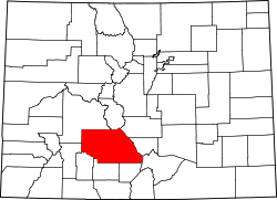 | |
| Unincorporated communities | ||
| Ghost towns | ||
| Footnotes | ‡This populated place also has portions in an adjacent county or counties | |
Municipalities and communities of Rio Grande County, Colorado, United States | ||
|---|---|---|
| City |  | |
| Towns | ||
| CDPs | ||
| Unincorporated community | ||
| ghost town | ||
| Footnotes | ‡This populated place also has portions in an adjacent county or counties | |
| International | |
|---|---|
| National | |