
Vujnovići
Vujnovići
| |
|---|---|
Village | |
 Vujnovići | |
| Coordinates: 45°22′15″N 15°03′45″E / 45.37072°N 15.062499°E | |
| Country | |
| County | Primorje-Gorski Kotar County |
| City | Vrbovsko |
| Area | |
• Total | 27.6 km2 (10.7 sq mi) |
| Population (2021)[3] | |
• Total | 32 |
| • Density | 1.2/km2 (3.0/sq mi) |
| Time zone | UTC+1 (CET) |
| • Summer (DST) | UTC+2 (CEST) |
| Postal code | 51326 |
| Area code | +385 051 |
Vujnovići is a village in Croatia, under the Vrbovsko township, in Primorje-Gorski Kotar County. The Kamačnik canyon and Kamačnik Bridge over it are both within the territory of Vujnovići.
History
[edit]Towards the end of WWII, after the success of a certain Partisan offensive, Vrbovsko postal telephone operator Anka Paviša, wife of Matija Paviša, overheard a conversation of some of the "occupiers" indicating they planned to exact revenge for that success on the Serb inhabitants of Vujnovići. According to Mladen Marušić, Anka was able to warn them of this beforehand and no one perished. After the war, Anka was made post office manager.[4]
Demographics
[edit]| population | 432 | 528 | 255 | 247 | 247 | 190 | 152 | 161 | 72 | 81 | 100 | 92 | 86 | 83 | 54 | 41 | 32 |
| 1857 | 1869 | 1880 | 1890 | 1900 | 1910 | 1921 | 1931 | 1948 | 1953 | 1961 | 1971 | 1981 | 1991 | 2001 | 2011 | 2021 |
Politics
[edit]As of its foundation on 3 March 2008, it belongs to the local committee of Vrbovsko.[5]
Attractions
[edit]Kamačnik canyon
[edit]The Kamačnik river is a right tributary of the Dobra that runs through a canyon covered in dense beech forest. Kamačnik canyon gained legal protection in 2002 by decision of the Županijska skupština of Primorje-Gorski Kotar County, which can be found in the Službene novine Primorsko-goranske županije issue 23/2002.[6]
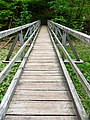
The 3 kilometres (1.9 mi) tourist path along the Kamačnik river was made in the second half of the 20th century, commissioned by the Tourist Society (Croatian: Turističko društvo). The path winds back and forth from one bank to the other over a series of wooden bridges all the way to the source at a Vauclusian spring.[6]
At the beginning of the 20th century, a sawmill was built near the mouth of the canyon, but it was in ruins by the time the park was declared in 2002.[6]
The restaurant in Kamačnik was broken into and robbed in November 2014 together with the Gavranović stores in Dokmanovići and Severin na Kupi.[7]
In 2016, a path was built connecting the Planinarski dom Kamačnik mountain hut with the Kamačnik canyon.[8]
In 2024, the final section of the path to the source was widened.[9]
-
 Source
 -
 Course
 -
 Bridge I
 -
 Bridge II
 -
 Bridge III
 -
 Vegetation


Infrastructure
[edit]The water storage unit Kratofil is responsible for Vujnovići and part of Vrbovsko.[10]
References
[edit]- ^ Government of Croatia (October 2013). "Peto izvješće Republike Hrvatske o primjeni Europske povelje o regionalnim ili manjinskim jezicima" (PDF) (in Croatian). Council of Europe. p. 36. Retrieved 30 November 2016.
- ^ Register of spatial units of the State Geodetic Administration of the Republic of Croatia. Wikidata Q119585703.
- ^ "Population by Age and Sex, by Settlements" (xlsx). Census of Population, Households and Dwellings in 2021. Zagreb: Croatian Bureau of Statistics. 2022.
- ^ Marušić, Mladen (2013-05-04). "GORSKA PISMA (ČITATELJA): I dvorce ubijaju, zar ne?". Gorske novosti.
- ^ Medved, Slavko (2008-03-14). "Statut Grada Vrbovskog (pročišćeni tekst)". Službene novine: Službeno glasilo Primorsko-goranske županije. Vol. 16, no. 8.
- ^ a b c Vahtar-Jurković, Koraljka; Obad Šćitaroci, Mladen (2017-12-31). "Pejsažno i perivojno naslijeđe Gorskoga kotara" [Landscape and Park Heritage of Gorski Kotar]. Prostor: znanstveni časopis za arhitekturu i urbanizam (in Croatian). 25 (2): 328–341. doi:10.31522/p.25.2(54).11.
- ^ Gorske novosti (2014-11-18). "Prijelomna vijest – krenuo val provalnih krađa: Uz Skrad i Kamačnik provaljeno i u dvije trgovine Gavranović na području Vrbovskog!". Gorske novosti.
- ^ Tatar, Nensi (2016-09-13). "Na "staroj cesti" u Vrbovskom: Radovi na zamjeni cjevovoda". Gorske novosti.
- ^ Tatar, Nensi (2013-09-29). "POČELI RADOVI: Širi se staza zadnjeg dijela kanjona". Gorske novosti.
- ^ Brinjak, Šein (2016-05-25). "Odluka o prihvaćanju izmjena i dopuna Procjene ugroženosti stanovništva, materijalnih i kulturnih dobara te okoliša od katastrofa i velikih nesreća za područje Grada Vrbovskog" (PDF). Službene novine Grada Vrbovskog. Vol. 2, no. 4. p. 23. ISSN 1849-6490.
Further reading
[edit]- Tomljenović, Renata (2009). Lujzijana: povijesno-turistička cesta. Opatija, 🖶 Zagreb: Turistička zajednica Primorsko-goranske županije, 🖶 Tipomat.
External links
[edit]Kamačnik
[edit]- Kamačnik at the Tourist board Gorski kotar site.
- Kamačnik Hiking Map by Molekula

This Primorje-Gorski Kotar County geography article is a stub. You can help Wikipedia by expanding it. |