Toporów, Lubusz Voivodeship
Appearance
Toporów | |
|---|---|
Village | |
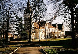
 Hunter's Palace | |
| Coordinates: 52°15′N 15°15′E / 52.250°N 15.250°E | |
| Country | |
| Voivodeship | Lubusz |
| Powiat | Świebodzin |
| Gmina | Łagów |
| Established | 13th century |
| Government | |
| • Mayor | Józef Aftyka |
| Population (2002) | |
• Total | 807 |
| Time zone | UTC+1 (CET) |
| • Summer (DST) | UTC+2 (CEST) |
| Postal code | 66-220 |
| Area code | +48 683411... |
| Vehicle registration | FZW |
Toporów [tɔˈpɔruf] is a village in the administrative district of Gmina Łagów, within Świebodzin County, Lubusz Voivodeship, in western Poland.[1] It lies approximately 8 km (5 mi) south of Łagów, 19 km (12 mi) west of Świebodzin, 40 km (25 mi) north-west of Zielona Góra, and 52 km (32 mi) south of Gorzów Wielkopolski.
Landmarks of Toporów are the Renaissance Revival-Gothic Revival Toporów Hunting Palace, the Our Lady of the Rosary church, and an over 700-year-old pedunculate oak with a circumference of 8.7 meters, growing near the church.[2]
Transport
[edit]The village is located on European route E30.
References
[edit]- ^ "Główny Urząd Statystyczny" [Central Statistical Office] (in Polish). Select Miejscowości (SIMC) tab, select fragment (min. 3 znaki), enter town name in the field below, click WYSZUKAJ (Search)
- ^ Lubuskie po drodze. Świat militariów i fortyfikacji (in Polish). Zielona Góra. p. 27. ISBN 978-83-8009-168-9.
Wikimedia Commons has media related to Toporów, Lubusz Voivodeship.


