
Seventh Mountain, Oregon
Seventh Mountain, Oregon | |
|---|---|
 Seventh Mountain Location within the state of Oregon  Seventh Mountain Seventh Mountain (the United States) | |
| Coordinates: 44°0′19″N 121°22′56″W / 44.00528°N 121.38222°W | |
| Country | United States |
| State | Oregon |
| County | Deschutes |
| Area | |
• Total | 1.94 sq mi (5.02 km2) |
| • Land | 1.94 sq mi (5.01 km2) |
| • Water | 0.01 sq mi (0.01 km2) |
| Elevation | 3,907 ft (1,191 m) |
| Population | |
• Total | 407 |
| • Density | 210.34/sq mi (81.21/km2) |
| Time zone | UTC-8 (Pacific) |
| • Summer (DST) | UTC-7 (Pacific) |
| ZIP code | 97702[3] |
| Area code(s) | 458 and 541 |
| FIPS code | 41-66385 |
| GNIS feature ID | 2584422[4] |
Seventh Mountain is an unincorporated community and census-designated place (CDP) in Deschutes County, in the U.S. state of Oregon.[4] The community lies along the west bank of the Deschutes River southwest of Bend.[5]
Century Drive Highway, part of the Cascade Lakes Scenic Byway, connects Bend to Seventh Mountain. From Seventh Mountain, the byway runs west to Mount Bachelor and its ski area.[5] The CDP is closely associated with the Seventh Mountain Resort, which includes 21 lodging buildings with more than 200 condominiums.[6]
As of the 2010 Census, the population was 187,[7] over an area of 2.0 square miles (5.1 km2).[7]
Demographics
[edit]| Census | Pop. | Note | %± |
|---|---|---|---|
| 2020 | 407 | — | |
| U.S. Decennial Census[8][2] | |||
Education
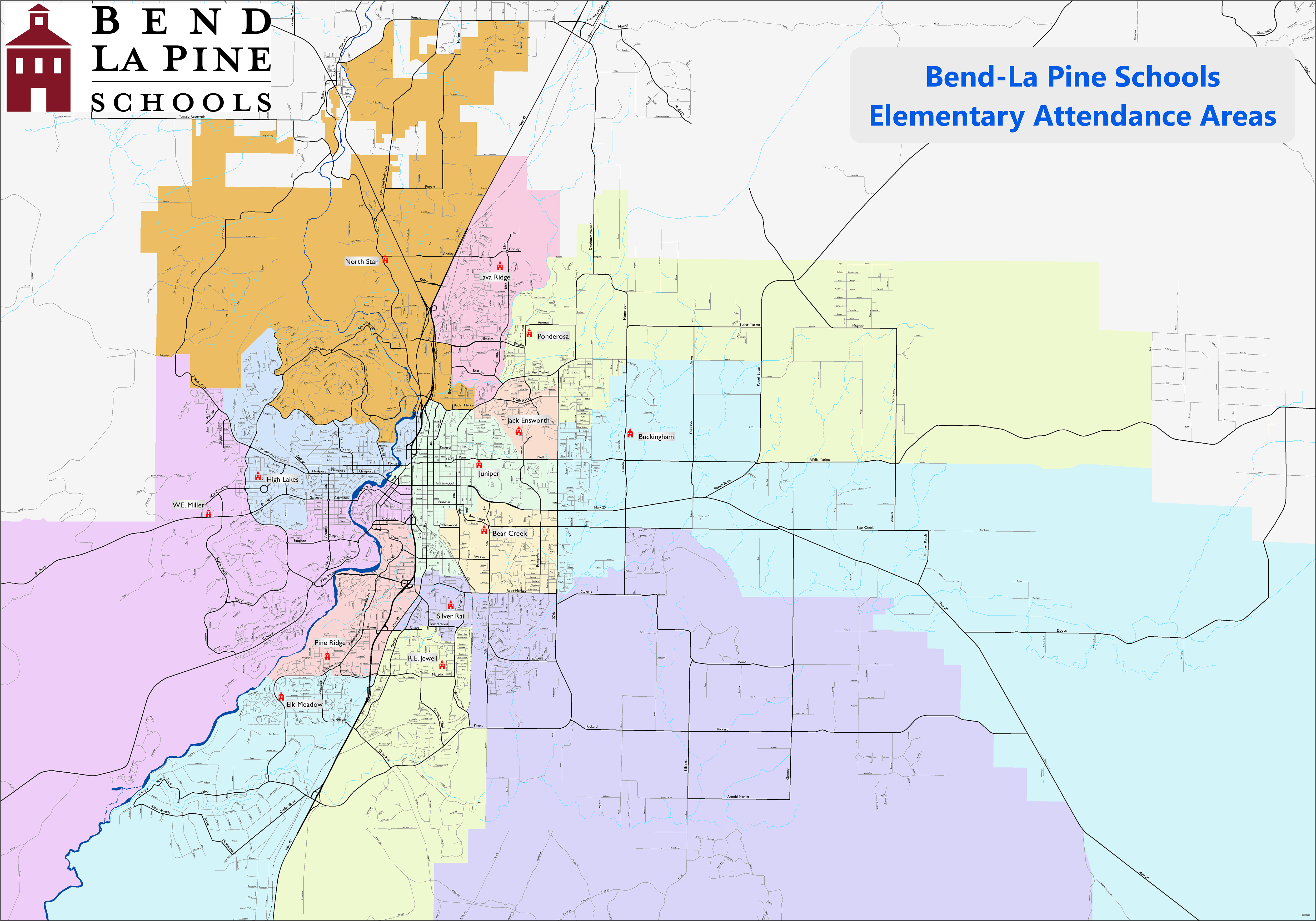
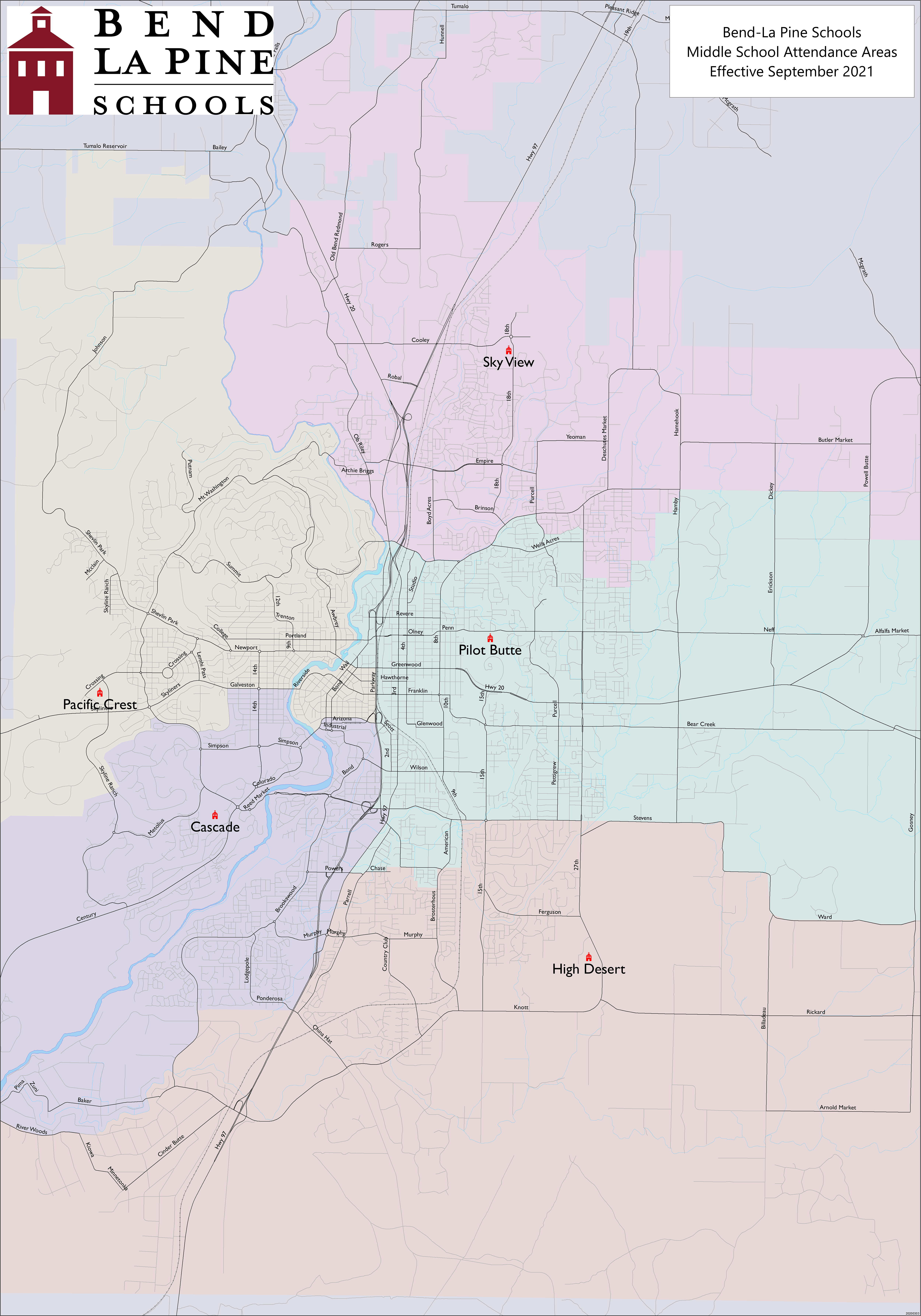
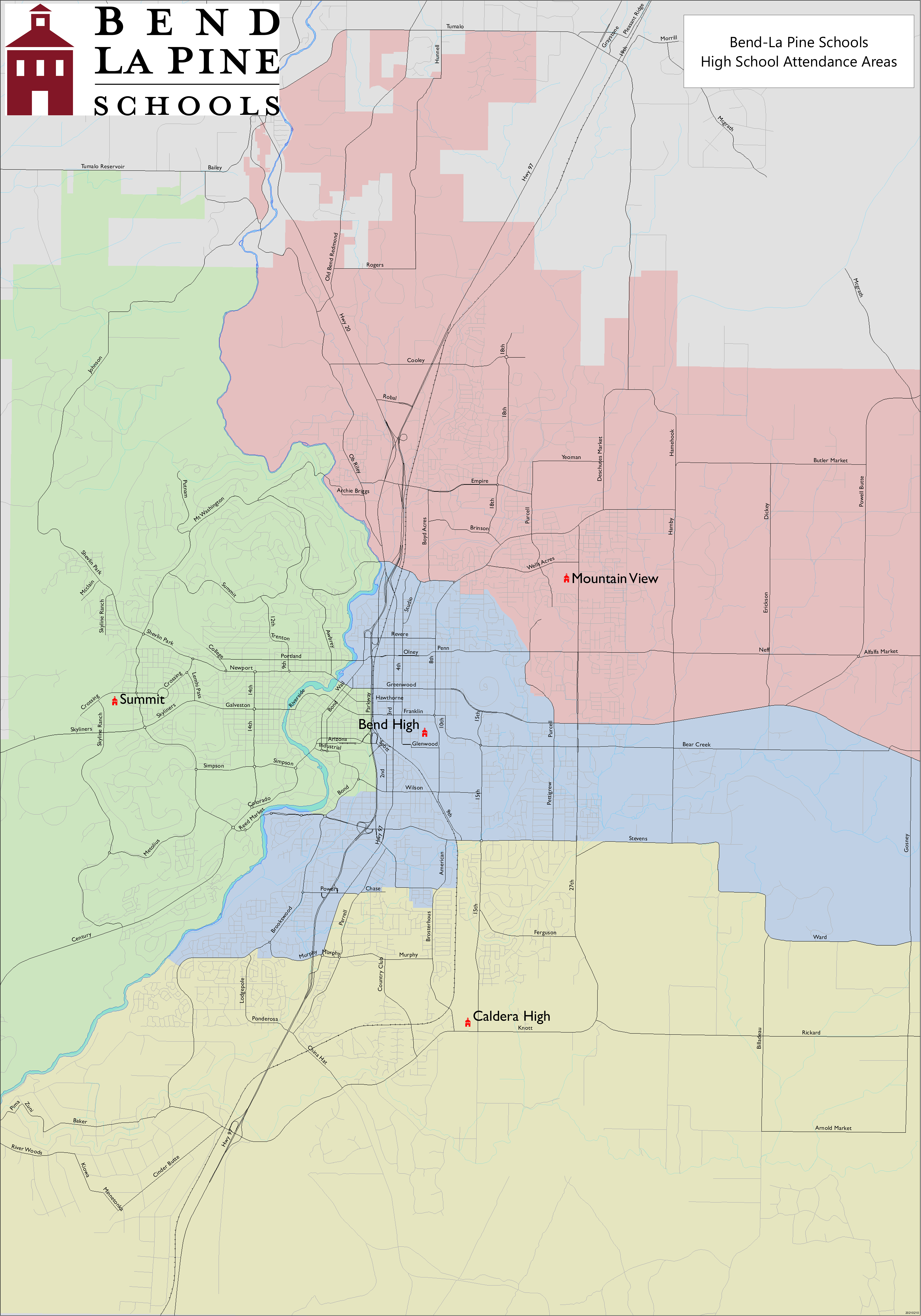
[edit]It is in the Bend-La Pine School District.[9] Zoned schools are:[10] W. E. Miller Elementary School,[11] Cascade Middle School,[12] and Summit High School.[13]
Deschutes County is in the boundary of Central Oregon Community College.[14]
References
[edit]- ^ "ArcGIS REST Services Directory". United States Census Bureau. Retrieved October 12, 2022.
- ^ a b "Census Population API". United States Census Bureau. Retrieved October 12, 2022.
- ^ "Seventh Mountain OR ZIP Code". zipdatamaps.com. 2023. Retrieved June 16, 2023.
- ^ a b U.S. Geological Survey Geographic Names Information System: Seventh Mountain, Oregon
- ^ a b Oregon Atlas & Gazetteer (7th ed.). Yarmouth, Maine: DeLorme. 2008. pp. 43, 50. ISBN 978-0-89933-347-2.
- ^ Merriman, Ed (October 19, 2010). "Resort Sporting New Look". The Bend Bulletin. Retrieved December 16, 2014.
- ^ a b "Geographic Identifiers: 2010 Demographic Profile Data (G001): Seventh Mountain CDP, Oregon". U.S. Census Bureau, American Factfinder. Archived from the original on February 13, 2020. Retrieved December 14, 2015.
- ^ "Census of Population and Housing". Census.gov. Retrieved June 4, 2016.
- ^ Geography Division (December 18, 2020). 2020 CENSUS - SCHOOL DISTRICT REFERENCE MAP: Deschutes County, OR (PDF) (Map). U.S. Census Bureau. Retrieved April 3, 2025.
- ^ Geography Division (April 9, 2021). "2020 CENSUS - CENSUS BLOCK MAP: Seventh Mountain CDP, OR" (PDF). U.S. Census Bureau. Retrieved April 3, 2025.
- ^ "Elementary Attendance Areas". Bend-La Pine School District. Retrieved April 3, 2025.
- ^ "Middle School Attendance Areas". Bend-La Pine School District. Retrieved April 3, 2025.
- ^ "High School Attendance Areas". Bend-La Pine School District. Retrieved April 3, 2025.
- ^ "Oregon Community Colleges and Community College Districts" (PDF). Oregon Department of Community Colleges & Workforce Development. Retrieved April 3, 2025.
Municipalities and communities of Deschutes County, Oregon, United States | ||
|---|---|---|
| Cities |  | |
| CDPs | ||
| Other communities | ||
| Footnotes | ‡This populated place also has portions in an adjacent county or counties | |
This Deschutes County, Oregon state location article is a stub. You can help Wikipedia by expanding it. |