
Quay Street, Auckland
 Quay Street looking east, 2011 | |
 | |
| Length | 1.8 km (1.1 mi) |
|---|---|
| Location | Auckland CBD, New Zealand |
| Postal code | 1010 |
| West end | Hobson Street, Viaduct Harbour |
| East end | Tamaki Drive, The Strand |
Quay Street is the northernmost street in the Auckland CBD, New Zealand. The Auckland Ferry Terminal, which has ferries running to Devonport, Waiheke Island, and other places in Waitematā Harbour; the Hilton Auckland hotel; and Ports of Auckland are on the north side of the street. The Britomart Transport Centre, Queen Elizabeth Square and Grand Mercure Auckland hotel are on the south side.
Demographics
[edit]The Quay Street-Customs Street statistical area covers 1.22 km2 (0.47 sq mi)[1] and had an estimated population of 2,060 as of June 2024,[2] with a population density of 1,689 people per km2.
| Year | Pop. | ±% p.a. |
|---|---|---|
| 2006 | 1,104 | — |
| 2013 | 2,256 | +10.75% |
| 2018 | 2,274 | +0.16% |
| 2023 | 1,962 | −2.91% |
| Source: [3][4] | ||
Quay Street-Customs Street had a population of 1,962 in the 2023 New Zealand census, a decrease of 312 people (−13.7%) since the 2018 census, and a decrease of 294 people (−13.0%) since the 2013 census. There were 1,098 males, 858 females and 9 people of other genders in 1,065 dwellings.[5] 8.4% of people identified as LGBTIQ+. The median age was 34.5 years (compared with 38.1 years nationally). There were 132 people (6.7%) aged under 15 years, 564 (28.7%) aged 15 to 29, 1,080 (55.0%) aged 30 to 64, and 186 (9.5%) aged 65 or older.[4]
People could identify as more than one ethnicity. The results were 40.5% European (Pākehā); 8.3% Māori; 5.8% Pasifika; 48.3% Asian; 6.7% Middle Eastern, Latin American and African New Zealanders (MELAA); and 1.5% other, which includes people giving their ethnicity as "New Zealander". English was spoken by 94.0%, Māori language by 2.0%, Samoan by 0.8%, and other languages by 42.0%. No language could be spoken by 1.4% (e.g. too young to talk). New Zealand Sign Language was known by 0.3%. The percentage of people born overseas was 65.0, compared with 28.8% nationally.
Religious affiliations were 28.1% Christian, 6.9% Hindu, 4.4% Islam, 0.6% Māori religious beliefs, 2.9% Buddhist, 0.9% New Age, 0.2% Jewish, and 1.8% other religions. People who answered that they had no religion were 49.2%, and 5.4% of people did not answer the census question.
Of those at least 15 years old, 819 (44.8%) people had a bachelor's or higher degree, 612 (33.4%) had a post-high school certificate or diploma, and 402 (22.0%) people exclusively held high school qualifications. The median income was $47,100, compared with $41,500 nationally. 297 people (16.2%) earned over $100,000 compared to 12.1% nationally. The employment status of those at least 15 was that 1,089 (59.5%) people were employed full-time, 180 (9.8%) were part-time, and 93 (5.1%) were unemployed.[4]
History
[edit]The street was proposed in 1878[6] on reclaimed land[7] and was in existence by the end of 1879.[8] It was extended to the east to Campbell's Point (Judges Bay) in 1916.[9]
Double railway tracks were in use down Quay Street connecting the Auckland Railway Station to the wharves until most were removed in 1985, and the final piece in 1989.[10]
Notable locations
[edit]
- Harbour Historic Area, north side of Quay Street, 1904-1924, wharves and associated buildings.[11]
- Launchman's Building, Quay Street West, 1930s, now New Zealand Maritime Museum.[12]
- First World War Memorial Beacon, Princes Wharf, 1915, earliest built monument for World War I in New Zealand.[13]
- Princes Wharf, 1929, cruise ship terminal and Hilton Hotel.
- Wharf Pavilions, 1915, relocated 1923, two buildings, currently a booking office for Fullers Group.[14]
- Ferry Building, 99 Quay Street, 1912, focus for Waitematā Harbour ferry traffic.[15]
- Queens Wharf, 1907-1913, significant part of Auckland's economy.[16]
- Queens Wharf Gates, north side of Quay Street on Queens Wharf, iconic red gates and fence.[17]
- Quay Street Historic Area, south side of Quay Street East, 1874-1907, industrial buildings, offices and warehouses.[18]
- Wharf Police building, 102 Quay Street, 1903, Chelsea Sugar Refining Company headquarters 1903-1960.[19]
- Union Fish Company building, 116-118 Quay Street, 1906, car importing and engineering workshop 1906-1970s.[20]
- Northern Steamship Company building, 122-124 Quay Street, 1898, Northern Steamship Company offices 1898-1974.[21]
- Auckland Harbour Board Workshops, 204 Quay Street, 1944-1989, site spread between Lower Hobson St, Customs Street and Quay Street, repair of boats, cranes and other equipment.[22]
- Port of Auckland, container and trade port on the north side of Quay Street.
- Auckland City Arena, south side, 2007, sports and entertainment centre.
Image gallery
[edit]-
 Wharf Pavilions and Ferry Building on Quay Street in 2023
 -
 Former Wharf Police Building on Quay Street
 -
 Northern Steamship Company and Union Fish Company Buildings
 -
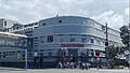
 Endeans Building
 -
 Former Auckland Harbour Board Workshops
 -

-
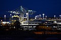 Port of Auckland
.jpg)
.jpg)
.jpg)
.jpg)
.jpg)
.jpg)
.jpg)
References
[edit]- ^ "Stats NZ Geographic Data Service". Statistical Area 2 2023 (generalised). Retrieved 8 January 2025.
- ^ "Aotearoa Data Explorer". Statistics New Zealand. Retrieved 26 October 2024.
- ^ "Statistical area 1 dataset for 2018 Census". Statistics New Zealand. March 2020. Quay Street-Customs Street (133300). 2018 Census place summary: Quay Street-Customs Street
- ^ a b c "Totals by topic for individuals, (RC, TALB, UR, SA3, SA2, Ward, Health), 2013, 2018, and 2023 Censuses". Stats NZ – Tatauranga Aotearoa – Aotearoa Data Explorer. Quay Street-Customs Street (133301). Retrieved 3 October 2024.
- ^ "Totals by topic for dwellings, (RC, TALB, UR, SA3, SA2, Ward, Health), 2013, 2018, and 2023 Censuses". Stats NZ – Tatauranga Aotearoa – Aotearoa Data Explorer. Retrieved 3 October 2024.
- ^ "General Assembly". New Zealand Herald. 29 July 1878. p. 3.
- ^ "Untitled". Auckland Star. 21 November 1878. p. 2.
- ^ "New Buildings at Queen-Street Wharf". New Zealand Herald. 6 December 1879. p. 6.
- ^ "Local and General News". New Zealand Herald. 22 April 1916. p. 6.
- ^ Bush, Graham W. A. (1991). Advance in Order: The Auckland City Council from Centenary to Reorganisation 1971-1989. Auckland City Council. pp. 80–82. ISBN 0-908834-03-9.
- ^ "Harbour Historic Area". New Zealand Heritage List/Rārangi Kōrero. Heritage New Zealand. Retrieved 22 July 2020.
- ^ "Launch Offices". New Zealand Heritage List/Rārangi Kōrero. Heritage New Zealand. Retrieved 22 July 2020.
- ^ "First World War Memorial Beacon". New Zealand Heritage List/Rārangi Kōrero. Heritage New Zealand. Retrieved 22 July 2020.
- ^ "Wharf Pavilions (Two Buildings)". New Zealand Heritage List/Rārangi Kōrero. Heritage New Zealand. Retrieved 22 July 2020.
- ^ "Ferry Building". New Zealand Heritage List/Rārangi Kōrero. Heritage New Zealand. Retrieved 22 July 2020.
- ^ "Queens Wharf". New Zealand Heritage List/Rārangi Kōrero. Heritage New Zealand. Retrieved 22 July 2020.
- ^ "Queens Wharf Gates". New Zealand Heritage List/Rārangi Kōrero. Heritage New Zealand. Retrieved 22 July 2020.
- ^ "Quay Street Historic Area". New Zealand Heritage List/Rārangi Kōrero. Heritage New Zealand. Retrieved 22 July 2020.
- ^ "Wharf Police Building". New Zealand Heritage List/Rārangi Kōrero. Heritage New Zealand. Retrieved 22 July 2020.
- ^ "Union Fish Company Building". New Zealand Heritage List/Rārangi Kōrero. Heritage New Zealand. Retrieved 22 July 2020.
- ^ "Northern Steamship Company Building". New Zealand Heritage List/Rārangi Kōrero. Heritage New Zealand. Retrieved 22 July 2020.
- ^ "Auckland Harbour Board Workshops". New Zealand Heritage List/Rārangi Kōrero. Heritage New Zealand. Retrieved 22 July 2020.
36°50′38″S 174°46′16″E / 36.844°S 174.771°E
External links
[edit]![]() Media related to Quay Street, Auckland at Wikimedia Commons
Media related to Quay Street, Auckland at Wikimedia Commons