Minamifurano, Hokkaido
Appearance
(Redirected from Minamifurano, Hokkaidō)
This article needs additional citations for verification. (October 2022) |
You can help expand this article with text translated from the corresponding article in Japanese. (June 2022) Click [show] for important translation instructions.
|
Minamifurano
南富良野町 | |
|---|---|
Town | |
 Minami Furano town hall | |
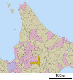
 Location of Minamifurano in Hokkaido (Kamikawa Subprefecture) | |
| Coordinates: 43°10′N 142°34′E / 43.167°N 142.567°E | |
| Country | Japan |
| Region | Hokkaido |
| Prefecture | Hokkaido (Kamikawa Subprefecture) |
| District | Sorachi |
| Area | |
• Total | 665.52 km2 (256.96 sq mi) |
| Population (September 30, 2016) | |
• Total | 2,611 |
| • Density | 3.9/km2 (10/sq mi) |
| Time zone | UTC+09:00 (JST) |
| Website | town |
Minamifurano (南富良野町, Minamifurano-chō) is a town located in Kamikawa Subprefecture, Hokkaido, Japan.
As of September 2016, the town has an estimated population of 2,611 and a density of 3.9 persons per km2. The total area is 665.52 km2.
Culture
[edit]Mascot
[edit]
Minamifurano's mascot is Minami-chan (南ちゃん). She is a girl who wears a helmet resembling a curling rock and her clothes and hairclips resembles carrots and her bag resembles corn. She was unveiled in 2018.[1]
Transportation
[edit]Highway
[edit]Sister cities
[edit]![]() Motobu, Japan, 1996
Motobu, Japan, 1996
Climate
[edit]| Climate data for Minmifurano (Ikutora), elevation 350 m (1,150 ft), (1991–2020 normals, extremes 1977–present) | |||||||||||||
|---|---|---|---|---|---|---|---|---|---|---|---|---|---|
| Month | Jan | Feb | Mar | Apr | May | Jun | Jul | Aug | Sep | Oct | Nov | Dec | Year |
| Record high °C (°F) | 7.2 (45.0) |
12.6 (54.7) |
15.3 (59.5) |
26.2 (79.2) |
32.6 (90.7) |
33.5 (92.3) |
34.0 (93.2) |
34.9 (94.8) |
32.1 (89.8) |
26.3 (79.3) |
19.1 (66.4) |
12.1 (53.8) |
34.9 (94.8) |
| Mean daily maximum °C (°F) | −3.7 (25.3) |
−2.6 (27.3) |
1.7 (35.1) |
8.9 (48.0) |
16.4 (61.5) |
20.7 (69.3) |
24.1 (75.4) |
24.3 (75.7) |
20.2 (68.4) |
13.6 (56.5) |
5.6 (42.1) |
−1.3 (29.7) |
10.7 (51.2) |
| Daily mean °C (°F) | −8.4 (16.9) |
−7.6 (18.3) |
−2.8 (27.0) |
3.8 (38.8) |
10.4 (50.7) |
14.9 (58.8) |
18.8 (65.8) |
19.2 (66.6) |
14.8 (58.6) |
8.0 (46.4) |
1.5 (34.7) |
−5.2 (22.6) |
5.6 (42.1) |
| Mean daily minimum °C (°F) | −14.6 (5.7) |
−14.4 (6.1) |
−8.6 (16.5) |
−1.6 (29.1) |
4.2 (39.6) |
9.6 (49.3) |
14.4 (57.9) |
14.9 (58.8) |
9.9 (49.8) |
2.7 (36.9) |
−2.8 (27.0) |
−10.3 (13.5) |
0.3 (32.5) |
| Record low °C (°F) | −32.2 (−26.0) |
−33.4 (−28.1) |
−31.2 (−24.2) |
−18.5 (−1.3) |
−4.6 (23.7) |
−1.1 (30.0) |
3.2 (37.8) |
3.4 (38.1) |
−2.0 (28.4) |
−7.5 (18.5) |
−20.0 (−4.0) |
−28.2 (−18.8) |
−33.4 (−28.1) |
| Average precipitation mm (inches) | 38.4 (1.51) |
32.8 (1.29) |
54.2 (2.13) |
72.4 (2.85) |
82.8 (3.26) |
71.0 (2.80) |
119.3 (4.70) |
187.0 (7.36) |
153.3 (6.04) |
112.2 (4.42) |
100.8 (3.97) |
66.5 (2.62) |
1,090.7 (42.95) |
| Average snowfall cm (inches) | 130 (51) |
111 (44) |
115 (45) |
37 (15) |
0 (0) |
0 (0) |
0 (0) |
0 (0) |
0 (0) |
4 (1.6) |
58 (23) |
147 (58) |
601 (237) |
| Average extreme snow depth cm (inches) | 66 (26) |
75 (30) |
77 (30) |
37 (15) |
0 (0) |
0 (0) |
0 (0) |
0 (0) |
0 (0) |
2 (0.8) |
17 (6.7) |
46 (18) |
84 (33) |
| Average precipitation days (≥ 1.0 mm) | 11.4 | 10.4 | 12.5 | 12.7 | 11.3 | 9.3 | 11.2 | 11.6 | 12.6 | 13.4 | 15.0 | 14.4 | 145.8 |
| Average snowy days (≥ 3.0 cm) | 16.6 | 15.3 | 14.4 | 5.1 | 0.1 | 0 | 0 | 0 | 0 | 0.3 | 6.4 | 17.7 | 75.9 |
| Mean monthly sunshine hours | 88.5 | 95.2 | 123.1 | 153.8 | 176.1 | 162.3 | 153.2 | 146.9 | 139.0 | 131.5 | 82.4 | 67.1 | 1,519.1 |
| Source 1: Japan Meteorological Agency[2] | |||||||||||||
| Source 2: Japan Meteorological Agency[3] | |||||||||||||
References
[edit]- ^ "南富良野町の下水道の歴史" (PDF). Minamifurano.
- ^ 観測史上1~10位の値(年間を通じての値). JMA. Retrieved 21 July 2025.
- ^ 気象庁 / 平年値(年・月ごとの値). JMA. Retrieved 21 July 2025.
External links
[edit] Media related to Minamifurano, Hokkaidō at Wikimedia Commons
- Official Website (in Japanese)


