From Wikipedia, the free encyclopedia
District in Hokkaido, Japan
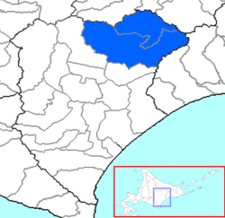 The area of Ashoro District in Tokachi Subprefecture.
Ashoro (足寄郡, Ashoro-gun) is a district located in Tokachi Subprefecture, Hokkaido, Japan.[1][2]
As of 2004, the district has an estimated population of 11,424 and a density of 5.66 persons per km2. The total area is 2,016.90 km2.
- 1869 Provinces and districts established in Hokkaido, Ashoro District created in Kushiro Province
- October 20, 1948 Ashoro District split off from Kushirokuni Subprefecture (now Kushiro Subprefecture) and incorporated into Tokachi Subprefecture
- April 1, 1951 Part of Nishiashoro town, Nakagawa District incorporated into Rikubetsu town
- April 1, 1955 Nishiashoro town, (from Nakagawa District) merged with Ashoro village to elevate Ashoro town, (from Ashoro District)
- ^ "町の情報" [Town Information]. ASHORO-TOWN (in Japanese). 2021-11-22. Retrieved 2025-06-07.
- ^ "北海道 ホッカイドウ > 足寄郡足寄町" [Postal Code Search Hokkaido Hokkaido > Ashoro Town, Ashoro District]. JAPAN POST (in Japanese). Retrieved 2025-06-07.
43°24′56″N 143°37′06″E / 43.41556°N 143.61833°E / 43.41556; 143.61833


