Machchangolhi
Appearance
Machchangolhi
މައްޗަންގޮޅީ | |
|---|---|
District of Malé | |
 | |
| Country | Maldives |
| Government | |
| • Council | Malé City Council |
| Population (2022)[1] | |
• Total | 27,706 |
| Time zone | UTC+05:00 (MVT) |
Machchangolhi (Dhivehi: މައްޗަންގޮޅީ), also known as Machangolhi, is a district of Malé, Maldives.[2][3]
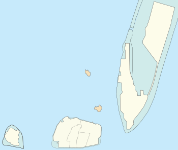
Location within Malé City
[edit]Machchangolhi is in the southern and central portions of Malé Island:

Hen.
Gal.
Mac.
Maa.
← Gulhi Falhu
Dho.
Fun.
Gal. = 1 Galolhu
Hen. = 2 Henveiru
Maa. = 3 Maafannu
Mac. = 4 Machchangolhi
not part of Malé City:
Dho. = Dhoonidhoo (Prison Island)
Fun. = Funadhoo
References
[edit]- ^ "Table P5: Resident Population by island and sex, 2022" (PDF). census.gov.mv. Retrieved 29 March 2025.
- ^ "Local regulations in the Maldives". CivEng. Retrieved 30 January 2019.
- ^ Cros, Patrick (2008). Maldives. p. 71. ISBN 9782713102677.
4°10′26″N 73°30′29″E / 4.174°N 73.508°E
