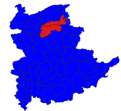
Lashio District
Appearance
Lashio
လားရှိုးခရိုင် | |
|---|---|
 Location in Shan State | |
| Coordinates: 22°55′00″N 97°44′00″E / 22.91667°N 97.73333°E | |
| Country | |
| State | |
| Capital | Lashio |
| Elevation | 864 m (2,835 ft) |
| Time zone | UTC+6.30 (MST) |
Lashio District (Burmese: လားရှိုးခရိုင်) is a district of northern Shan State in Myanmar with three townships. Its capital is the north Shan State capital of Lashio.
Townships
[edit]
Hseni
Kunlong
Lashio
The district contains three township:
- Lashio Township
- Hsenwi Township
- Kunlong Township (formerly part of Kunlong District)
In 2022, the Ministry of Home Affairs split off two townships (Tangyan Township and Mongyai Township) to form the new Tangyyan District .[2][3]
Prior to 2011, Lashio District also included the following townships, which became now part of Hopang District. Therefore, they are no longer part of Lashio District since September 2011.[4]
- Mongmao Township
- Namphan Township also spelled as Naphan Township
- Pangsang Township also spelled as Panhkam Township
- Pangwaun Township also spelled as Panwai Township
It consisted of four towns and 2431 villages in 2001.
References
[edit]- ^ GoogleEarth
- ^ "Expansion of new districts: New districts expanded in Nay Pyi Taw, regions and states". Myanmar International Television. 2 May 2022.
- ^ "Expansion of new districts in Nay Pyi Taw, regions and states". 2 May 2022.
- ^ Page 10 Column 3[permanent dead link]


