
La Nova Esquerra de l'Eixample
This article needs additional citations for verification. (March 2021) |
La Nova Esquerra de l'Eixample | |
|---|---|
 | |
| Country | |
| Autonomous community | Catalonia |
| Province | Barcelona |
| Comarca | Barcelonès |
| Municipality | Barcelona |
| District | Eixample |
| Area | |
• Total | 1.338 km2 (0.517 sq mi) |
| Population | |
• Total | 57,676 |
| • Density | 43,000/km2 (110,000/sq mi) |
La Nova Esquerra de l'Eixample (Catalan for Expansion, New Left, meaning the newer sector of L'Eixample ['the Expansion'] on the west/left side of Carrer de Balmes) is a neighborhood in the Eixample district of Barcelona, Catalonia (Spain). Originally it formed a single unit, called Esquerra de l'Eixample, with the current neighborhood l'Antiga Esquerra de l'Eixample.
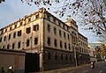
In this neighborhood there are the Can Batlló's three buildings (currently the Industrial School), the former prison La Model, the park Parc de Joan Miró, located in the emplacement of the former city's slaughterhouse, the bullfighting ring Las Arenas, which is nowadays a shopping centre, and the Casa Golferichs.
Due to its considerable Romanian migrant population, La Nova Esquerra de l'Eixample has been defined as a "Little Romania".[2][3]
-
 Sculpture Dona i Ocell at the Parc de Joan Miró
 -
 Les Arenes During its remodelation (2010)
 -
-


References
[edit]- ^ a b "La Nova Esquerra de l'Eixample - L'Eixample - Ajuntament de Barcelona" (in Catalan). Ajuntament de Barcelona. Retrieved 2025-04-23.
- ^ Gorman, David (21 March 2021). "Un 'Little Romania' surge en El Eixample: tiendas especializadas y restaurantes típicos". Metrópoli Abierta (in Spanish).
- ^ Paun, Meritxell M. (3 March 2014). "Un 'Little Romania' florece en el Eixample izquierdo". La Vanguardia (in Spanish).
External links
[edit]- Web of La Nova Esquerra de l'Eixample, Barcelona's City Hall Web (Catalan)
41°23′0.2″N 2°8′56.4″E / 41.383389°N 2.149000°E
This Province of Barcelona location article is a stub. You can help Wikipedia by expanding it. |