Johnston Square, Baltimore
Appearance
This article includes a list of general references, but it lacks sufficient corresponding inline citations. (August 2025) |
Johnston Square | |
|---|---|
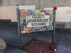
 Johnston Square gateway sign at the corner of Greenmount Avenue and E. Biddle Street in Baltimore | |
| Country | |
| State | |
| City | |
| Time zone | UTC−5 (Eastern) |
| • Summer (DST) | UTC−4 (EDT) |
| Area Codes | 410, 443, 667 |
Johnston Square is a neighborhood in central Baltimore, Maryland located east of the Fallsway and west of the Oliver neighborhood, bordered by Greenmount Cemetery at the north and Eager Street at the south.
The neighborhood contains Johnston Square Elementary School, and two parks: Johnston Square Park and Ambrose Kennedy Park. It is one of five neighborhoods whose Urban Renewal Plans are included in the East Baltimore Revitalization Plan.[1] The neighborhood contains portions of the Baltimore City Correctional Facilities and its residents are mostly low income African-American families. It has been used as a filming location on the HBO drama The Wire.
References
[edit]- ^ "Archived copy" (PDF). Archived from the original (PDF) on December 21, 2013. Retrieved December 15, 2013.
{{cite web}}: CS1 maint: archived copy as title (link)
External links
[edit]- Johnston Square Profile at Live Baltimore
- Johnston Square Elementary School Archived 2016-03-03 at the Wayback Machine
- Johnston Square Urban Renewal Plan
39°18′11″N 76°36′20.5″W / 39.30306°N 76.605694°W
