
Jimtown, Oklahoma
Jimtown, Oklahoma | |
|---|---|
 Jimtown  Jimtown | |
| Coordinates: 33°51′43″N 97°22′10″W / 33.86194°N 97.36944°W | |
| Country | United States |
| State | Oklahoma |
| County | Love |
| Elevation | 761 ft (232 m) |
| Time zone | UTC-6 (Central (CST)) |
| • Summer (DST) | UTC-5 (CDT) |
| GNIS feature ID | 1100538[1] |
Jimtown is a small unincorporated community in Love County, Oklahoma, United States.[1] The settlement is old enough to appear on a 1911 Rand McNally map of the county.[2]
References
[edit]- ^ a b c U.S. Geological Survey Geographic Names Information System: Jimtown, Oklahoma
- ^ "Love County, Oklahoma 1911 Map". Rand McNally (accessed on MyGenealogyHound website). Retrieved March 7, 2025.
Municipalities and communities of Love County, Oklahoma, United States | ||
|---|---|---|
| City | 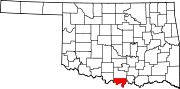 | |
| Towns | ||
| CDP | ||
| Other communities | ||
| Indian reservation | ||
| Footnotes | ‡This populated place also has portions in an adjacent county or counties | |
This Oklahoma state location article is a stub. You can help Wikipedia by expanding it. |