
File:Occupation borders in Slovenia 1941-1945. Border lines and occupied territories.tif

Size of this JPG preview of this TIF file: 800 × 565 pixels. Other resolutions: 320 × 226 pixels | 640 × 452 pixels | 1,024 × 723 pixels | 1,280 × 904 pixels | 2,560 × 1,808 pixels | 3,094 × 2,185 pixels.
Original file (3,094 × 2,185 pixels, file size: 19.34 MB, MIME type: image/tiff)
| This is a file from the Wikimedia Commons. Information from its description page there is shown below. Commons is a freely licensed media file repository. You can help. |
Summary
| Description |
English: historical map |
| Date | |
| Source |
The map is the result of work on the research project Make me this German-Italian-Hungarian-Croatian country! The role of occupation borders in denationalization policy and the life of the Slovenian population. (Funded by ARRS J6-8248). The project was implemented by Kornelija Ajlec, Bojan Balkovec, Rok Ciglič, Božidar Flajšman, Aleš Gabrič, Primož Gašperič, Bojan Godeša, Darja Kerec, Attila Kovacs, Peter Mikša, Božo Repe (manager), Maja Vehar, Manca Volk Bahun, Matija Zorn. Authors allow publication. https://okupacijskemeje.si/exh01-ch02.html |
| Author | Manca Volk Bahun, Rok Ciglič, Matija Zorn |
| Permission (Reusing this file) |
|
| Other versions |
|

Licensing
This file is licensed under the Creative Commons Attribution-Share Alike 4.0 International license.
- You are free:
- to share – to copy, distribute and transmit the work
- to remix – to adapt the work
- Under the following conditions:
- attribution – You must give appropriate credit, provide a link to the license, and indicate if changes were made. You may do so in any reasonable manner, but not in any way that suggests the licensor endorses you or your use.
- share alike – If you remix, transform, or build upon the material, you must distribute your contributions under the same or compatible license as the original.
File history
Click on a date/time to view the file as it appeared at that time.
| Date/Time | Thumbnail | Dimensions | User | Comment | |
|---|---|---|---|---|---|
| current | 10:07, 29 May 2023 | 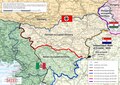 | 3,094 × 2,185 (19.34 MB) | Bb63lj | Uploaded a work by Manca Volk Bahun, Rok Ciglič, Matija Zorn from The map is the result of work on the research project Make me this German-Italian-Hungarian-Croatian country! The role of occupation borders in denationalization policy and the life of the Slovenian population. (Funded by ARRS J6-8248). The project was implemented by Kornelija Ajlec, Bojan Balkovec, Rok Ciglič, Božidar Flajšman, Aleš Gabrič, Primož Gašperič, Bojan Godeša, Darja Kerec, Attila Kovacs, Peter Mikša, Božo Repe (mana... |
File usage
The following page uses this file:
Global file usage
The following other wikis use this file:
- Usage on bs.wikipedia.org
- Usage on fa.wikipedia.org
- Usage on fr.wikipedia.org
- Usage on mk.wikipedia.org