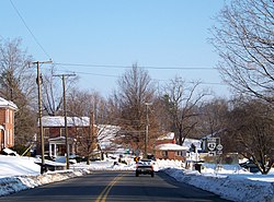
Churchville, Virginia
Appearance
Churchville | |
|---|---|
 | |
| Coordinates: 38°13′34″N 79°09′44″W / 38.22611°N 79.16222°W | |
| Country | United States |
| State | Virginia |
| County | Augusta |
| Elevation | 1,424 ft (434 m) |
| Population (2010) | |
• Total | 194 |
| Time zone | UTC−5 (EST) |
| • Summer (DST) | UTC−4 (EDT) |
| GNIS feature ID | 1492769[1] |
Churchville is a census-designated place (CDP) in western Augusta County, Virginia, United States. It was first listed as a CDP in the 2010 United States Census, at which time it had a population of 194.[2][3]
An 1855 gazetteer described the village as a stagecoach stop with "2 churches, 2 stores, and 2 schools."[4]
Hanger Mill was listed on the National Register of Historic Places in 1991.[5]
Demographics
[edit]| Census | Pop. | Note | %± |
|---|---|---|---|
| U.S. Decennial Census[6] [7] | |||
References
[edit]- ^ "Churchville". Geographic Names Information System. United States Geological Survey, United States Department of the Interior.
- ^ "U.S. Census website". United States Census Bureau. Retrieved May 14, 2011.
- ^ "Virginia Trend Report 2: State and Complete Places (Sub-state 2010 Census Data)". Missouri Census Data Center. Archived from the original on July 11, 2012. Retrieved June 8, 2011.
- ^ Edwards, Richard (1855). Statistical Gazetteer of the State of Virginia. Richmond, Virginia: Richard Edwards. p. 209.
- ^ "National Register Information System". National Register of Historic Places. National Park Service. July 9, 2010.
- ^ "Decennial Census by Decade". United States Census Bureau.
- ^ "2010 Census of Population - Population and Housing Unit Counts - Virginia" (PDF). United States Census Bureau.


