Buckeye, West Virginia
Appearance
Buckeye, West Virginia | |
|---|---|
| Coordinates: 38°11′09″N 80°08′04″W / 38.18583°N 80.13444°W | |
| Country | United States |
| State | West Virginia |
| County | Pocahontas |
| Elevation | 2,110 ft (640 m) |
| Time zone | UTC-5 (Eastern (EST)) |
| • Summer (DST) | UTC-4 (EDT) |
| ZIP code | 24924 |
| Area code(s) | 304 & 681 |
| GNIS feature ID | 1554019[1] |
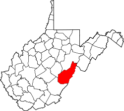
Buckeye is an unincorporated community in Pocahontas County, West Virginia, United States. Buckeye is located along U.S. Route 219, 3.5 miles (5.6 km) southwest of Marlinton.
The community takes its name from nearby Buckeye Cove.[2]
Climate
[edit]The climate in this area has mild differences between highs and lows, and there is adequate rainfall year-round. According to the Köppen system, Buckeye has a marine west coast climate, abbreviated Cfb on climate maps.[3] Buckeye holds the October record low of 3 °F or −16.1 °C for the state of West Virginia, recorded in 1962.
Notable people
[edit]References
[edit]- ^ "US Board on Geographic Names". United States Geological Survey. October 25, 2007. Retrieved January 31, 2008.
- ^ Kenny, Hamill. West Virginia Place Names: Their Origin and Meaning, Including the Nomenclature of the Streams and Mountains. Piedmont, WV. p. 134.
- ^ "Climate Summary for Buckeye, West Virginia". Weatherbase.


