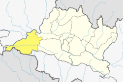
Bairiya
Appearance
Bairiya
बैरिया | |
|---|---|
Village | |
| Coordinates: 27°34′34″N 84°31′54″E / 27.576178°N 84.531785°E | |
| Country | |
| Zone | Narayani Zone |
| District | Chitwan District |
| Province | Bagmati |
| Government | |
| • Type | Municipality |
| • Ward President | Kul Prasad Bhushal |
| Population (1991)Increased | |
• Total | 2,936 |
| • Density | 1,200/km2 (3,000/sq mi) |
| Time zone | UTC+5:45 (Nepal Time) |
| Area code | 056 |
Bairiya is a village which comes under Rautahat District, ward no. 9, in Chitwan in the Narayani Zone of central Nepal. At the time of the 1991 Nepal census, it had a population of 2936 people living in 527 individual households. But it has increased due to more illiteracy. Most of the people are working towards improving their literacy and major development is going on. The literacy rate has been also reduced.[1]
Education
[edit]Schools
[edit]- Bairiya High School*
Madrasa Girls University
Tourism
[edit]Bairiya is a neighbour of Akolwa and is close to Rajpur Farhadwa
Tourism place
- Lal Bakaiya Bridge
- Baandh
Gallery
[edit]-
Sunset
Sports
[edit]Loads of Cricket Enthusiast
Sports Club
[edit]Some past event
[edit]- Bairiya Premier League
Notable people
[edit]- Rupak Sapkota, Software Developer & Tech Community Builder
- Surendra Pandey, Vice Chairman of CPN(UML)
- Azam Shaikh
References
[edit]- ^ "Nepal Census 2001". Nepal's Village Development Committees. Digital Himalaya. Archived from the original on 12 October 2008. Retrieved 25 November 2008.


