
Škrljevo
Škrljevo | |
|---|---|
Village | |
 | |
 | |
| Country | |
| County | Primorje-Gorski Kotar County |
| Area | |
• Total | 5.8 sq mi (15.0 km2) |
| Population (2021)[2] | |
• Total | 1,158 |
| • Density | 200/sq mi (77/km2) |
| Time zone | UTC+1 (CET) |
| • Summer (DST) | UTC+2 (CEST) |
Škrljevo is a village in Primorje, Croatia, located north of Bakar. The population is 1,344 (census 2011).[3] Škrljevo was mentioned by name for the first time during the reign of Petar Zrinski, in a document from 1667. Near the railway station are the remains of the church of St. Ambroza, demolished in 1907. [4]
History
[edit]At 10:20 on 30 June 2019, the fire department JVP Rijeka received a call about a fire along the Škrljevo-Meja section of the railway. The fire had been started by sparks from a train, and spread over a large area despite the efforts of the JVP Rijeka under commander Hinko Mance combined with aid from volunteer fire departments of Škrljevo, Sušak, Drenova, Zlobin, Bakar, Kostrena and Čavle. At 12:34, two HV Canadairs had to be called in, arriving at 13:32. The fire was localised by 14:30, but 15 hectares (37 acres) burned.[5]
Gallery
[edit]-
 Presveto Srce Isusovo church
 -
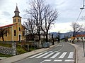 Main street
 -
 Train station

_in_%C5%A0krljevo_-_panoramio.jpg)

References
[edit]- ^ Register of spatial units of the State Geodetic Administration of the Republic of Croatia. Wikidata Q119585703.
- ^ "Population by Age and Sex, by Settlements" (xlsx). Census of Population, Households and Dwellings in 2021. Zagreb: Croatian Bureau of Statistics. 2022.
- ^ "Population by Age and Sex, by Settlements, 2011 Census: City of Bakar". Census of Population, Households and Dwellings 2011. Zagreb: Croatian Bureau of Statistics. December 2012. Retrieved 2013-09-06.
- ^ Černeka, Fabijan. "Naša mjesta". www.tz-bakar.hr (in Croatian). Retrieved 2023-04-30.
- ^ n.s. (December 2019). "Iskrenje vlaka izazvalo veliki požar kod Škrljeva" [Train Sparks Caused a Large Fire by Škrljevo] (PDF). Nazovi 193 (in Croatian). Vol. 12, no. 24. p. 7. Archived from the original (PDF) on 2022-09-27.
45°20′N 14°31′E / 45.333°N 14.517°E
| International | |
|---|---|
| National | |
This Primorje-Gorski Kotar County geography article is a stub. You can help Wikipedia by expanding it. |