
File:World map of total confirmed COVID-19 deaths per million people by country.png
Size of this preview: 800 × 565 pixels. Other resolutions: 320 × 226 pixels | 640 × 452 pixels | 1,024 × 723 pixels | 1,280 × 904 pixels | 2,560 × 1,807 pixels | 3,400 × 2,400 pixels.
Original file (3,400 × 2,400 pixels, file size: 871 KB, MIME type: image/png)
| This is a file from the Wikimedia Commons. Information from its description page there is shown below. Commons is a freely licensed media file repository. You can help. |
| This file may be updated to reflect new information. If you wish to use a specific version of the file without it being overwritten, please upload the required version as a separate file. |
Summary
| Description |
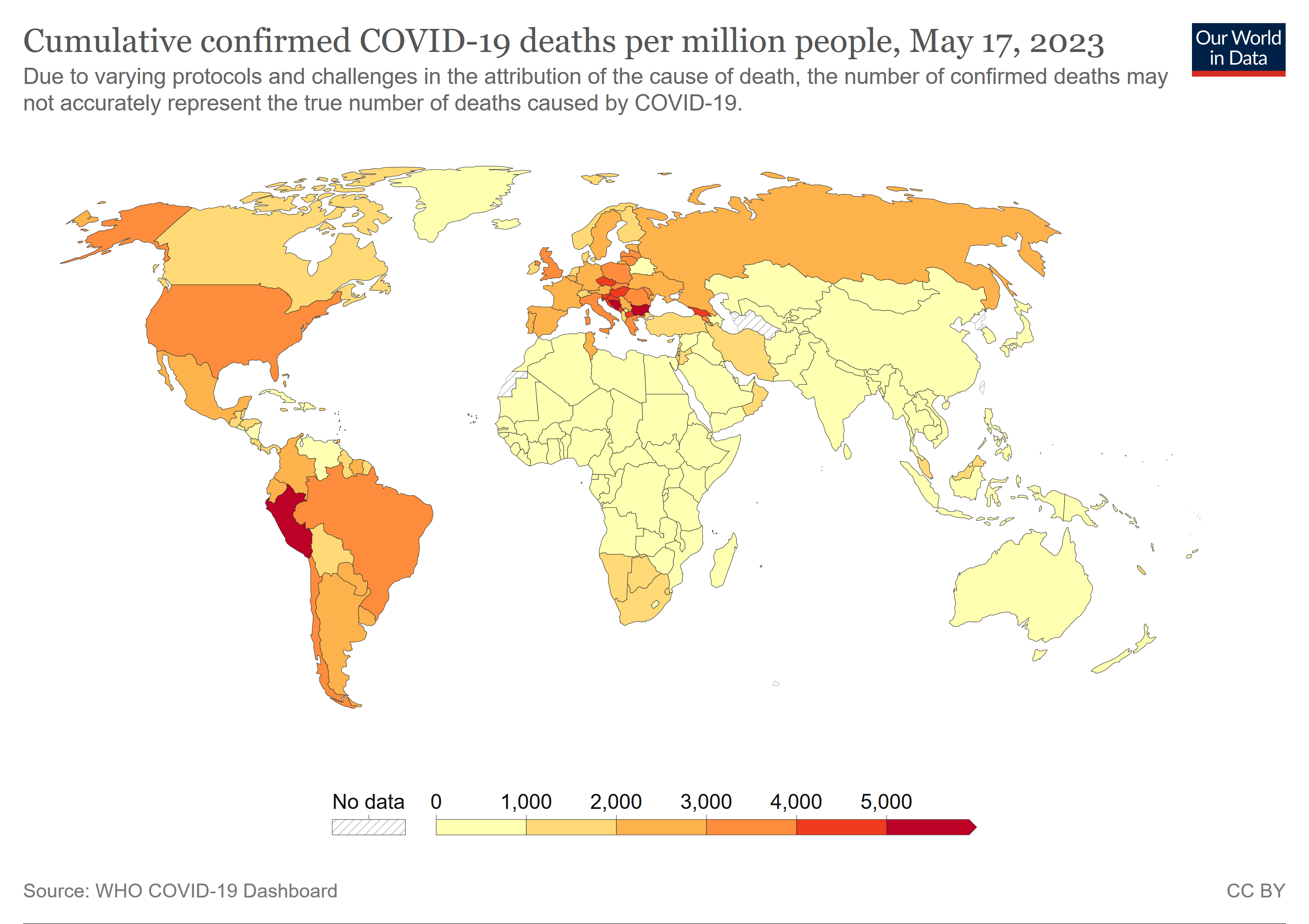
English: World map of total confirmed COVID-19 deaths per million people by country. |
| Date | is the date of the first upload to the Commons. See the file history below for the most recent upload date. Please upload new versions. Use the upload link at the end of the file history list. |
| Source | https://ourworldindata.org/grapher/total-covid-deaths-per-million - Click on the map tab. Then click the download tab, and the PNG link to get the PNG file. The table tab has a table of the exact data by country. For sources see the sources tab. Sources can change. The map at the source is interactive and provides more detail. For example, run your cursor over the color bar legend to see the countries that apply to that point in the legend. |
| Author | Our World In Data. See Wikipedia: Our World in Data. |
| Other versions | File:World map of total confirmed COVID-19 deaths per million people by country.svg |

|
File:World map of total confirmed COVID-19 deaths per million people by country.svg is a vector version of this file. It should be used in place of this PNG file when not inferior.
File:World map of total confirmed COVID-19 deaths per million people by country.png → File:World map of total confirmed COVID-19 deaths per million people by country.svg
For more information, see Help:SVG. |
 |
Licensing
This file is licensed under the Creative Commons Attribution 4.0 International license.
- You are free:
- to share – to copy, distribute and transmit the work
- to remix – to adapt the work
- Under the following conditions:
- attribution – You must give appropriate credit, provide a link to the license, and indicate if changes were made. You may do so in any reasonable manner, but not in any way that suggests the licensor endorses you or your use.
Any autoconfirmed user can overwrite this file from the same source. Please ensure that overwrites comply with the guideline.
File history
Click on a date/time to view the file as it appeared at that time.
| Date/Time | Thumbnail | Dimensions | User | Comment | |
|---|---|---|---|---|---|
| current | 02:26, 21 May 2023 | | 3,400 × 2,400 (871 KB) | Timeshifter | Latest |
| 05:27, 10 March 2023 |  | 3,400 × 2,400 (874 KB) | Timeshifter | Latest | |
| 01:36, 7 October 2022 |  | 3,400 × 2,400 (834 KB) | Timeshifter | Latest map from source. | |
| 20:55, 8 February 2022 |  | 3,400 × 2,400 (869 KB) | Timeshifter | Latest map from source. | |
| 23:19, 28 December 2021 |  | 3,400 × 2,400 (603 KB) | Timeshifter | Latest map from source. | |
| 21:36, 1 December 2021 |  | 3,400 × 2,400 (613 KB) | Timeshifter | Latest map from source. | |
| 20:20, 9 October 2021 |  | 3,400 × 2,400 (620 KB) | Timeshifter | Latest map from source. | |
| 13:03, 29 September 2021 |  | 3,400 × 2,400 (620 KB) | Timeshifter | Latest map from source. | |
| 20:11, 18 September 2021 |  | 3,400 × 2,400 (620 KB) | Timeshifter | Latest map from source. | |
| 03:02, 9 September 2021 |  | 3,400 × 2,400 (619 KB) | Timeshifter | Latest map from source. |
File usage
The following 6 pages use this file:
Global file usage
The following other wikis use this file:
- Usage on ar.wikipedia.org
- Usage on bn.wikipedia.org
- Usage on de.wikipedia.org
- Usage on eo.wikinews.org
- Usage on pt.wikipedia.org
- Usage on ru.wikipedia.org
- Usage on sat.wikipedia.org
- Usage on th.wikipedia.org
- Usage on zh.wikipedia.org