
File:Vardar003.png

Size of this preview: 503 × 600 pixels. Other resolutions: 201 × 240 pixels | 402 × 480 pixels | 717 × 855 pixels.
Original file (717 × 855 pixels, file size: 75 KB, MIME type: image/png)
| This is a file from the Wikimedia Commons. Information from its description page there is shown below. Commons is a freely licensed media file repository. You can help. |
Summary
| Description |
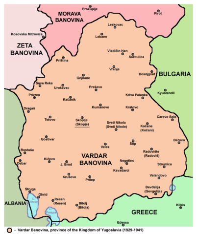
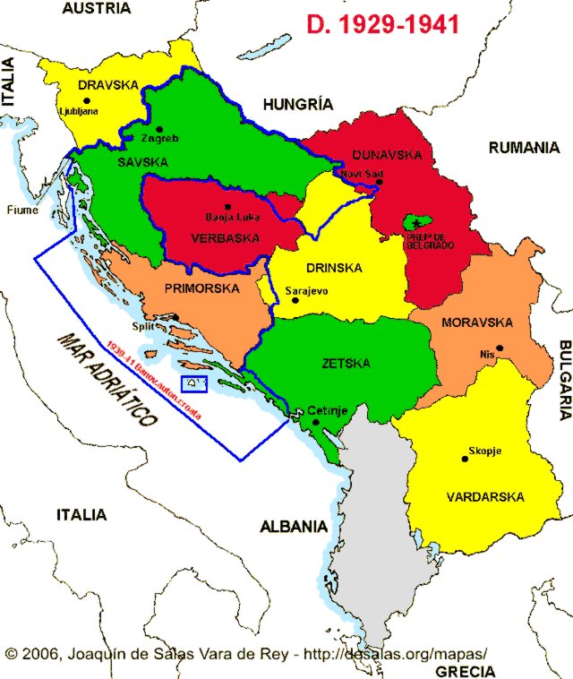
English: Map of the en:Vardar Banovina province of the Kingdom of Yugoslavia (1929-1941). Use with caution because Yugoslav internal borders are not differentiated from the international border. |
| Date | 11 September 2006 (original upload date) |
| Source | Transferred from en.wikipedia to Commons by BokicaK using CommonsHelper. |
| Author | Original uploader and author was PANONIAN at en.wikipedia |
Licensing
self made map by user:PANONIAN
| This work has been released into the public domain by its author, PANONIAN at English Wikipedia. This applies worldwide. In some countries this may not be legally possible; if so: PANONIAN grants anyone the right to use this work for any purpose, without any conditions, unless such conditions are required by law. |
References
- Istorijski atlas, Geokarta, Beograd, 1999.
- Školski istorijski atlas, Zavod za izdavanje udžbenika SR Srbije, Beograd, 1970.
- Denis Šehić - Demir Šehić, Istorijski atlas sveta, Beograd, 2007.
- Povijesni atlas, Učila - Zagreb, Zagreb, 1971.
- Istorijski atlas, Intersistem Kartografija, Beograd, 2010.
- Povijesni atlas za osnovnu školu, Kartografija - Tlos - Zagreb, Zagreb, 1975.
- The Times Atlas svjetske povijesti, Cankarjeva založba, Ljubljana - Zagreb, 1986.
- Dr Tomislav Bogavac, Nestajanje Srba, Niš, 1994.
- Džon R. Lempi, Jugoslavija kao istorija, Beograd, 2004.
- Petrit Imami, Srbi i Albanci kroz vekove, Beograd, 2000.
- Sve srpske mape - od šestog veka do Pariza, Specijalno izdanje BLICA, Decembar 1995
- http://i6.photobucket.com/albums/y226/mindaugas/Maps/banovina.gif (Note: image from Photobucket used only as a secondary reference)
- http://www.hrvatski-vojnik.hr/hrvatski-vojnik/0482005/bpictures/manovina%20Hrvatska.jpg
- http://i252.photobucket.com/albums/hh13/tomba17_photos/Geopoliticke%20zemljovide/KraljevinaJugoslavijaBanovine1929.jpg?t=1242016978 (Note: image from Photobucket used only as a secondary reference)
- http://anamnesis.info/resources/kraljevina_jugoslavija_podela_na_banovine.jpg
- http://www.hic.hr/dom/288/images/pod01.jpg archive copy at the Wayback Machine
- http://forum.net.hr/cfs-filesystemfile.ashx/__key/CommunityServer.Discussions.Components.Files/15/7041.Banovina-b.JPG archive copy at the Wayback Machine
- http://img101.imageshack.us/img101/5218/srezovibanovine.png
- http://bp0.blogger.com/_-JsoJVhpWFY/SH-2oWaqFAI/AAAAAAAAAs4/ElWGFsv5DCs/s1600-h/Vardaska_Banovina.jpg
- http://www.hkv.hr/images/stories/karte/Kraljevina_Jugoslavija_1929_karta.jpg
- http://www.stk-brovinje.hr/povijest/kviz_nacionalni_prvi_drugi/zupanijsko_2008_04_karta_01.jpg
- http://www.euratlas.net/history/hisatlas/balkan_states/194129YG.jpg
Original upload log
The original description page was here. All following user names refer to en.wikipedia.
- 2006-09-11 22:08 PANONIAN 467×546× (22015 bytes)
File history
Click on a date/time to view the file as it appeared at that time.
| Date/Time | Thumbnail | Dimensions | User | Comment | |
|---|---|---|---|---|---|
| current | 10:14, 4 October 2014 | | 717 × 855 (75 KB) | WikiEditor2004 | aesthetics |
| 08:38, 19 August 2011 |  | 718 × 855 (75 KB) | WikiEditor2004 | improved version | |
| 01:40, 17 September 2010 |  | 467 × 546 (21 KB) | File Upload Bot (Magnus Manske) | {{BotMoveToCommons|en.wikipedia|year={{subst:CURRENTYEAR}}|month={{subst:CURRENTMONTHNAME}}|day={{subst:CURRENTDAY}}}} {{Information |Description={{en|Map of the en:South Serbia (Juzna Serbia) (self made) [[:en:Category:Maps of the history of the |
File usage
The following 3 pages use this file:
Global file usage
The following other wikis use this file:
- Usage on af.wikipedia.org
- Usage on be-tarask.wikipedia.org
- Usage on be.wikipedia.org
- Usage on bg.wikipedia.org
- Usage on bn.wikipedia.org
- Usage on bs.wikipedia.org
- Usage on ca.wikipedia.org
- Usage on da.wikipedia.org
- Usage on de.wikipedia.org
- Usage on el.wikipedia.org
- Usage on es.wikipedia.org
- Usage on et.wikipedia.org
- Usage on fr.wikipedia.org
- Usage on he.wikipedia.org
- Usage on hr.wikipedia.org
- Usage on hy.wikipedia.org
- Usage on id.wikipedia.org
- Usage on it.wikipedia.org
- Usage on ja.wikipedia.org
- Usage on ka.wikipedia.org
- Usage on lt.wikipedia.org
- Usage on nl.wikipedia.org
- Usage on pt.wikipedia.org
- Usage on ro.wikipedia.org
- Usage on ru.wikipedia.org
- Usage on sh.wikipedia.org
- Usage on sl.wikipedia.org
- Usage on sq.wikipedia.org
- Usage on su.wikipedia.org
- Usage on uk.wikipedia.org
- Usage on vi.wikipedia.org
- Usage on zh.wikipedia.org