
File:Vallée de la Matapedia.svg

Size of this PNG preview of this SVG file: 800 × 561 pixels. Other resolutions: 320 × 224 pixels | 640 × 449 pixels | 1,024 × 718 pixels | 1,280 × 898 pixels | 2,560 × 1,796 pixels | 1,152 × 808 pixels.
Original file (SVG file, nominally 1,152 × 808 pixels, file size: 1.35 MB)
| This is a file from the Wikimedia Commons. Information from its description page there is shown below. Commons is a freely licensed media file repository. You can help. |
Summary
| Camera location | | View this and other nearby images on: OpenStreetMap |
|---|
| Description |
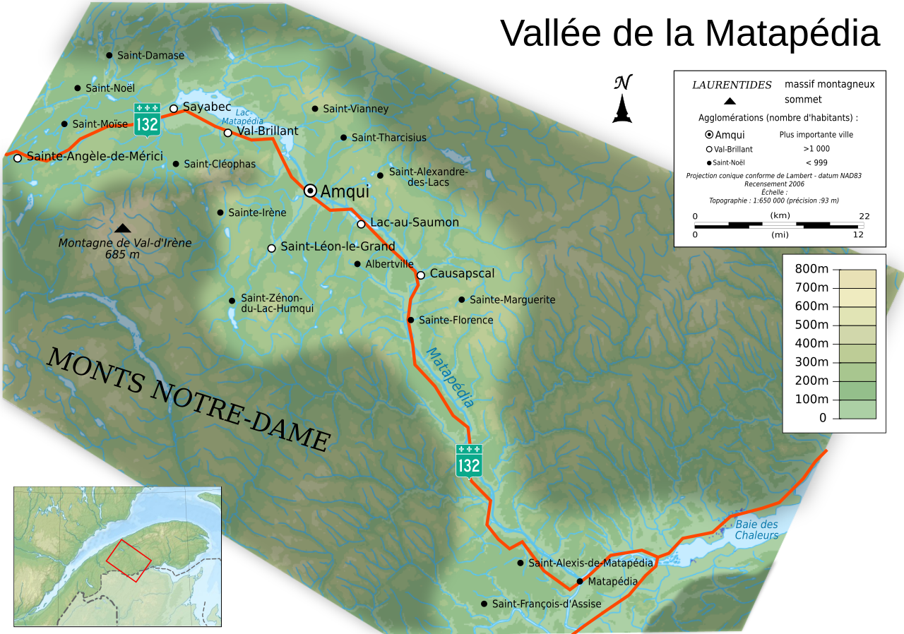
Français : Carte topographique en français de la Vallée de la Matapédia, Québec, avec agglomérations suivant le recensement de 2006.
|
| Date | |
| Source |
Own work ;
|
| Author | Chicoutimi |
| Permission (Reusing this file) |
User:Chicoutimi/Credits |
| Other versions |
[]
Same base map but with topography and without transportation:
Same map, but with an extra layer containing locations of Hydro-Québec's generating stations and 735 kV lines and substations
|


| This SVG file contains embedded text that can be translated into your language, using any capable SVG editor, text editor or the SVG Translate tool. For more information see: About translating SVG files. |
Licensing
I, the copyright holder of this work, hereby publish it under the following licenses:

|
Permission is granted to copy, distribute and/or modify this document under the terms of the GNU Free Documentation License, Version 1.2 or any later version published by the Free Software Foundation; with no Invariant Sections, no Front-Cover Texts, and no Back-Cover Texts. A copy of the license is included in the section entitled GNU Free Documentation License. |
This file is licensed under the Creative Commons Attribution-Share Alike 4.0 International, 3.0 Unported, 2.5 Generic, 2.0 Generic and 1.0 Generic license.
- You are free:
- to share – to copy, distribute and transmit the work
- to remix – to adapt the work
- Under the following conditions:
- attribution – You must give appropriate credit, provide a link to the license, and indicate if changes were made. You may do so in any reasonable manner, but not in any way that suggests the licensor endorses you or your use.
- share alike – If you remix, transform, or build upon the material, you must distribute your contributions under the same or compatible license as the original.
You may select the license of your choice.
File history
Click on a date/time to view the file as it appeared at that time.
| Date/Time | Thumbnail | Dimensions | User | Comment | |
|---|---|---|---|---|---|
| current | 23:03, 26 October 2009 | | 1,152 × 808 (1.35 MB) | Adqproductions | topo |
| 22:03, 26 October 2009 |  | 1,152 × 808 (1.34 MB) | Adqproductions | images embeded | |
| 22:02, 26 October 2009 |  | 1,152 × 808 (98 KB) | Adqproductions | == {{int:filedesc}} == {{Location|48|30|00|N|67|20|00|W|scale:600000}} <br/> {{Information |Description={{en|Topographic map in French of en:Matapedia, Quebec, with 2006' census cities.}} {{fr|Carte topographique en français du [[:fr: |
File usage
The following page uses this file:
Global file usage
The following other wikis use this file: