
File:Uganda Protectorate British administration.png

Size of this preview: 528 × 600 pixels. Other resolutions: 211 × 240 pixels | 422 × 480 pixels | 661 × 751 pixels.
Original file (661 × 751 pixels, file size: 18 KB, MIME type: image/png)
| This is a file from the Wikimedia Commons. Information from its description page there is shown below. Commons is a freely licensed media file repository. You can help. |
Summary
| Description |
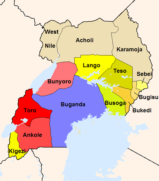
English: The map shows the British administration units in the Uganda Protectorate (borders of 1926).
The reddish areas and the blue Buganda are areas, where traditional kingdoms were maintained. In the yellowish areas Baganda-type administration was introduced. The khaki areas had no sole traditional rule before. |
| Source |
Own work
|
| Author | Slomox |
Licensing
| I, the copyright holder of this work, release this work into the public domain. This applies worldwide. In some countries this may not be legally possible; if so: I grant anyone the right to use this work for any purpose, without any conditions, unless such conditions are required by law. |
File history
Click on a date/time to view the file as it appeared at that time.
| Date/Time | Thumbnail | Dimensions | User | Comment | |
|---|---|---|---|---|---|
| current | 00:44, 22 February 2008 | | 661 × 751 (18 KB) | Mahahahaneapneap | pngcrushed |
| 20:34, 18 September 2005 |  | 661 × 751 (34 KB) | Slomox | little correction | |
| 19:36, 18 September 2005 |  | 661 × 751 (33 KB) | Slomox | The map shows the British administration units in the Uganda Protectorate (borders of 1926). The map is based on data given in ''A History of East Africa'' by Odhiambo, Ouso and Williams. The reddish areas and the blue Buganda are areas, where traditiona |
File usage
The following 7 pages use this file:
Global file usage
The following other wikis use this file:
- Usage on als.wikipedia.org
- Usage on de.wikipedia.org
- Usage on es.wikipedia.org
- Usage on fr.wikipedia.org
- Usage on io.wikipedia.org
- Usage on it.wikipedia.org
- Usage on ja.wikipedia.org
- Usage on lt.wikipedia.org
- Usage on no.wikipedia.org
- Usage on pt.wikipedia.org
- Usage on ru.wikipedia.org
- Usage on uk.wikipedia.org
- Usage on vec.wikipedia.org