
File:Porquerolles topographic map-fr.svg

Size of this PNG preview of this SVG file: 800 × 563 pixels. Other resolutions: 320 × 225 pixels | 640 × 451 pixels | 1,024 × 721 pixels | 1,280 × 901 pixels | 2,560 × 1,802 pixels | 1,027 × 723 pixels.
Original file (SVG file, nominally 1,027 × 723 pixels, file size: 1.15 MB)
| This is a file from the Wikimedia Commons. Information from its description page there is shown below. Commons is a freely licensed media file repository. You can help. |
| Description |
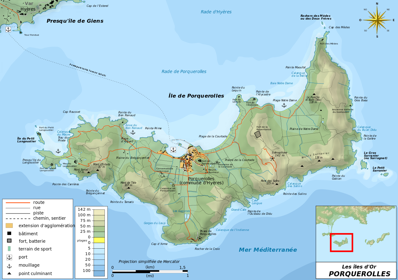
Français : Carte topographique et administrative en français de Porquerolles, l'une des trois Îles d'Or, ou Îles d'Hyères. Deutsch: Topographische Karte / Verwaltungskarte zum Porquerolles, in Französische English: Topographic and administrative map in French of Porquerolles Español: Mapa topográfico y administrativo en francès de Porquerolles Italiano: Carta topografica e amministrativa de Porquerolles 日本語: フランス語で表示したPorquerollesの地形·行政地図 Português: Carta topográfica e da administração do Porquerolles em francês |
||||
| Date | |||||
| Source |
Français : Création personnelle ;
English: Own work;
|
||||
| Author | Bourrichon - fr:Bourrichon | ||||
| Permission (Reusing this file) |
I, the copyright holder of this work, hereby publish it under the following licenses:
This file is licensed under the Creative Commons Attribution-Share Alike 3.0 Unported, 2.5 Generic, 2.0 Generic and 1.0 Generic license.
You may select the license of your choice. |
||||
| Other versions | Template:Other versions/Porquerolles map |

| This SVG file contains embedded text that can be translated into your language, using any capable SVG editor, text editor or the SVG Translate tool. For more information see: About translating SVG files. |
This W3C-unspecified vector image was created with Inkscape .
File history
Click on a date/time to view the file as it appeared at that time.
| Date/Time | Thumbnail | Dimensions | User | Comment | |
|---|---|---|---|---|---|
| current | 10:27, 25 February 2011 | | 1,027 × 723 (1.15 MB) | Bourrichon | harmonisation bathymétrie |
| 10:04, 13 December 2010 |  | 1,027 × 723 (1.15 MB) | Hektor | Added Mas du Langoustier | |
| 13:27, 13 November 2010 |  | 1,027 × 723 (1.15 MB) | Bourrichon | +corr orth => "Rade d'Hyères" | |
| 13:08, 13 November 2010 |  | 1,027 × 723 (1.15 MB) | Bourrichon | +erreur dans le nom de la projection => proj. simplifiée de Mercator | |
| 12:48, 13 November 2010 |  | 1,027 × 723 (1.15 MB) | Bourrichon | +correction de détails | |
| 21:18, 4 November 2010 |  | 1,027 × 723 (1.13 MB) | Bourrichon | debug | |
| 16:43, 3 November 2010 |  | 1,027 × 723 (1.15 MB) | Bourrichon | +Bathymétrie | |
| 19:08, 2 November 2010 |  | 1,003 × 723 (1.09 MB) | Bourrichon | embedded raster | |
| 19:05, 2 November 2010 |  | 1,003 × 723 (1.09 MB) | Bourrichon | +titre | |
| 18:36, 2 November 2010 |  | 1,003 × 723 (1.09 MB) | Bourrichon | debug |
File usage
The following 2 pages use this file:
Global file usage
The following other wikis use this file:
- Usage on da.wikipedia.org
- Usage on de.wikipedia.org
- Usage on el.wikipedia.org
- Usage on fr.wikipedia.org
- Usage on it.wikipedia.org
- Usage on lb.wikipedia.org
- Usage on nl.wikipedia.org
- Usage on no.wikipedia.org
- Usage on oc.wikipedia.org
- Usage on pl.wikipedia.org
- Usage on pl.wikivoyage.org
- Usage on pt.wikipedia.org
- Usage on ru.wikipedia.org
- Usage on sv.wikipedia.org
- Usage on tg.wikipedia.org
- Usage on uk.wikipedia.org