
File:PixieWoods.jpg

Size of this preview: 800 × 565 pixels. Other resolutions: 320 × 226 pixels | 640 × 452 pixels | 1,024 × 724 pixels | 1,280 × 905 pixels | 2,200 × 1,555 pixels.
Original file (2,200 × 1,555 pixels, file size: 519 KB, MIME type: image/jpeg)
| This is a file from the Wikimedia Commons. Information from its description page there is shown below. Commons is a freely licensed media file repository. You can help. |
Summary
| Description |
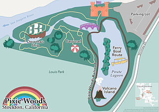
English: Map of Pixie Woods Amusement Park in Stockton, CA
Map created by Laura Daly, using QGIS, Adobe Illustrator Data Sources: OpenStreetMap; City of Stockton GIS; California Protected Lands Database (CPAD); visitstockton.org Projection: WGS 84 (though the large scale of the map makes this not very useful information) |
| Date | |
| Source | Unpublished original work. Emailed directly to me for posting by the author. |
| Author | Laura Daly |
| Permission (Reusing this file) |
|
Licensing
This file is licensed under the Creative Commons Attribution-Share Alike 4.0 International license.
- You are free:
- to share – to copy, distribute and transmit the work
- to remix – to adapt the work
- Under the following conditions:
- attribution – You must give appropriate credit, provide a link to the license, and indicate if changes were made. You may do so in any reasonable manner, but not in any way that suggests the licensor endorses you or your use.
- share alike – If you remix, transform, or build upon the material, you must distribute your contributions under the same or compatible license as the original.
File history
Click on a date/time to view the file as it appeared at that time.
| Date/Time | Thumbnail | Dimensions | User | Comment | |
|---|---|---|---|---|---|
| current | 20:58, 4 September 2015 | | 2,200 × 1,555 (519 KB) | Munion | Author added locator map. |
| 02:09, 2 September 2015 |  | 2,000 × 1,413 (433 KB) | Munion | User created page with UploadWizard |
File usage
The following page uses this file: