
File:Padum Zanskar View From Karsha Oct22 A7C 03984.jpg

Size of this preview: 800 × 533 pixels. Other resolutions: 320 × 213 pixels | 640 × 427 pixels | 1,024 × 683 pixels | 1,280 × 853 pixels | 2,560 × 1,707 pixels | 5,713 × 3,809 pixels.
Original file (5,713 × 3,809 pixels, file size: 15.76 MB, MIME type: image/jpeg)
| This is a file from the Wikimedia Commons. Information from its description page there is shown below. Commons is a freely licensed media file repository. You can help. |
Summary
| Description |
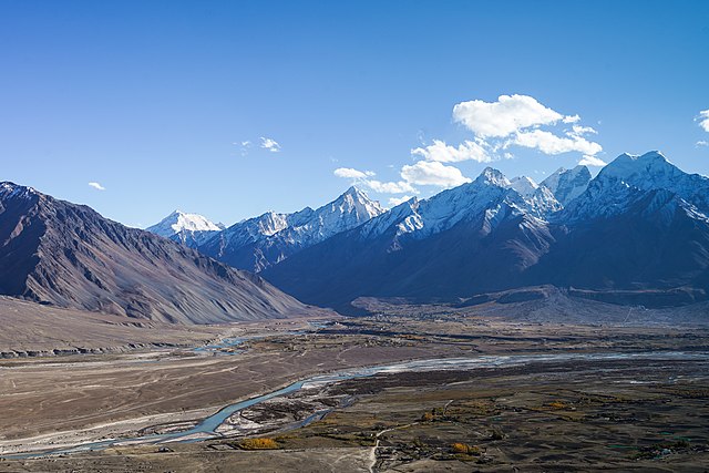
English: Padum town, surrounding villages and Zanskar Range, view towards south-southwest from Karsha Gompa. Stod-Doda river flowing right to left, Tsarap River centre to left. Padum elev. 3,660 m (12,010 ft), peak elev. about 6,000 m (20,000 ft). Zanskar, Ladakh, India
Українська: Хребет Занскар в Індійських Гімалаях височіє на 2400 м над містом Падам (на висоті 3660 м) у Занскарі, Ладакх. Річка Стод-Дода тече справа через долину Падум, впадає в річку Царап, яка тече з центру наліво. |
|||
| Date | ||||
| Source | Own work | |||
| Author |
|

| Camera location | | View this and other nearby images on: OpenStreetMap |
|---|
Assessment
|
This image has been selected as picture of the day on Wikimedia Commons for 14 February 2025. It will be captioned as follows: English: The Zanskar Range of the Indian Himalayas towers 2,400 m (8,000 ft) over Padum town in Zanskar, Ladakh. The elevation of Padum is 3,660 m (12,010 ft). The Stod-Doda river flows from the right across the Padum valley, merges into the Tsarap River which flows from centre to left. Other languages:
Deutsch: Die indische Stadt Padum vor dem Zanskargebirge. Der Lungnak und der Stod vereinigen sich hier zum Zanskar. English: The Zanskar Range of the Indian Himalayas towers 2,400 m (8,000 ft) over Padum town in Zanskar, Ladakh. The elevation of Padum is 3,660 m (12,010 ft). The Stod-Doda river flows from the right across the Padum valley, merges into the Tsarap River which flows from centre to left. Español: La cadena de Zanskar en el Himalaya indio se eleva 2400 m sobre la villa de Padum en Zanskar, Ladaj. La altitud de Padum es de 3660 m s.n.m. El río Stod-Doda fluye desde la derecha a través del valle de Padum y se une al río Tsarap, que fluye desde el centro hacia la izquierda. Euskara: Zanskar mendikatea, Ladakh eskualdean, 2400 m garai Padum haranaren gainean. Padum 3660 m dago itsaso mailatik gora. Français : Dans l'Himalaya indien, le Zanskar culmine à 2400m au-dessus de Padum. Padum se situe à 3660m d'altitude. Le Doda s'écoule depuis la droite à travers la vallée et se jette dans le Tsarap, qui coule du centre vers la gauche de la photo. Italiano: I Monti Zaskar appartenenti al complesso dell'Himalaya si elevano per 2400 m dalla piana di Padum, nel tehsil di Zanskar, nel territorio indiano del Ladakh. Il villaggio di Padum si trova a sua volta a 3660 m s.l.m. La valle è attravesata dal fiume Tsarap (che scorre dal centro dell'immagine verso sinistra) e dal suo tributario Stod-Doda, che attraversa l'altopiano nell'immagine da destra a sinistra. Magyar: Az indiai Himalája Zanszkár-hegységének hegyvonulata 2400 méter magasan emelkedik Padum városa fölé. Padum tengerszint feletti magassága 3660 méter. A Stod-Doda folyó jobbról folyik át a Padum-völgyön, majd beleolvad a Tsarap folyóba, amely középen folyik balra (Ladak, Zanszkár, India) Português: Cordilheira de Zanskar, no Himalaia indiano, eleva-se a 2 400 m sobre a cidade de Padum, em Zanskar, Ladaque. A elevação de Padum é de 3 660 m. O rio Stod-Doda flui da direita pelo vale de Padum e se funde com o rio Tsarap, que flui do centro para a esquerda. Македонски: Венецот Занскар на Хималаите над паланката Падам во Ладак, Индија. Українська: Хребет Занскар в Індійських Гімалаях височіє на 2400 м над містом Падам (на висоті 3660 м) у Занскарі, Ладакх. Річка Стод-Дода тече справа через долину Падум, впадає в річку Царап, яка тече з центру наліво. |
This image has been assessed using the Quality image guidelines and is considered a Quality image.
|
Licensing
I, the copyright holder of this work, hereby publish it under the following license:
This file is licensed under the Creative Commons Attribution-Share Alike 4.0 International license.
- You are free:
- to share – to copy, distribute and transmit the work
- to remix – to adapt the work
- Under the following conditions:
- attribution – You must give appropriate credit, provide a link to the license, and indicate if changes were made. You may do so in any reasonable manner, but not in any way that suggests the licensor endorses you or your use.
- share alike – If you remix, transform, or build upon the material, you must distribute your contributions under the same or compatible license as the original.
File history
Click on a date/time to view the file as it appeared at that time.
| Date/Time | Thumbnail | Dimensions | User | Comment | |
|---|---|---|---|---|---|
| current | 02:25, 29 November 2022 | | 5,713 × 3,809 (15.76 MB) | Tagooty | c:User:Rillke/bigChunkedUpload.js: Tweaked exposure |
| 15:00, 28 November 2022 |  | 5,713 × 3,809 (14.54 MB) | Tagooty | Uploaded own work with UploadWizard |
File usage
The following 3 pages use this file:
Global file usage
The following other wikis use this file:
- Usage on av.wikipedia.org
- Usage on bdr.wikipedia.org
- Usage on bn.wikipedia.org
- Usage on de.wikipedia.org
- Usage on es.wikipedia.org
- Usage on fr.wikipedia.org
- Usage on hu.wikipedia.org
- Usage on kk.wikipedia.org
- Usage on ko.wikipedia.org
- Usage on lez.wikipedia.org
- Usage on mk.wikipedia.org
- Usage on pt.wikipedia.org
- Usage on ru.wikipedia.org
- Usage on sah.wikipedia.org
- Usage on uk.wikipedia.org
- Usage on vep.wikipedia.org
- Usage on xmf.wikipedia.org
- Usage on zh.wikipedia.org