
File:PIA15276 Locator Map for 'Greeley Haven' on Endeavour Rim.jpg

No higher resolution available.
PIA15276_Locator_Map_for_'Greeley_Haven'_on_Endeavour_Rim.jpg (700 × 560 pixels, file size: 55 KB, MIME type: image/jpeg)
| This is a file from the Wikimedia Commons. Information from its description page there is shown below. Commons is a freely licensed media file repository. You can help. |
Summary
| Description |
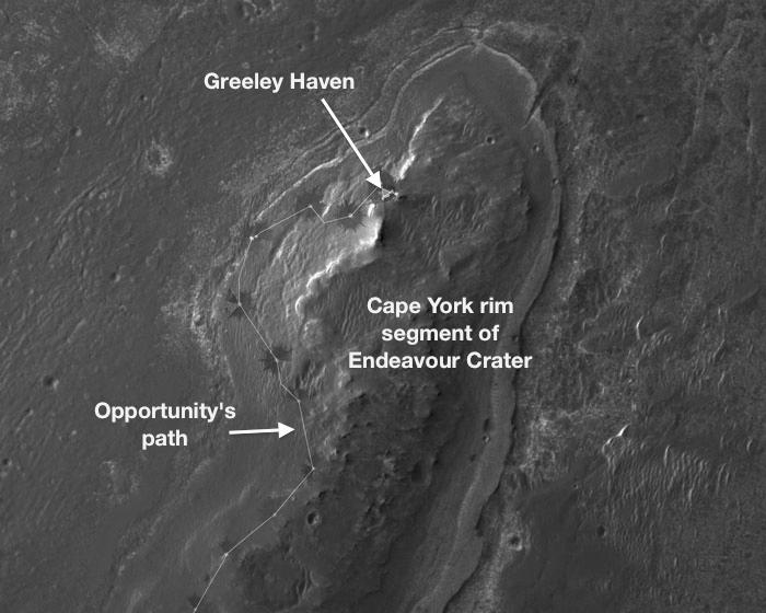
English: NASA's Mars Exploration Rover Opportunity will spend its fifth Martian winter working at a location informally named "Greeley Haven." This site is an outcrop near the northern tip of the "Cape York" segment of the western rim of Endeavour Crater. It provides a north-facing slope of 15 degrees or more to aid electric output from Opportunity's solar array. It also presents geological targets of interest for investigating during months of limited mobility while the rover stays on the slope.
This image, covering an area about 2,000 feet (about 600 meters) wide, indicates the location of Greeley Haven on Cape York. The base image of the map is a portion of an image taken by the High Resolution Imaging Science Experiment (HiRISE) instrument on NASA's Mars Reconnaissance Orbiter, on July 23, 2010. Other image products from this observation are available at http://hirise.lpl.arizona.edu/ESP_018701_1775. NASA's Jet Propulsion Laboratory, a division of the California Institute of Technology, Pasadena, manages the Mars Exploration Rover Project and the Mars Reconnaissance Orbiter Project for the NASA Science Mission Directorate, Washington.The University of Arizona, Tucson, operates the HiRISE camera, which was built by Ball Aerospace & Technologies Corp., Boulder, Colo. Lockheed Martin Space Systems, Denver, is the spacecraft development and integration contractor for the project and built the spacecraft. |
| Date | (published 5 January 2012) |
| Source | Catalog page · Full-res (JPEG · TIFF) |
| Author | NASA/JPL-Caltech/UA |
| Location on Mars | View this and other nearby images on: Google Maps |
|---|
This image or video was catalogued by Jet Propulsion Laboratory of the United States National Aeronautics and Space Administration (NASA) under Photo ID: PIA15276. This tag does not indicate the copyright status of the attached work. A normal copyright tag is still required. See Commons:Licensing. Other languages:
|
 |
This media is a product of the Mars Reconnaissance Orbiter mission Credit and attribution belongs to the mission team, if not already specified in the "author" row |
Licensing
| This file is in the public domain in the United States because it was solely created by NASA. NASA copyright policy states that "NASA material is not protected by copyright unless noted". (See Template:PD-USGov, NASA copyright policy page or JPL Image Use Policy.) | ||
 |
Warnings:
|
File history
Click on a date/time to view the file as it appeared at that time.
| Date/Time | Thumbnail | Dimensions | User | Comment | |
|---|---|---|---|---|---|
| current | 20:47, 7 January 2017 | | 700 × 560 (55 KB) | PhilipTerryGraham | Original resolution. Previous version was an upscale. |
| 20:43, 16 June 2012 |  | 946 × 710 (175 KB) | MoreInput | {{Information |Description ={{en|1=Locator Map for 'Greeley Haven' on Endeavour Rim}} {{de|1=Karte der Position von Opportunity bei 'Greeley Haven' am Rand des Endeavour Kraters}} |Source =http://www.nasa.gov/mission_pages/mer/multimedia/pia... |
File usage
The following 2 pages use this file: