
File:Orographie-Sabah-Kinabatangan.png
Size of this preview: 800 × 557 pixels. Other resolutions: 320 × 223 pixels | 640 × 445 pixels | 1,024 × 713 pixels | 1,280 × 891 pixels | 2,560 × 1,782 pixels | 3,000 × 2,088 pixels.
Original file (3,000 × 2,088 pixels, file size: 1.7 MB, MIME type: image/png)
| This is a file from the Wikimedia Commons. Information from its description page there is shown below. Commons is a freely licensed media file repository. You can help. |
Summary
| Description |
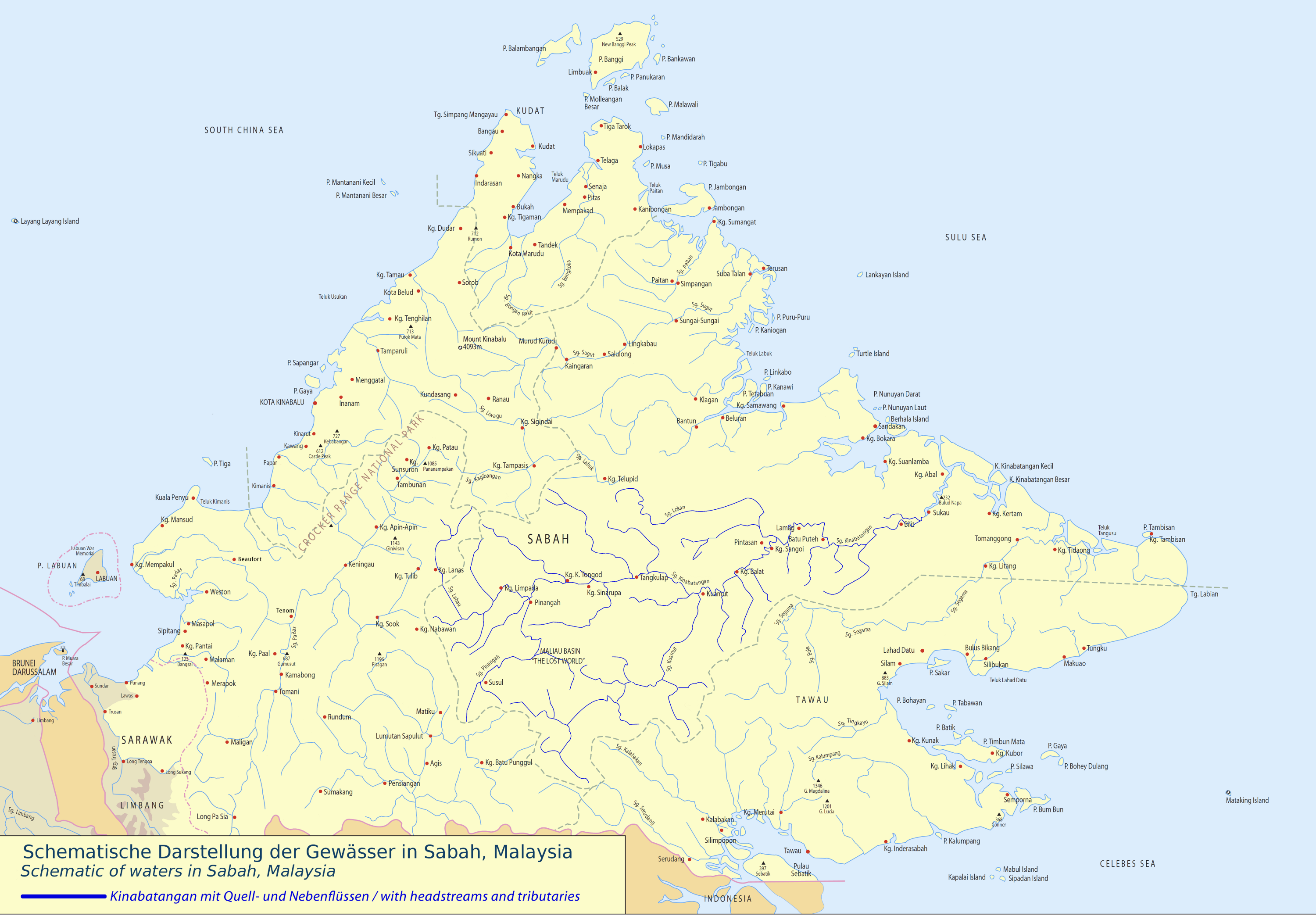
English: Schematic of waters in Sabah, Malaysia: KINABATANGAN with headstreams and tributaries
Deutsch: Schematische Darstellung der Gewässer in Sabah, Malaysia: KINABATANGAN mit Quell- und Nebenflüssen |
| Date | |
| Source | Own work |
| Author | Cccefalon |
Licensing
I, the copyright holder of this work, hereby publish it under the following license:
This file is licensed under the Creative Commons Attribution-Share Alike 3.0 Unported license.
- You are free:
- to share – to copy, distribute and transmit the work
- to remix – to adapt the work
- Under the following conditions:
- attribution – You must give appropriate credit, provide a link to the license, and indicate if changes were made. You may do so in any reasonable manner, but not in any way that suggests the licensor endorses you or your use.
- share alike – If you remix, transform, or build upon the material, you must distribute your contributions under the same or compatible license as the original.
File history
Click on a date/time to view the file as it appeared at that time.
| Date/Time | Thumbnail | Dimensions | User | Comment | |
|---|---|---|---|---|---|
| current | 19:15, 24 January 2012 | | 3,000 × 2,088 (1.7 MB) | Cccefalon | {{Information |Description ={{en|1=Schematic of waters in Sabah, Malaysia: KINABATANGAN with headstreams and tributaries}} {{de|1=Schematische Darstellung der Gewässer in Sabah, Malaysia: KINABATANGAN mit Quell- und Nebenflüssen}} |Source ={{ |
File usage
The following page uses this file:
Global file usage
The following other wikis use this file:
- Usage on de.wikipedia.org
- Usage on dtp.wikipedia.org
- Usage on fr.wikipedia.org
- Usage on it.wikipedia.org
- Usage on ja.wikipedia.org
- Usage on ml.wikipedia.org
- Usage on ms.wikipedia.org
- Usage on pt.wikipedia.org
- Usage on ru.wikipedia.org
- Usage on www.wikidata.org