
File:Mapa zeleznicnych trati ZSR ENG.png

Size of this preview: 800 × 384 pixels. Other resolutions: 320 × 153 pixels | 640 × 307 pixels | 1,460 × 700 pixels.
Original file (1,460 × 700 pixels, file size: 334 KB, MIME type: image/png)
| This is a file from the Wikimedia Commons. Information from its description page there is shown below. Commons is a freely licensed media file repository. You can help. |

|
File:Railways Slovakia SK.svg is a vector version of this file. It should be used in place of this PNG file when not inferior.
File:Mapa zeleznicnych trati ZSR ENG.png → File:Railways Slovakia SK.svg
For more information, see Help:SVG. |
 |
| Description |
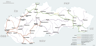
English: Map of ŽSR Railway Lines with English. |
||
| Source | Own work | ||
| Author | ENG-N1 | ||
| Permission (Reusing this file) |
|
File history
Click on a date/time to view the file as it appeared at that time.
| Date/Time | Thumbnail | Dimensions | User | Comment | |
|---|---|---|---|---|---|
| current | 13:41, 1 November 2010 | | 1,460 × 700 (334 KB) | ENG-N1 | correct |
| 15:37, 21 October 2010 |  | 1,460 × 700 (333 KB) | ENG-N1 | {{Information |Description={{en|1=Map of ŽSR Railway Lines with English.}} |Source=Self made |Author=ENG-N1 |Date= |Permission={{PD-Self}} |other_versions= }} Category:Rail transport maps of Slovakia |
File usage
The following page uses this file:
Global file usage
The following other wikis use this file:
- Usage on az.wikipedia.org
- Usage on de.wikipedia.org
- Usage on es.wikipedia.org
- Usage on fi.wikipedia.org
- Usage on fr.wikipedia.org
- Usage on fr.wikivoyage.org
- Usage on it.wikipedia.org
- Usage on it.wikivoyage.org
- Usage on rm.wikipedia.org
- Usage on ro.wikipedia.org
- Usage on ru.wikipedia.org
- Usage on th.wikipedia.org
- Usage on uk.wikipedia.org
- Usage on www.wikidata.org
- Usage on zh.wikipedia.org