
File:Map of Ming Chinese empire 1415 (cropped).jpg

Size of this preview: 396 × 599 pixels. Other resolutions: 159 × 240 pixels | 317 × 480 pixels | 508 × 768 pixels | 677 × 1,024 pixels | 1,440 × 2,178 pixels.
Original file (1,440 × 2,178 pixels, file size: 389 KB, MIME type: image/jpeg)
| This is a file from the Wikimedia Commons. Information from its description page there is shown below. Commons is a freely licensed media file repository. You can help. |
Summary
| Author |
Albert Herrmann & Georg Westermann |
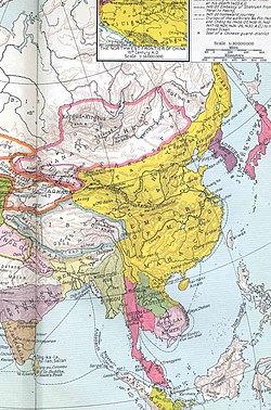
| Description |
English: Detail of the eastern portion of the map of the Ming Empire (yellow) under the Yongle Emperor in the year 1415. Inset map of the Northwestern Frontier of China 15th Century A.D. |
| Date | 1935 |
| Source/Photographer | Historical and Commercial Atlas of China |
| Other versions |
|

.jpg)
Licensing
|
This is a faithful photographic reproduction of a two-dimensional, public domain work of art. The work of art itself is in the public domain in its source country for the following reason:
It is also in the public domain in the United States for the following reason:
The official position taken by the Wikimedia Foundation is that "faithful reproductions of two-dimensional public domain works of art are public domain".
This photographic reproduction is therefore also considered to be in the public domain in the United States. In other jurisdictions, re-use of this content may be restricted; see Reuse of PD-Art photographs for details.
| |||||||

.jpg)
File history
Click on a date/time to view the file as it appeared at that time.
| Date/Time | Thumbnail | Dimensions | User | Comment | |
|---|---|---|---|---|---|
| current | 07:57, 28 March 2018 | | 1,440 × 2,178 (389 KB) | ديفيد عادل وهبة خليل 2 | Removed border from File:Map of Ming Chinese empire 1415.jpg by cropping 9 % horizontally and 7 % vertically using CropTool with precise mode. |
File usage
The following 2 pages use this file:
Global file usage
The following other wikis use this file:
- Usage on de.wikipedia.org
- Usage on eu.wikipedia.org
- Usage on frr.wikipedia.org
- Usage on ky.wikipedia.org
- Usage on mn.wikipedia.org
- Usage on nds.wikipedia.org
- Usage on ru.wikipedia.org
- Usage on simple.wikipedia.org
- Usage on si.wikipedia.org
- Usage on su.wikipedia.org
- Usage on vi.wikipedia.org
- Usage on zh.wikipedia.org
.jpg)