
File:Map of Maine highlighting York County.svg

Size of this PNG preview of this SVG file: 400 × 600 pixels. Other resolutions: 160 × 240 pixels | 320 × 480 pixels | 512 × 768 pixels | 683 × 1,024 pixels | 1,366 × 2,048 pixels | 723 × 1,084 pixels.
Original file (SVG file, nominally 723 × 1,084 pixels, file size: 71 KB)
| This is a file from the Wikimedia Commons. Information from its description page there is shown below. Commons is a freely licensed media file repository. You can help. |
Summary
| Description |
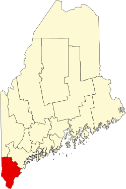
English: This is a locator map showing York County in Maine. For more information, see Commons:United States county locator maps. |
| Date | |
| Source |
Own work: English: The maps use data from nationalatlas.gov, specifically countyp020.tar.gz on the Raw Data Download page. The maps also use state outline data from statesp020.tar.gz. The Florida maps use hydrogm020.tar.gz to display Lake Okeechobee. |
| Author | David Benbennick |
Licensing
| I, the copyright holder of this work, release this work into the public domain. This applies worldwide. In some countries this may not be legally possible; if so: I grant anyone the right to use this work for any purpose, without any conditions, unless such conditions are required by law. |
File history
Click on a date/time to view the file as it appeared at that time.
| Date/Time | Thumbnail | Dimensions | User | Comment | |
|---|---|---|---|---|---|
| current | 21:33, 24 June 2024 | | 723 × 1,084 (71 KB) | Nux | fix rendering (remove clipping) |
| 12:48, 12 February 2006 |  | 3,252 × 4,876 (131 KB) | David Benbennick | {{subst:User:Dbenbenn/clm|county=York County|state=Maine|type=county}} |
File usage
The following 72 pages use this file:
- Acton, Maine
- Alfred, Maine
- Alfred (CDP), Maine
- Arundel, Maine
- Bald Head, Maine
- Bar Mills, Maine
- Bedell Crossing, Maine
- Berwick, Maine
- Berwick (CDP), Maine
- Biddeford, Maine
- Biddeford Pool
- Buxton, Maine
- Cape Neddick, Maine
- Cape Porpoise, Maine
- Cornish, Maine
- Cornish (CDP), Maine
- Dayton, Maine
- East Parsonsfield, Maine
- East Waterboro, Maine
- Eliot, Maine
- Felch Corner, Maine
- Fort McClary
- Hills Beach
- Hollis, Maine
- Kennebunk, Maine
- Kennebunk (CDP), Maine
- Kennebunkport, Maine
- Kennebunkport (CDP), Maine
- Kezar Falls, Maine
- Kittery, Maine
- Kittery (CDP), Maine
- Kittery Point, Maine
- Lake Arrowhead, Maine
- Lebanon, Maine
- Limerick, Maine
- Limington, Maine
- List of counties in Maine
- Lyman, Maine
- Moody Beach, Maine
- National Register of Historic Places listings in York County, Maine
- Newfield, Maine
- North Berwick, Maine
- North Berwick (CDP), Maine
- Ocean Park, Maine
- Ogunquit, Maine
- Old Orchard Beach, Maine
- Parsonsfield, Maine
- Perkins Cove
- Portsmouth Naval Prison
- Portsmouth Naval Shipyard
- Saco, Maine
- Sanford, Maine
- Sanford (CDP), Maine
- Shapleigh, Maine
- South Berwick, Maine
- South Berwick (CDP), Maine
- South Eliot, Maine
- South Sanford, Maine
- Springvale, Maine
- Waterboro, Maine
- Wells, Maine
- West Kennebunk, Maine
- York, Maine
- York Beach, Maine
- York Cliffs, Maine
- York County, Maine
- York Harbor, Maine
- User:AridCeption/sandbox
- User:Nyttend/County templates/ME
- File talk:Map of Maine highlighting York County.svg
- Template:York County, Maine
- Category:Populated places in York County, Maine
Global file usage
The following other wikis use this file:
- Usage on ar.wikipedia.org
- Usage on azb.wikipedia.org
- Usage on be.wikipedia.org
- Usage on bg.wikipedia.org
- Usage on bpy.wikipedia.org
- Usage on ca.wikipedia.org
- Acton (Maine)
- Alfred (Maine)
- Arundel
- Berwick (Maine)
- Biddeford
- Cornish (Maine)
- Dayton (Maine)
- Eliot
- Hollis (Maine)
- Kennebunk
- Kennebunkport
- Kittery (Maine)
- Lebanon (Maine)
- Limington
- Lyman (Maine)
- Newfield (Maine)
- North Berwick
- Ogunquit
- Old Orchard Beach
- Parsonsfield
- Saco (Maine)
- Sanford (Maine)
- Shapleigh
- South Berwick
- Waterboro
- Wells (Maine)
- York (Maine)
- Plantilla:Comtat de York (Maine)
- Usage on cdo.wikipedia.org
- Usage on ceb.wikipedia.org
- Usage on ce.wikipedia.org
- Usage on cy.wikipedia.org
- Usage on de.wikipedia.org
View more global usage of this file.