
File:Map of Bulgaria and Eastern Rumelia in 1882.jpg

Size of this preview: 800 × 570 pixels. Other resolutions: 320 × 228 pixels | 640 × 456 pixels | 1,024 × 730 pixels | 1,420 × 1,012 pixels.
Original file (1,420 × 1,012 pixels, file size: 257 KB, MIME type: image/jpeg)
| This is a file from the Wikimedia Commons. Information from its description page there is shown below. Commons is a freely licensed media file repository. You can help. |
Summary
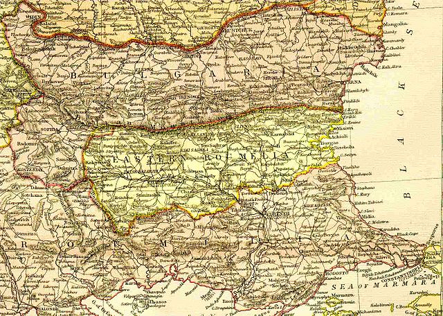
A map of the Principality of Bulgaria and Eastern Rumelia before the unification of Bulgaria in 1885. The map is from an 1882 atlas.
Image history at en:
(del) (cur) 09:01, 6 September 2005 . . TodorBozhinov . . 1420x1012 (263299 bytes) (A map of the Principality of...)
Licensing
|
This work is in the public domain in its country of origin and other countries and areas where the copyright term is the author's life plus 70 years or fewer. | |
| This file has been identified as being free of known restrictions under copyright law, including all related and neighboring rights. | |
File history
Click on a date/time to view the file as it appeared at that time.
| Date/Time | Thumbnail | Dimensions | User | Comment | |
|---|---|---|---|---|---|
| current | 01:33, 20 September 2005 | | 1,420 × 1,012 (257 KB) | Thuresson | A map of the Principality of Bulgaria and Eastern Rumelia before the unification of Bulgaria in 1885. The map is from an 1882 atlas. Image history at en: (del) (cur) 09:01, 6 September 2005 . . TodorBozhinov . . 1420x1012 (263 |
File usage
The following 3 pages use this file:
Global file usage
The following other wikis use this file:
- Usage on ar.wikipedia.org
- Usage on bg.wikipedia.org
- Usage on cs.wikipedia.org
- Usage on de.wikipedia.org
- Usage on et.wikipedia.org
- Usage on fa.wikipedia.org
- Usage on fr.wikipedia.org
- Usage on hr.wikipedia.org
- Usage on hu.wikipedia.org
- Usage on it.wikipedia.org
- Usage on ja.wikipedia.org
- Usage on ms.wikipedia.org
- Usage on no.wikipedia.org
- Usage on pnb.wikipedia.org
- Usage on pt.wikipedia.org
- Usage on ro.wikipedia.org
- Usage on ru.wikipedia.org
- Usage on sh.wikipedia.org
- Usage on sk.wikipedia.org
- Usage on sq.wikipedia.org
- Usage on sr.wikipedia.org
- Usage on sv.wikipedia.org
- Usage on tr.wikipedia.org
- Usage on ur.wikipedia.org