
File:Linguistic Map of Justinian I's Empire c. 560.png

Size of this preview: 800 × 593 pixels. Other resolutions: 320 × 237 pixels | 640 × 474 pixels | 1,024 × 759 pixels | 1,280 × 948 pixels | 1,486 × 1,101 pixels.
Original file (1,486 × 1,101 pixels, file size: 78 KB, MIME type: image/png)
| This is a file from the Wikimedia Commons. Information from its description page there is shown below. Commons is a freely licensed media file repository. You can help. |
Summary
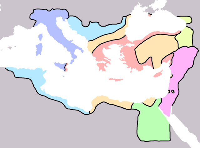
Map of the linguistic divisions in Justinian I's empire c. 560 AD.
Greek
Greek and native
Latin
Latin and native
Aramaic
Coptic
Armenian and Caucasian
. Made personally from blankmap Europe v3, using Mango, Cyril (2005) [1980] Byzantium: the Empire of the New Rome, London: Phoenix, pp. 14–15 ISBN: 1-89880-044-8. as a source.
Licensing
I, the copyright holder of this work, hereby publish it under the following license:
| This file is licensed under the Creative Commons Attribution-Share Alike 3.0 Unported license. Subject to disclaimers. | ||
| ||
| This licensing tag was added to this file as part of the GFDL licensing update. |

|
Permission is granted to copy, distribute and/or modify this document under the terms of the GNU Free Documentation License, Version 1.2 or any later version published by the Free Software Foundation; with no Invariant Sections, no Front-Cover Texts, and no Back-Cover Texts. A copy of the license is included in the section entitled GNU Free Documentation License. Subject to disclaimers. |
File history
Click on a date/time to view the file as it appeared at that time.
| Date/Time | Thumbnail | Dimensions | User | Comment | |
|---|---|---|---|---|---|
| current | 01:40, 16 October 2006 | | 1,486 × 1,101 (78 KB) | G.W. | Map of the linguistic divisions in Justinian I's empire c. 560 AD. Greek coloured in {{#FFB4B4}}, Greek and native in {{#FFE5B4}}, Latin in {{#B4C0FF}}, Latin and native in {{#B4E9FF}}, Aramic in {{#FFB4F9}}, Coptic in {{#BBFFB4}}, Caucasian in {{#EEFFB4} |
File usage
The following 4 pages use this file:
Global file usage
The following other wikis use this file:
- Usage on ca.wikipedia.org
- Usage on pt.wikipedia.org