
File:Karte Innsbruck - Katastralgemeinden und Statistische Stadtteile.png
Size of this preview: 435 × 599 pixels. Other resolutions: 174 × 240 pixels | 349 × 480 pixels | 558 × 768 pixels | 1,188 × 1,635 pixels.
Original file (1,188 × 1,635 pixels, file size: 435 KB, MIME type: image/png)
| This is a file from the Wikimedia Commons. Information from its description page there is shown below. Commons is a freely licensed media file repository. You can help. |
Summary
| Description |
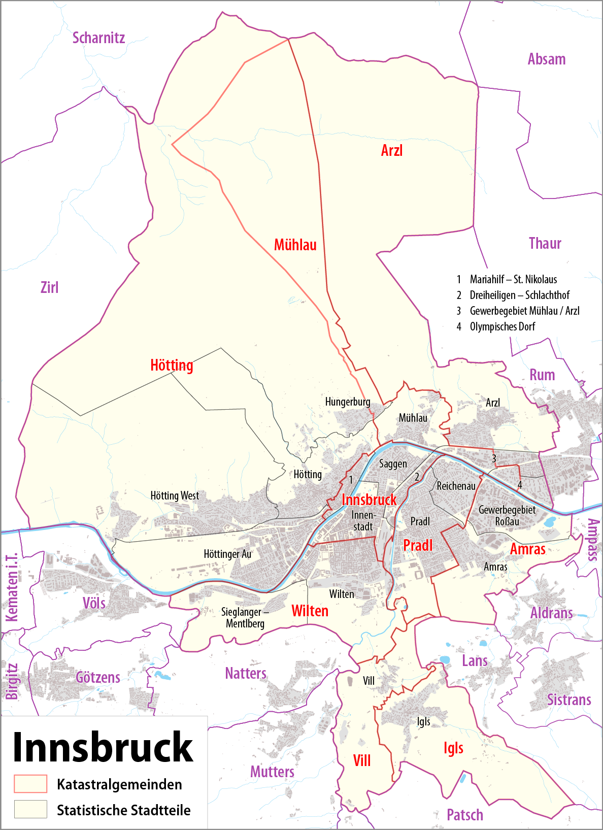
Deutsch: Karte von Innsbruck: Katastralgemeinden und statistische Stadtteile
English: Map of Innsbruck: cadastral communities and statistical districts |
|||
| Date | see file history | |||
| Source |
Own work, using
|
|||
| Author | Maximilian Dörrbecker (Chumwa) | |||
| Permission (Reusing this file) |
This file is licensed under the Creative Commons Attribution-Share Alike 2.0 Generic license.
Sie dürfen das Bild zu den folgenden Bedingungen nutzen:
|
|||
| Other versions |
Statistical districs of Innsbruck
Cadastral communities of Innsbruck
|


File history
Click on a date/time to view the file as it appeared at that time.
| Date/Time | Thumbnail | Dimensions | User | Comment | |
|---|---|---|---|---|---|
| current | 22:20, 7 June 2015 | | 1,188 × 1,635 (435 KB) | Cmdrjameson | Compressed with pngout. Reduced by 254kB (36% decrease). |
| 20:33, 3 September 2014 |  | 1,188 × 1,635 (690 KB) | Chumwa | ||
| 19:11, 8 August 2014 |  | 1,188 × 1,635 (689 KB) | Chumwa | ||
| 23:17, 7 August 2014 |  | 1,188 × 1,635 (634 KB) | Chumwa | ||
| 22:38, 7 August 2014 |  | 1,188 × 1,635 (633 KB) | Chumwa | == {{int:filedesc}} == {{Information |Description = {{de|1=Karte von Innsbruck: Katastralgemeinden und Statistische Stadtteile}} {{en|1=Map of Innsbruck: cadastral communities and statistic districts}} |Source={{own}}, using OpenStreetMap data f... |
File usage
The following page uses this file:
Global file usage
The following other wikis use this file:
- Usage on ca.wikipedia.org
- Usage on de.wikipedia.org
- Usage on et.wikipedia.org
- Usage on ga.wikipedia.org
- Usage on gl.wikipedia.org
- Usage on hy.wikipedia.org
- Usage on incubator.wikimedia.org
- Usage on lld.wikipedia.org
- Usage on rm.wikipedia.org
- Usage on tt.wikipedia.org
- Usage on vep.wikipedia.org
- Usage on vi.wikipedia.org
- Usage on www.wikidata.org