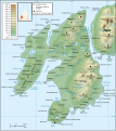
File:Islay topographic map-en.svg
Appearance

Size of this PNG preview of this SVG file: 533 × 600 pixels. Other resolutions: 213 × 240 pixels | 427 × 480 pixels | 683 × 768 pixels | 910 × 1,024 pixels | 1,820 × 2,048 pixels | 903 × 1,016 pixels.
Original file (SVG file, nominally 903 × 1,016 pixels, file size: 1.48 MB)
File history
Click on a date/time to view the file as it appeared at that time.
| Date/Time | Thumbnail | Dimensions | User | Comment | |
|---|---|---|---|---|---|
| current | 19:52, 20 November 2008 |  | 903 × 1,016 (1.48 MB) | Ayack | Corrections : Salige Bay → Saligo Bay, Beinn Bheigier → Beinn Bheigeir, Kildaton → Kildalton |
| 22:57, 12 February 2008 |  | 903 × 1,016 (1.48 MB) | Ayack | Retrait image oubliée | |
| 22:46, 12 February 2008 |  | 903 × 1,016 (5 MB) | Ayack | == Description == {{Location|55|45|41.8|N|6|15|43.9|W|scale:200000}} {{Information |Description={{en|Topographic map in French of Islay, Scotland.}}{{fr|Carte topographique de l'île d'Islay en [[:fr |
File usage
The following 3 pages use this file:
Global file usage
The following other wikis use this file:
- Usage on br.wikipedia.org
- Usage on de.wikipedia.org
- Usage on el.wikipedia.org
- Usage on es.wikipedia.org
- Usage on gl.wikipedia.org
- Usage on he.wikipedia.org
- Usage on ko.wikipedia.org
- Usage on nl.wikipedia.org
- Usage on nn.wikipedia.org
- Usage on no.wikipedia.org
- Usage on pl.wikipedia.org
- Usage on sv.wikipedia.org
- Usage on th.wikipedia.org
- Usage on tr.wikipedia.org


