
File:Fort Lyon Diagram.jpg

Size of this preview: 800 × 506 pixels. Other resolutions: 320 × 202 pixels | 640 × 404 pixels | 1,024 × 647 pixels | 1,280 × 809 pixels | 2,560 × 1,618 pixels | 4,203 × 2,656 pixels.
Original file (4,203 × 2,656 pixels, file size: 11.51 MB, MIME type: image/jpeg)
| This is a file from the Wikimedia Commons. Information from its description page there is shown below. Commons is a freely licensed media file repository. You can help. |
Summary
| Artist |
|
|||||||||||||||||||||||
| Description |
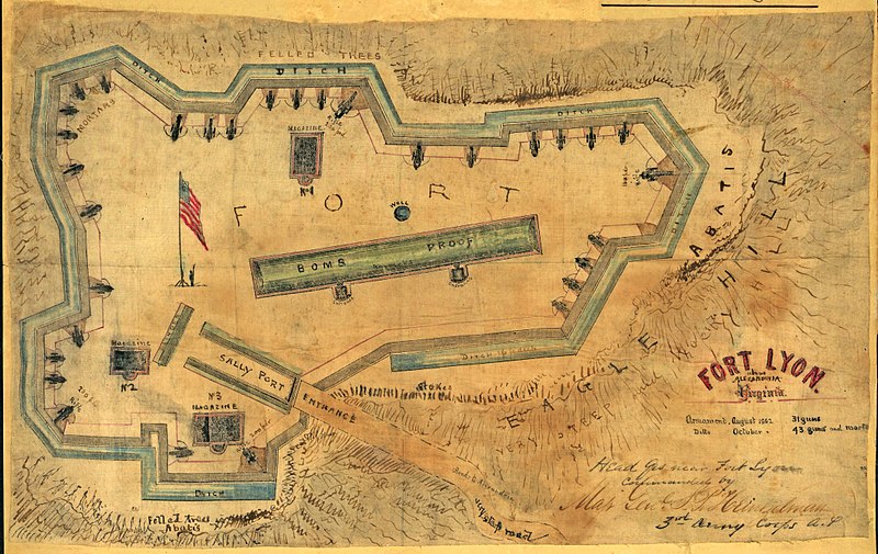
English: The map by Sneden, Robert Knox, 1832-1918, is a close up drawing of Fort Lyon located on Eagle Hill in Alexandria, Virginia. Shows the fort's defenses, including abatis, ditches, salients, sally port, and bomb proof. |
|||||||||||||||||||||||
| Date | 1862 | |||||||||||||||||||||||
| Source/Photographer |
http://hdl.loc.gov/loc.ndlpcoop/gvhs01.vhs00285
|
|||||||||||||||||||||||


Licensing
|
This is a faithful photographic reproduction of a two-dimensional, public domain work of art. The work of art itself is in the public domain for the following reason:
The official position taken by the Wikimedia Foundation is that "faithful reproductions of two-dimensional public domain works of art are public domain".
This photographic reproduction is therefore also considered to be in the public domain in the United States. In other jurisdictions, re-use of this content may be restricted; see Reuse of PD-Art photographs for details. | ||||
Wikipedia upload log
A previous Wikipedia upload had a description page here. All following user names refer to en.wikipedia.
- 2007-10-03 00:06 JKBrooks85 4203×2656× (12064788 bytes) The map shows a close up drawing of Fort Lyon located on Eagle Hill in Alexandria, Virginia. Shows the fort's defenses, including abatis, ditches, salients, sally port, and bomb proof. Sneden, Robert Knox, 1832-1918. This item is from the collections of
File history
Click on a date/time to view the file as it appeared at that time.
| Date/Time | Thumbnail | Dimensions | User | Comment | |
|---|---|---|---|---|---|
| current | 22:31, 3 February 2009 | | 4,203 × 2,656 (11.51 MB) | File Upload Bot (Magnus Manske) | {{BotMoveToCommons|en.wikipedia}} {{Information |Description={{en|The map shows a close up drawing of Fort Lyon located on Eagle Hill in Alexandria, Virginia. Shows the fort's defenses, including abatis, ditches, salients, sally port, and bomb proof. Sn |
File usage
The following 2 pages use this file:
Global file usage
The following other wikis use this file:
- Usage on www.wikidata.org