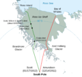
File:Antarctic expedition map (Amundsen - Scott)-en-crop.png
Appearance

Size of this preview: 637 × 600 pixels. Other resolutions: 255 × 240 pixels | 510 × 480 pixels | 816 × 768 pixels | 1,088 × 1,024 pixels | 1,446 × 1,361 pixels.
Original file (1,446 × 1,361 pixels, file size: 361 KB, MIME type: image/png)
File history
Click on a date/time to view the file as it appeared at that time.
| Date/Time | Thumbnail | Dimensions | User | Comment | |
|---|---|---|---|---|---|
| current | 20:04, 14 December 2016 |  | 1,446 × 1,361 (361 KB) | Soerfm | Lattitude |
| 15:03, 14 December 2016 |  | 1,446 × 1,361 (358 KB) | Soerfm | User created page with UploadWizard |
File usage
The following page uses this file:
Global file usage
The following other wikis use this file:
- Usage on fi.wikipedia.org
- Usage on mk.wikipedia.org
- Usage on sr.wikipedia.org
