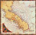
File:Adriatic map in Vesconte 1318 atlas.jpg
Appearance

Size of this preview: 627 × 600 pixels. Other resolutions: 251 × 240 pixels | 502 × 480 pixels | 803 × 768 pixels.
Original file (803 × 768 pixels, file size: 243 KB, MIME type: image/jpeg)
File history
Click on a date/time to view the file as it appeared at that time.
| Date/Time | Thumbnail | Dimensions | User | Comment | |
|---|---|---|---|---|---|
| current | 21:55, 19 June 2011 |  | 803 × 768 (243 KB) | Walrasiad | {{Information |Description ={{en|1=Map of the Adriatic Sea, from the tenth sheet of the 1318 atlas of Genoese cartographer Pietro Vesconte, held (MS 594) by the Österreichische Nationalbibliothek in Vienna, Austria}} |Source |
File usage
The following 2 pages use this file:
Global file usage
The following other wikis use this file:
- Usage on bn.wikipedia.org
- Usage on ca.wikipedia.org
- Usage on es.wikipedia.org
- Usage on nl.wikipedia.org
- Usage on sq.wikipedia.org
- Usage on uk.wikipedia.org
