
File:Adelaide metropolitan area map.svg

Size of this PNG preview of this SVG file: 246 × 599 pixels. Other resolutions: 98 × 240 pixels | 197 × 480 pixels | 315 × 768 pixels | 420 × 1,024 pixels | 840 × 2,048 pixels | 974 × 2,373 pixels.
Original file (SVG file, nominally 974 × 2,373 pixels, file size: 298 KB)
| This is a file from the Wikimedia Commons. Information from its description page there is shown below. Commons is a freely licensed media file repository. You can help. |
Summary
| Description |
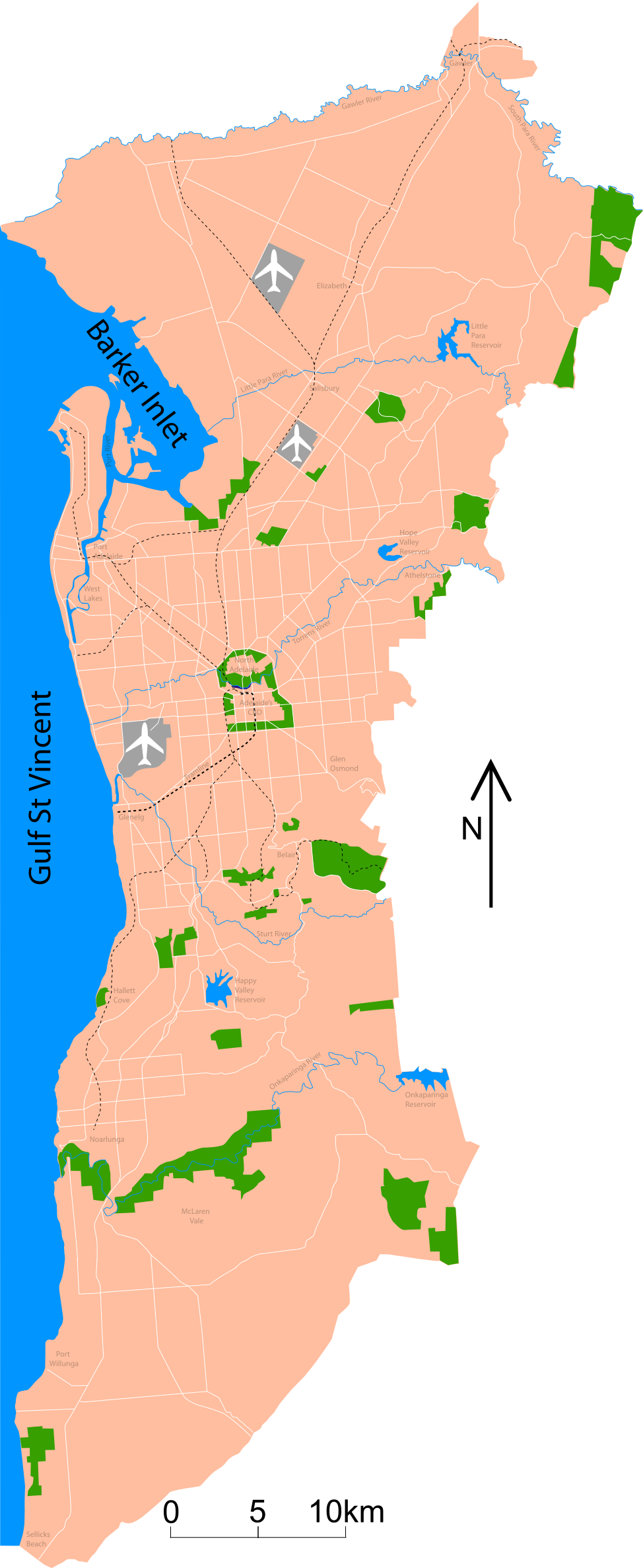
Map of Adelaide Shows major roads (per gregory's 2004 street directory), airports (adelaide, parafield and edinburgh airforce base) and all public reserves or parks > about 130 acres. Council district maps dated from 2004->2007 used to determine the landward boundary |
| Date | |
| Source | Own work |
| Author | Peripitus |
| SVG development | This map was created with Adobe Illustrator. |
Licensing
I, the copyright holder of this work, hereby publish it under the following licenses:

|
Permission is granted to copy, distribute and/or modify this document under the terms of the GNU Free Documentation License, Version 1.2 or any later version published by the Free Software Foundation; with no Invariant Sections, no Front-Cover Texts, and no Back-Cover Texts. A copy of the license is included in the section entitled GNU Free Documentation License. |
This file is licensed under the Creative Commons Attribution-Share Alike 3.0 Unported, 2.5 Generic, 2.0 Generic and 1.0 Generic license.
- You are free:
- to share – to copy, distribute and transmit the work
- to remix – to adapt the work
- Under the following conditions:
- attribution – You must give appropriate credit, provide a link to the license, and indicate if changes were made. You may do so in any reasonable manner, but not in any way that suggests the licensor endorses you or your use.
- share alike – If you remix, transform, or build upon the material, you must distribute your contributions under the same or compatible license as the original.
You may select the license of your choice.
File history
Click on a date/time to view the file as it appeared at that time.
| Date/Time | Thumbnail | Dimensions | User | Comment | |
|---|---|---|---|---|---|
| current | 10:53, 26 January 2015 | 974 × 2,373 (298 KB) | Wereldburger758 | Valid SVG now. | |
| 02:45, 3 November 2007 | 974 × 2,373 (331 KB) | Peripitus | {{Information |Description=Map of Adelaide Shows major roads (per gregory's 2004 street directory), airports (adelaide, parafield and edinburgh airforce base) and all public reserves or parks > about 130 acres. Council district maps dated from 2004->2007 | ||
| 09:13, 24 October 2007 | 974 × 2,373 (136 KB) | Peripitus | {{Information |Description=Map of Adelaide Shows major roads (per gregory's 2004 street directory), airports (adelaide, parafield and edinburgh airforce base) and all public reserves or parks > about 130 acres. Council district maps dated from 2004->2007 | ||
| 21:32, 23 October 2007 | 487 × 1,188 (144 KB) | Peripitus | {{Information |Description=Map of Adelaide Shows major roads (per gregory's 2004 street directory), airports (adelaide, parafield and edinburgh airforce base) and all public reserves or parks > about 130 acres. Council district maps dated from 2004->2007 | ||
| 13:38, 23 October 2007 | 487 × 1,188 (145 KB) | Peripitus | {{Information |Description=Map of Adelaide Shows major roads (per gregory's 2004 street directory), airports (adelaide, parafield and edinburgh airforce base) and all public reserves or parks > about 130 acres. Council district maps dated from 2004->2007 | ||
| 13:35, 23 October 2007 |  | 749 × 1,188 (145 KB) | Peripitus | Reverted to version as of 13:26, 23 October 2007 | |
| 13:34, 23 October 2007 | 487 × 1,188 (166 KB) | Peripitus | {{Information |Description=Map of Adelaide Shows major roads (per gregory's 2004 street directory), airports (adelaide, parafield and edinburgh airforce base) and all public reserves or parks > about 130 acres. Council district maps dated from 2004->2007 | ||
| 13:26, 23 October 2007 |  | 749 × 1,188 (145 KB) | Peripitus | {{Information |Description=Map of Adelaide Shows major roads (per gregory's 2004 street directory), airports (adelaide, parafield and edinburgh airforce base) and all public reserves or parks > about 130 acres. Council district maps dated from 2004->2007 |
File usage
The following 3 pages use this file:
Global file usage
The following other wikis use this file:
- Usage on af.wikipedia.org
- Usage on ckb.wikipedia.org
- Usage on el.wikipedia.org
- Usage on es.wikipedia.org
- Usage on hr.wikipedia.org
- Usage on ka.wikipedia.org
- Usage on ms.wikipedia.org
- Usage on ru.wikipedia.org